BOTTOM LINE
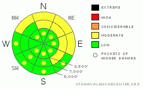
Danger by aspect and elevation on slopes approaching 35° or steeper.
(click HERE for tomorrow's danger rating)
|
Danger Rose Tutorial
|
The avalanche danger for the Manti Skyline is LOW. Daytime heating will bring pockets of MODERATE hazard into play in the afternoon. Be on the lookout for an isolated wind slab or two on wind loaded high elevation N & NE facing slopes. As the heat comes on, watch for sensitive cornices & wet point release avalanches. |
|
|
CURRENT CONDITIONS |

|
Mild temperatures have settled our storm snow right out. Soft conditions exist out there, but you've got to hunt for them. Try the high elevation N - NE aspects for your pow fix. While the other aspects are not soft, they are high in traction, making for perfect exploration conditions. |
|
|
RECENT ACTIVITY |

|
Aspects that receive intense daytime heating are starting to point release in select locations.
No other recent activity reported or observed. |
|
|
THREAT #1 |

|
| WHERE |
PROBABILITY |
SIZE |
TREND |
|
|
|
|
| |
|
|
Over the next
24
hours.
|
|
|
While it's a non-issue throughout most of the forecast area, you can still find a shallow wind slab on high elevation N through E facing aspects. These are small, manageable avalanches. However, they could pose a threat, say if you're descending in the forest. |
|
|
THREAT #2 |

|
| WHERE |
PROBABILITY |
SIZE |
TREND |

|
|
|
|
| |
|
|
Over the next
24
hours.
|
|
|
It's looking like it will be a warm weekend in Central Utah. Daytime temps will be a few degrees above freezing even at our highest elevations. Watch for wet point release avalanches. These will be slow moving and will involve only our last storm or two. Give these things some respect though; they do pack a wallop when they finally catch up with you. You don't want your machine to be hit by one of these at the bottom of a run-out. |
|
|
THREAT #3 |

|
| WHERE |
PROBABILITY |
SIZE |
TREND |

|
|
|
|
| |
|
|
Over the next
24
hours.
|
|
|
As daytime heating occurs, cornices will become a bit more sensitive. Avoid high marking under these beasts particularly if temps jump above the freezing mark. These things weigh many tons, and getting hit by one will surely ruin your day. You don't want to be under one of these when they collapse! |
|
|
MOUNTAIN WEATHER |

|
Winds are light out of the S-SW this morning while temps are in the mid teens. Temps will climb just above freezing today even at the highest elevations. Unfortunately, this will likely end the powder holiday we've been enjoying, at least until early next week. A series of disturbances move though the area beginning Monday, continuing through the weekend. These storms should freshen up our snow surface. |
|
|
GENERAL ANNOUNCEMENTS |
If you see or trigger an avalanche it would do the community good to report it. Your observations help to save the lives of others. The forecast area is large, and due to funding cuts I only have one field day to spend on the Skyline. This means that I can't possibly see it all. I need you to help me, help you. Please share your observations and experiences:
Shoot me an email: grant@utahavalanchecenter.org and or call me on my cell: 406-370-1337. Thanks!
Due to budget cuts we are only able to produce an advisory that is updated each Saturday morning.
Keep in mind that conditions change dramatically and that information may not be relevant for later in the week.
Want to schedule an avalanche awareness talk? Contact me for details.
This forecast will be updated by 7:00am Saturday February 28th. |
|
|
This information does not apply to developed ski areas or highways where avalanche control is normally done. This advisory is from the U.S.D.A. Forest Service, which is solely responsible for its content. This advisory describes general avalanche conditions and local variations always occur. |
|
This advisory provided by the USDA Forest Service, in partnership with:
The Friends of the Utah Avalanche Center, Utah Division of State Parks and Recreation, Utah Division of Emergency Management, Salt Lake County, Salt Lake Unified Fire Authority and the friends of the La Sal Avalanche Center. See our Sponsors Page for a complete list. |
