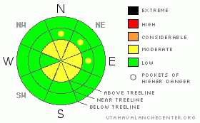
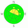
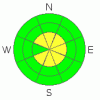
BOTTOM LINE
Danger by aspect and elevation on slopes approaching 35° or steeper.
(click HERE for tomorrow's danger rating)
|
Danger Rose Tutorial
|
While we've turned the corner on our deep slab instabilities, we have a variety of slabs from 1 to 2' in depth lurking out there. We're also building fresh wind slabs in the forecast area as I write. Thus, the avalanche hazard is MODERATE on all slopes above tree line (with the exception of due West). There are also pockets of MODERATE danger in the trees on N, NE & E aspects. All other slopes have a LOW hazard rating. |
|
|
CURRENT CONDITIONS |

|
This past week has brought temperatures above freezing all the way to ridge-top. While it hasn't improved riding conditions out there, it has helped to bond and consolidate our snowpack. Shady aspects still hold some fresh settled powder if you can find any without tracks on it. Those aspects that face into the sun a bit more have a thick melt freeze crust on top of them. A series of unsettled lows are currently moving across the area. We'll see 6 - 12" by Sunday night. |
|
|
RECENT ACTIVITY |

|
Friday’s field day was low visibility at best, but it did burn off a bit in the afternoon allowing me to get a good look around. I did not see any new activity in the area, nor have I heard of any riders triggering anything in our neck of the woods. Folks have certainly been getting after it though! |
|
|
THREAT #1 |

|
| WHERE |
PROBABILITY |
SIZE |
TREND |
|
|
|
|
| |
|
|
Over the next
24
hours.
|
|
|
Steve was out earlier this week and noted about a foot of settled snow sitting on top of a buried surface hoar layer at upper elevations facing N-NE in Seeley Canyon. I too found some interesting weakness's on Friday. Notably, the upper 21" of the snowpack failing hard and fast on an E - NE facing slope near electric lake. It took a hard trigger to initiate the slab, but once it failed, it came out like a cash register door. This means that it's got a fair bit of energy in it and could be a player especially near rock outcroppings. While it is an isolated problem, it is possible to trigger an avalanche out there.
As always, pit profiles are available here for the snow geeks among us. |
|
|
THREAT #2 |

|
| WHERE |
PROBABILITY |
SIZE |
TREND |
|
|
|
|
| |
|
|
Over the next
24
hours.
|
|
|
As our storm total builds you can bet that the wind will push the new snow around as it's known to do on the plateau. With a potential for 6-12" of new, we could see some deep sensitive wind slabs forming on the lee aspects. Keep an eye out for fresh wind slabs on each slope you approach and keep those machines pointed away from run out zones while you're watching your buddies. |
|
|
MOUNTAIN WEATHER |

|
Currently it's in the low 20's throughout the forecast area. Winds are out of the S - SE in the single digits. Another front will move through the area this morning, continuing to blow and obscure visibility. There's a very intense storm raging on just to the South of us. While we're missing the bulk of it, we are getting a nice refresher to our snow surface that will continue through Monday. Beyond that the models are a bit shaky, but there is a chance for snow all week. |
|
|
GENERAL ANNOUNCEMENTS |
Big thanks this week to Glen Zumwalt & the boys at Big Pine Motor Sports in Fairview for their ongoing support of the UAC. They provide the sled that allows me to develop this forecast. Thanks!
Also a huge thank you to Steve Cote for his awesome observations and incredible volunteer contributions.
If you see or trigger an avalanche it would do the community good to report it. Your observations help to save the lives of others. The forecast area is large, and due to funding cuts I only have one field day to spend on the Skyline. This means that I can't possibly see it all. I need you to help me, help you. Please share your observations and experiences:
Shoot me an email: grant@utahavalanchecenter.org and or call me on my cell: 406-370-1337. Thanks!
Our third annual Avalanche Center fundraising ride is Saturday February 7th. Click here for more details.
Due to budget cuts we are only able to produce an advisory that is updated each Saturday morning.
Keep in mind that conditions change dramatically and that information may not be relevant for later in the week.
Want to schedule an avalanche awareness talk? Contact me for details. |
|
|
This information does not apply to developed ski areas or highways where avalanche control is normally done. This advisory is from the U.S.D.A. Forest Service, which is solely responsible for its content. This advisory describes general avalanche conditions and local variations always occur. |
|
This advisory provided by the USDA Forest Service, in partnership with:
The Friends of the Utah Avalanche Center, Utah Division of State Parks and Recreation, Utah Division of Emergency Management, Salt Lake County, Salt Lake Unified Fire Authority and the friends of the La Sal Avalanche Center. See our Sponsors Page for a complete list. |
