BOTTOM LINE
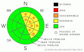
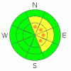
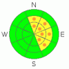
Danger by aspect and elevation on slopes approaching 35° or steeper.
(click HERE for tomorrow's danger rating)
|
Danger Rose Tutorial
|
A MODERATE avalanche danger for the Manti Skyline today and through the weekend on slopes 35 degrees or steeper, above 9,000' that face north, northeast, east and southeast, meaning human triggered avalanche are possible.. Pockets of CONSIDERABLE avalanche danger exist on these same slopes where recent storm snow has formed into new wind slabs, meaning human triggered avalanches are probable. There is a LOW avalanche danger on all other slopes. Some of the models are showing a big warm up next week, if this occurs avalanche danger may rise. |
|
|
CURRENT CONDITIONS |

|
Overnight winds were steady out of the West, averaging 20 mph. As the front passed, trailhead temperatures dropped to the single digits where they currently sit. While each passing storm improves the riding conditions out there, it's still early season, and our snowpack is pretty thin, in many places stumps ard rocks aren't even covered yet. Above 9,000' depths are averaging about a foot of settled snow, however, the wind has blown in lee aspects as deep as 4'. |
|
|
RECENT ACTIVITY |

|
Below 9000', the pack is just to thin to recreate on. Above 9000' the story is a little different. Windward slopes are scroured & thin. Lee slopes above 9000' are fat and windloaded. My field day revealed signs of a recent natural avalanche cycle on upper elevation E facing aspects. A Size 1.5 hard slab avalanche pulled out naturally on the Big Drift near the top of Fairview Canyon. 150' wide x 400' long x 4' deep. This destructive avalanche failed on weak basal facets that exist near the ground. |
|
|
THREAT #1 |

|
| WHERE |
PROBABILITY |
SIZE |
TREND |
|
|
|
|
| |
|
|
Over the next
24
hours.
|
|
|
Deep hard slabs have formed on lee aspects above 9000'. With our prevalent westerly flow, this means that slopes facing the east side of the compass are suspect. While the recent natural cycle relieved stress on a few slopes, there are still many slopes out there that are capable of producing large human triggered hard slab avalanches. Pit profile here. Be aware of signs of instability such as shooting cracks or audible "Whoomphing." Remember, it's a long winter and this is just the beginning. Triggering one of these hard slabs can quickly destroy your season. Use numerous small test slopes that have little or no consequence to get a feel for the snowpack before venturing into the bigger terrain. |
|
|
THREAT #2 |

|
| WHERE |
PROBABILITY |
SIZE |
TREND |
|
|
|
|
| |
|
|
Over the next
24
hours.
|
|
|
Remember, wind is the architect of avalanches. With our steady westerly winds, any new storm snow will be formed into sensitvie wind slabs on lee (East) aspects. Be aware that these smaller slabs could step down and trigger the lurking hard slabs once they are moving. |
|
|
MOUNTAIN WEATHER |

|
It looks like we're in the snowbelt now. We should pick up a couple inches everyday through the end of next week. Temperatures will rise to a moderate level and our winds will remain steady out of the west. Some of the models are predicting a big warm up which would spike avalanche danger in the short term, but would help us to settle things out in the long term. |
|
|
This information does not apply to developed ski areas or highways where avalanche control is normally done. This advisory is from the U.S.D.A. Forest Service, which is solely responsible for its content. This advisory describes general avalanche conditions and local variations always occur. |
|
This advisory provided by the USDA Forest Service, in partnership with:
The Friends of the Utah Avalanche Center, Utah Division of State Parks and Recreation, Utah Division of Emergency Management, Salt Lake County, Salt Lake Unified Fire Authority and the friends of the La Sal Avalanche Center. See our Sponsors Page for a complete list. |
