SPECIAL ANNOUNCEMENT |
 |
Very sadly, there was an avalanche fatality yesterday, and we offer our condolences to the family and friends of Jamie Pierre.
Alta and Snowbird resorts are closed to all touring and uphill traffic as they prepare to open for the season. |
|
|
BOTTOM LINE
Danger by aspect and elevation on slopes approaching 35° or steeper.
(click HERE for tomorrow's danger rating)
|
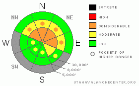
Danger Rose Tutorial
|
The avalanche danger continues to be CONSIDERABLE (Level 3) today on northwest through easterly facing slopes above about 9500’, where a triggered avalanche will be 1 to 2 feet deep and up to 250’ wide, failing on the weak facets near the ground. CONSIDERABLE means dangerous avalanche conditions exist and human triggered avalanches are likely. Avalanches can be triggered from a distance today. There is also a MODERATE (level 2) danger of triggering a wind drift, most widespread along the higher ridgelines. |
|
|
CURRENT CONDITIONS |

|
Under clear skies, temperatures are in the teens to low 20s this morning, and the westerly winds are mostly in the 15 to 20 mph range, with gusts into the 30s. However, a few of the highest peaks, such as Mt Ogden, have significantly stiffer speeds, with sustained averages into the mid 40s and gusts into the 50s. The snowpack is still very shallow, with total depths averaging 10 to 30 inches, and dodging rocks and stumps is a full time endeavor. |
|
|
RECENT ACTIVITY |

|
In addition to yesterday’s unhappy fatality, there were approximately 10 other human triggered avalanches yesterday, with the epicenter of activity in upper Little Cottonwood Canyon, mostly in the unopened, uncontrolled terrain of the Alta and Snowbird ski areas. Most of these incidents were unintentional, with several people caught and carried, and one person breaking their femur. All the slides failed on the facets near the ground, on northwesterly through easterly facing slopes, mostly above 9,500’. The Current Conditions page has multiple listings on many of these incidents, but each observation has good information – thank you to everyone who submitted. There is also a preliminary accident report on the fatality, which will be updated later today. Widespread cracking and collapsing was reported yesterday, including in the Ogden area mountains. |
|
|
THREAT #1 |

|
| WHERE |
PROBABILITY |
SIZE |
TREND |
|
|
|
|
| |
|
|
Over the next
24 hours.
|
|
|
The snowpack is talking to us – the widespread collapsing and whoomphing noises are the sound of the weak faceted snow near the ground failing as we travel across it.
I know I find it hard to refocus on avalanches so early in the season, when there is so little snow on the ground I’m finding it hard to even find a place to make turns without hitting rock and logs. But the numb sensation I have this morning after an avalanche fatality tells me it’s time to go slow and reevaluate what’s going on in the snowpack. As we head out early this season, we are looking for terrain where there is a “base” of old snow, so we won’t hit rocks. But basically, anywhere there is a “base” of old snow this winter – upper elevation, shady slopes - it’s Bad News. All that old snow is “rotted” – what we call faceted – into a mix of sugary snow and weak crusts, and this is what all the avalanches are failing on. While this weak snow is most common on the shady northwest through northeasterly facing slopes above about 9,500’, pockets of faceted snow do exist on very shady slopes down to about.9,000’.
Today, it is still likely that a person could trigger an avalanche on one of these steep, northerly facing upper elevation slopes. Avoid steep slopes in this terrain, and stick to low angle slopes. |
|
|
THREAT #2 |

|
| WHERE |
PROBABILITY |
SIZE |
TREND |

|
|
|
|
| |
|
|
Over the next
24 hours.
|
|
|
A second issue today is the sensitive wind drifts that have been formed by the strong winds over the past few days. Swirling through the terrain, the winds have drifted snow on a variety of aspects, mostly along the higher ridges, but also down into the mid elevation terrain. These drifts will be more stubborn today, but can be triggered on steep slopes and with slides then possibly stepping down into the faceted snow. |
|
|
MOUNTAIN WEATHER |

|
A cool, moist northwest flow will be over the area through the week. For today, partly cloudy skies, with temperatures warming into the low 30’s at 8,000’ and near 20 at 10,000’. Westerly winds will be in the 15 to 25 mph range, with gusts to 35 at most stations. Add 10 mph to the averages and gusts for wind speeds along the highest ridgelines and peaks. Increasing clouds tonight as a weak disturbance brings a chance for light snow into Tuesday. The next significant storm will arrive Friday into Saturday, with a strong cold front dropping temperatures into the single digits. |
|
|
GENERAL ANNOUNCEMENTS |
If you trigger an avalanche in the backcountry - especially if you are adjacent to a ski area – please call the following teams to alert them to the slide and whether anyone is missing or not. Rescue teams can be exposed to significant hazard when responding to avalanches, and do not want to do so when unneeded. Thanks.
Salt Lake – Alta Central (801-742-2033)
Ogden – Snowbasin Patrol Dispatch (801-620-1017)
Provo – Sundance Patrol Dispatch (801-223-4150)
We appreciate all your avalanche and snow observations. You can submit information on our web site, (avalanche and snow observations), by calling 801-524-5304 or 800-662-4140, or email us at uac@utahavalanchecenter.org.
The information in this advisory is from the U.S. Forest Service, which is solely responsible for its content. This advisory describes general avalanche conditions and local variations always occur.
We will update this forecast tomorrow morning. Thanks for calling. |
|
|
This information does not apply to developed ski areas or highways where avalanche control is normally done. This advisory is from the U.S.D.A. Forest Service, which is solely responsible for its content. This advisory describes general avalanche conditions and local variations always occur. |
|
This advisory provided by the USDA Forest Service, in partnership with:
The Friends of the Utah Avalanche Center, Utah Division of State Parks and Recreation, Utah Division of Emergency Management, Salt Lake County, Salt Lake Unified Fire Authority and the friends of the La Sal Avalanche Center. See our Sponsors Page for a complete list. |
