25th Annual Black Diamond Fall Fundraising Party
Thursday, September 13; 6:00-10:00 PM; Black Diamond Parking Lot
25th Annual Black Diamond Fall Fundraising Party
Thursday, September 13; 6:00-10:00 PM; Black Diamond Parking Lot
| Advisory: Salt Lake Area Mountains | Issued by Evelyn Lees for Saturday - March 31, 2018 - 6:17am |
|---|


|
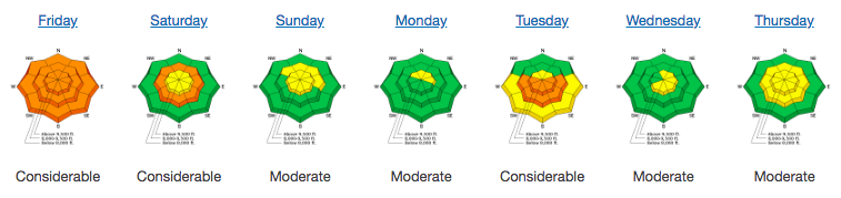
bottom line The avalanche danger is generally LOW this morning, but may rise to MODERATE with daytime heating. Wet loose sluffs could become easy to trigger if you are on steep slopes when the skies clear and there is strong sun. In isolated areas, shallow wind drifts can be triggered, most likely on upper elevation, northerly through easterly facing slopes. There also remains a very slight chance of triggering a deep slab avalanche, again most likely in upper elevation northerly through easterly facing terrain that is rocky or has a shallower snow pack, especially slopes that avalanched one or more times this winter.
|
 |
special announcement The newest issue of the Powder Cloud, the newsletter of the Utah Avalanche Center, is hot off the digital presses. You can look at new and old issues of the Powder Cloud, other essays, and blogs in the menu above or click here.
The last day to support the UAC when you shop at Whole Foods. The Whole Foods Bag Donation ends Saturday March 31. When you bring your own bags to Whole Foods in Sugar House, Trolley Square, and Cottonwood Heights you can choose to have the UAC be the recipient of your 10 cent bag credit. The UAC Marketplace is still open. Our online marketplace still has deals on skis, packs, airbag packs, beacons, snowshoes, soft goods and much more. |
 |
current conditions Skies are partly cloudy this morning, and temperatures have a large head start on yesterday – many stations are 7 to 10 degrees warmer than 24 hours ago – in the 20s at the upper elevations and 30s at the mid elevations. The lower elevations of the Park City, Ogden and Provo area mountains even have a few readings near 40°F. The west to southwesterly winds are breezy, averaging 10 to 15 mph at the mid elevations, with the high peaks averaging to 25 mph. There should be a good window for corn today when the smooth, sunny slopes first soften and there is some soft, recrystallized powder on upper northerly facing slopes in wind-sheltered terrain. But there are widespread icy crusts, some which may not soften, so be prepared for hard, “slide for life” conditions on many aspects in steep terrain. Ice axes, crampons and ski crampons may be appropriate for steep objectives. The modestly-deep snowpack provides excellent travel conditions for touring in the alpine zones. Our Week in Review summarizes weather and avalanche activity over the past week:
|
 |
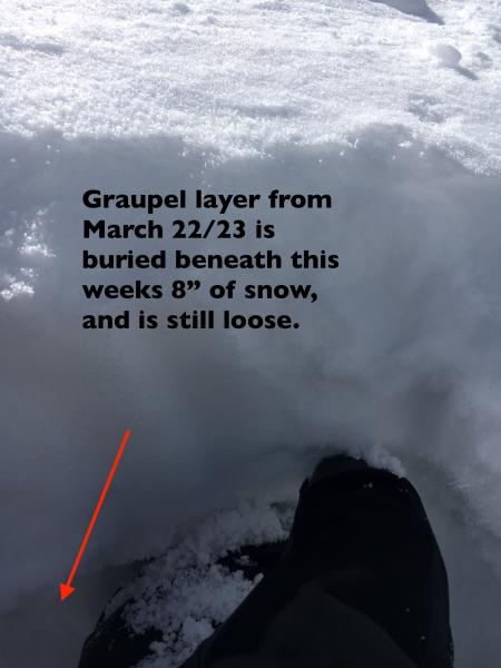
recent activity What caught my attention was yesterday’s couple of explosive released wind slabs in the Cottonwoods that failed on last Friday’s buried graupel. These slides were on northerly facing slopes, above 10,500’, 4 to 16” deep, and had debris deep enough to bury a person. No other avalanches were reported.
|
| type | aspect/elevation | characteristics |
|---|

|

|
LIKELIHOOD
 LIKELY
UNLIKELY
SIZE
 LARGE
SMALL
TREND
 INCREASING DANGER
SAME
DECREASING DANGER
|
|
description
With a warmer start to the day, the snow’s overnight night refreeze could be short lived today. It’s going to be a balance between wind, clouds and sun. Wind and clouds keep the snow cool. But if the sun comes out in full force where you are, the snow surface will rapidly heat and wet loose sluffs will become easy to trigger. Once the snow becomes wet and loose, it’s time to get off of and out from under steep slopes, and move to a cooler aspect or lower angle terrain. I've spent time this morning looking at this loop - a model and forecasting tool - of what they think the cloud cover will look like. You need to subtract 6 hours from the time to get our current Mountain Daylight time. Perhaps thicker clouds in the Ogden and Logan area mountains, with more breaks to the south? |
| type | aspect/elevation | characteristics |
|---|

|

|
LIKELIHOOD
 LIKELY
UNLIKELY
SIZE
 LARGE
SMALL
TREND
 INCREASING DANGER
SAME
DECREASING DANGER
|
|
description
The avalanche hazard is generally Low and avalanches are unlikely. But travel in avalanche terrain is never a completely safe game, so watch for the following issues on isolated features: Wind slabs: As yesterday’s Cottonwood avalanches indicate, there are places where wind drifts could be triggered, perhaps by a person – northerly and easterly facing slopes in the highest alpine terrain are the most suspect. These drifts would be failing on a graupel layer - so look for this layering by digging down a foot or so, and search for a layer of loose graupel beneath the surface snow or wind drifts. Persistent Deep Slab - If you’re wondering what happened to the Deep Slab avalanche problem, catch up with Mark’s great video summary of the current state of the snowpack below. The issue and the weak layers are not gone, rather they are currently dormant and avalanching on these deeper weak layers is unlikely. |
 |
weather A mild, westerly flow will be over northern Utah for the weekend. A weak weather disturbance will bring increasing clouds later today and tonight, but no snow. Temperatures will warm to around 50°F at 8,000’ today and close to 40°F at 10,000’. The west to southwesterly wind are forecast to average in the 10 to 20 mph range at the mid elevations, and 25 to 35 mph at the highest elevation, with gusts occasionally reaching 50 mph. Mostly sunny skies on Sunday, with temperatures almost as warm. Next week is looking unsettled, with possible snow. |
| general announcements CLICK HERE FOR MORE GENERAL INFO AND FAQ The UAC has new support programs with Outdoor Research and Darn Tough. Support the UAC through your daily shopping. When you shop at Smith's, or online at Outdoor Research, REI, Backcountry.com, Darn Tough, Patagonia, NRS, Amazon, eBay a portion of your purchase will be donated to the FUAC. See our Donate Page for more details on how you can support the UAC when you shop. Benefit the Utah Avalanche Center when you buy or sell on eBay - set the Utah Avalanche Center as a favorite non-profit in your eBay account here and click on eBay gives when you buy or sell. You can choose to have your seller fees donated to the UAC, which doesn't cost you a penny This information does not apply to developed ski areas or highways where avalanche control is normally done. This advisory is from the U.S.D.A. Forest Service, which is solely responsible for its content. This advisory describes general avalanche conditions and local variations always occur. |