25th Annual Black Diamond Fall Fundraising Party
Thursday, September 13; 6:00-10:00 PM; Black Diamond Parking Lot
25th Annual Black Diamond Fall Fundraising Party
Thursday, September 13; 6:00-10:00 PM; Black Diamond Parking Lot
| Advisory: Salt Lake Area Mountains | Issued by Eric Trenbeath for Sunday - March 4, 2018 - 5:39am |
|---|


|
bottom line Dangerous avalanche conditions exist and the danger is HIGH in upper elevation terrain that has received more than a foot of snow and that has recent deposits of wind drifted snow. Avalanche terrain should be avoided in these areas and that includes staying out from under steep slopes and run out zones. At mid and lower elevations the avalanche danger is CONSIDERABLE. Backcountry travelers need to posess excellent snowpack evaluation and route finding skills today.
|
 |
special avalanche bulletin The avalanche danger will be on the rise today with both human triggered and natural avalanche activity likely. Snowpack conditions are complex and varied and backcountry travel in avalanche terrain is not recommended. |
 |
special announcement This is Eric Trenbeath up from Moab on an exchange with Drew Hardesty. I'll be posting advisories today and tomorrow. It's good to be back in my old stomping grounds! The latest edition of the UAC podcast is live - "A Conversation with Tom Kimbrough. Hemingway of the Wasatch". Tom is a retired climbing ranger in Grand Teton National Park, and a longtime avalanche forecaster with the UAC. A role model and mentor to many of us. Sit back and enjoy listening to Drew having a conversation with Tom! Spend some time improving your rescue skills or learning about avalanches in this upcoming Salt Lake City area class:
|
 |
current conditions The storm has finally arrived and snow began falling shortly after midnight. As of 6:00 am this morning the upper Cottonwoods had received 8-12" of new snow with around 6" on the Park City side of the range. Southwesterly winds that blew strong for the past couple of days began to slowly taper off about the time the snow started to fall. They averaged 20-30 mph with gusts as high as 50 overnight, and have begun a shift westerly averaging 15-20 mph. |
 |
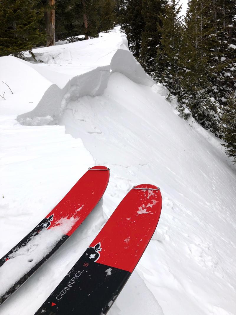
recent activity A few more human triggered avalanches were reported from the backcountry yesterday including relatively shallow wind slabs at the upper end of the Cottonwood Canyons, to deeper, persistent slab avalanches on the Central Wasatch periphery in Porter Fork. Expect the additional snow load today to put further stress on buried weak layers.
Photo 1,2: Andy Dorais, Photo 3: Jake Krong |
| type | aspect/elevation | characteristics |
|---|

|

|
LIKELIHOOD
 LIKELY
UNLIKELY
SIZE
 LARGE
SMALL
TREND
 INCREASING DANGER
SAME
DECREASING DANGER
|
|
description
Both natural and human triggered avalanches in the new snow are likely today, particularly at upper elevations, and specifically in the upper Cottonwoods where up to 18" of snow is expected. Loose snow sluffs and cohesive soft slab releases are likely on all aspects with the greatest danger on steep slopes facing N-NE-E. Backcountry travelers should avoid steep steep slopes and stay out from under run out zones. |
| type | aspect/elevation | characteristics |
|---|

|

|
LIKELIHOOD
 LIKELY
UNLIKELY
SIZE
LARGE
SMALL
TREND
INCREASING DANGER
SAME
DECREASING DANGER
|
|
description
Avalanches breaking into old snow have been reported this past week. These include slides releasing on layers of faceted snow at the mid-pack, as well as down near the ground. Terrain where you are most likely to encounter this problem can be found above 9000' on aspects facing W-N-SE. Slopes that are most suspect include thinner snowpack areas outside of the upper Cottonwoods, as well as slopes that have already slid this season. The additional load will be the first significant test on these weak layers and many slopes will be ripe for a human trigger. A triggered persistent slab 3' deep or more would be very dangerous and backcountry travelers should avoid steep slopes where this probem is suspect. |
| type | aspect/elevation | characteristics |
|---|

|

|
LIKELIHOOD
LIKELY
UNLIKELY
SIZE
LARGE
SMALL
TREND
INCREASING DANGER
SAME
DECREASING DANGER
|
|
description
Northwest winds will be on the increase drifting snow on the lee sides of ridge crests and terrain features in upper elevation wind exposed terrain where fresh drifts more than 2' deep will be found. Backcountry travelers should avoid any steep slope with recent deposits of wind drifted snow. A triggered wind slab also has the potential to step down creating a deeper and more dangerous avalanche. |
 |
weather The storm has arrived and snow should continue through the day, tapering off around noon. Up to 18" is possible in the upper Cottonwoods and a foot over the Central Wasatch periphery. NW winds will increase to 20-30 mph and mountain temps will be in the low teens. |
| general announcements CLICK HERE FOR MORE GENERAL INFO AND FAQ The UAC has new support programs with Outdoor Research and Darn Tough. Support the UAC through your daily shopping. When you shop at Smith's, or online at Outdoor Research, REI, Backcountry.com, Darn Tough, Patagonia, NRS, Amazon, eBay a portion of your purchase will be donated to the FUAC. See our Donate Page for more details on how you can support the UAC when you shop. Benefit the Utah Avalanche Center when you buy or sell on eBay - set the Utah Avalanche Center as a favorite non-profit in your eBay account here and click on eBay gives when you buy or sell. You can choose to have your seller fees donated to the UAC, which doesn't cost you a penny This information does not apply to developed ski areas or highways where avalanche control is normally done. This advisory is from the U.S.D.A. Forest Service, which is solely responsible for its content. This advisory describes general avalanche conditions and local variations always occur. |