25th Annual Black Diamond Fall Fundraising Party
Thursday, September 13; 6:00-10:00 PM; Black Diamond Parking Lot
25th Annual Black Diamond Fall Fundraising Party
Thursday, September 13; 6:00-10:00 PM; Black Diamond Parking Lot
| Advisory: Salt Lake Area Mountains | Issued by Evelyn Lees for Monday - January 15, 2018 - 6:47am |
|---|

|
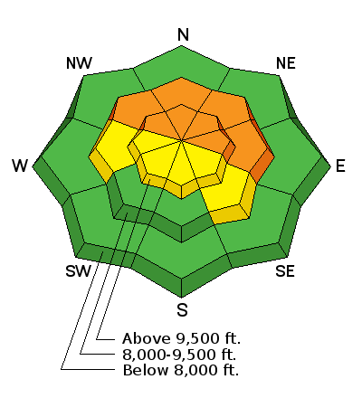
bottom line The Avalanche Danger remains CONSIDERABLE on steep, mid and upper elevation slopes facing northerly through easterly. Avalanches 2 to 3 feet deep can still be triggered by a person, on slope, from a distance or from below. Avoid travel on and below these slopes. Wet loose sluffs are possible today on all steep, sunny slopes and perhaps on shady mid and lower elevation slopes during periods of high, thin clouds. If you're headed into the backcountry - or exiting though the gates at the ski area - you must have the proper gear, training, and skilled partners.
|
 |
special announcement Spend some time improving your rescue skills or learning about avalanches in these two, upcoming Salt Lake City area classes:
Come watch what some describe as "Top Gun on the Ski Slopes" - Aspen Extreme. Get our your best 1-piece and join the UAC at Brewvies for a fundraiser on 17 January. To get help in an emergency (to request a rescue) in the Wasatch, call 911. Be prepared to give your GPS coordinates or the run name. Dispatchers have a copy of the Wasatch Backcountry Ski map. If you trigger an avalanche in the backcountry, but no one is hurt and you do not need assistance, please notify the nearest ski area dispatch to avoid a needless response by rescue teams. Thanks.
|
 |
current conditions It’s beautiful calm, clear morning in the mountains – temperatures are in the twenties, with a few teens in the drainage bottoms. The northerly winds are very light, less than 10 mph, with the highest peaks only averaging 15 mph. If you are searching for powder, head to wind sheltered, low angle shady slopes. All the sunny slopes will be crusted this morning, damp and sloppy later in the day. Spoiler alert: warm temperatures combined with possible high, thin clouds may cause “greenhousing”, heating the snow on the northerly facing slopes today. |
 |
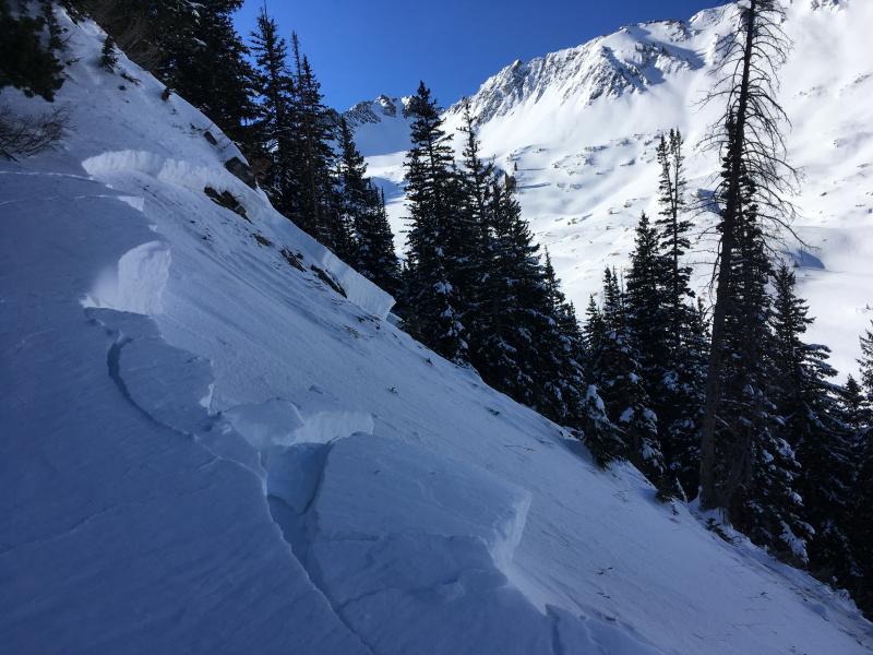
recent activity Backcountry: One notable slide from yesterday – on NW facing Powerline ridge at 9,400’ – no exact details on how it was triggered, but a scary looking slide running down into trees. There were continued reports of collapsing, many reports coming from the mid elevations. Resorts: With larger triggers (explosives) the Salt Lake and Park City resorts released about a dozen large avalanches yesterday, 2 to 4 feet deep, on northwest through northeasterly facing slopes. Most activity was above 10,000’, but one slide on the Park City ridgeline was at 9,000’, releasing well off the ridgeline and to the ground. Powerline Ridge slide. Cody Huges photo Full observation HERE
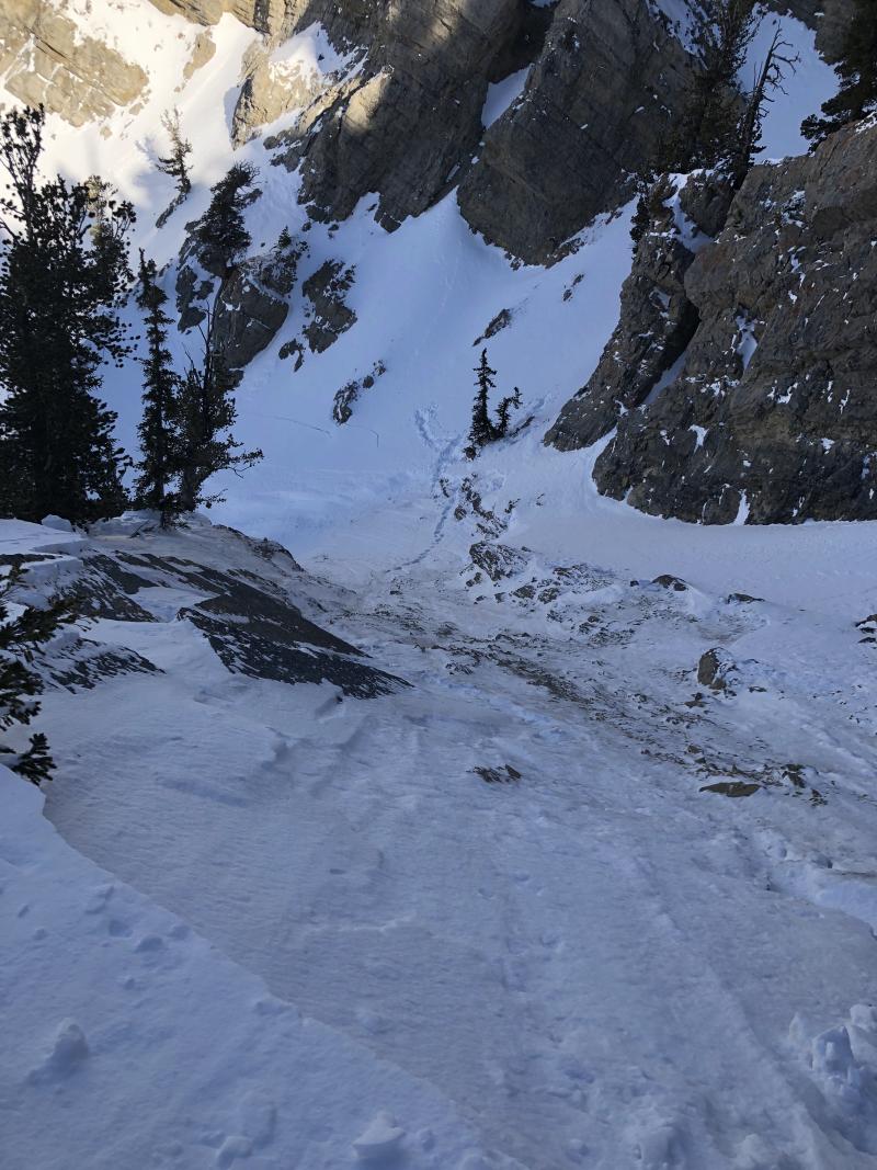
Hallway avalanche from Jan 13th?. Dave Steiner photo.
|
| type | aspect/elevation | characteristics |
|---|

|
|
LIKELIHOOD
 LIKELY
UNLIKELY
SIZE
 LARGE
SMALL
TREND
 INCREASING DANGER
SAME
DECREASING DANGER
|
|
description
“Poor structure” and a “persistent weak layer” are the buzzwords of the Wasatch snowpack. Translated – “strong snow sitting on weak snow” and “facets”. Collapsing and avalanches are indications a person can still trigger an avalanche. While with each day, the chance of triggering a slide on one of the faceted weak layers decreases, the consequences remain the same. A triggered slide would likely be 2 to 3 feet deep, and 50 to 100 feet wide. Slides have been releasing on northwest through easterly facing slopes at both the mid and upper elevations, and in some places breaking well off the ridge lines, meaning you can get out on to a slope, and have the slide break above you. Observation after observation from experienced backcountry travelers echo distrust of the snowpack, and that avoidance of the steep, shady slopes the only way to guarantee not triggering an avalanche. |
 |
weather The high pressure ridge will weaken just a bit today, allowing for periods of high thin clouds. Temperatures will warm into the upper 30s to low 40s. The northeasterly winds will be in the 5 to 15 mph range, with speeds across even the highest ridgelines only in the 10 to 20 mph range. A few snow flurries are possible Tuesday night into Wednesday, with a colder, stronger storm forecast for Friday into Saturday. |
| general announcements CLICK HERE FOR MORE GENERAL INFO AND FAQ Support the UAC through your daily shopping. When you shop at Smith's, or online at REI, Backcountry.com, Patagonia, NRS, Amazon, eBay a portion of your purchase will be donated to the FUAC. See our Donate Page for more details on how you can support the UAC when you shop. Benefit the Utah Avalanche Center when you buy or sell on eBay - set the Utah Avalanche Center as a favorite non-profit in your eBay account here and click on eBay gives when you buy or sell. You can choose to have your seller fees donated to the UAC, which doesn't cost you a penny. This information does not apply to developed ski areas or highways where avalanche control is normally done. This advisory is from the U.S.D.A. Forest Service, which is solely responsible for its content. This advisory describes general avalanche conditions and local variations always occur. |