25th Annual Black Diamond Fall Fundraising Party
Thursday, September 13; 6:00-10:00 PM; Black Diamond Parking Lot
25th Annual Black Diamond Fall Fundraising Party
Thursday, September 13; 6:00-10:00 PM; Black Diamond Parking Lot
| Advisory: Salt Lake Area Mountains | Issued by Greg Gagne for Friday - March 3, 2017 - 4:56am |
|---|

|
bottom line The avalanche hazard is generally Low this morning, and will rise to Moderate on solar aspects with daytime heating. There is also a Moderate hazard of both human-triggered and natural cornice falls along upper elevation ridge lines.
|
 |
special announcement New guest blog by Tom Diegel - The Little Things (that might keep you alive) - Part I I want to thank Dr. Cianna Wyshnytzky and the students in her "Glacial Field Methods" class at Westminster College who on Thursday evening helped me draft today's advisory. |
 |
current conditions There is a temperature inversion in the mountains this morning, with low elevation trail heads in the low teens, and in the mid 20's at mid and upper elevations. Winds are out of the west/southwest and are light at low elevations. They are blowing in the low teens at mid and upper elevations, with gusts in the 20's mph at the upper elevations. Slopes facing east, south, and west will be crusted this morning, and will soften and loosen with daytime warming. Mid and upper elevation northerly aspects will hold soft, dry snow, with wind-affected snow in the upper elevations.
Week in Review (Feb 24- Mar 2) The snowfall from the 3-4' storm from the week of February 20 settled out by Saturday Feb 25 and treated backcountry skiers and riders with a weekend of deep, soft snow with generally stable conditions. Many steep lines were skied with the only concern of sluffing in the loose, dry snow. By later Sunday afternoon, wind speeds increased ahead of yet another storm that initially arrived on a southwest flow, but switched to northwest later on Monday. Heavy snowfall during the day on Monday led to a natural cycle during periods of intense precipitation. Light snow continued overnight on Monday, with a weaker system later on Tuesday that added several more inches of snow. Storm totals (and water equivalent) since Sunday evening included:
Stability rapidly increased by Tuesday was well with most observers only noting loose sluffs in very steep terrain. West and northwest winds also began to increase later Tuesday and into Wednesday morning, with wind-affected and drifted snow in the mid and upper elevations. These drifts were sensitive earlier in the day on Wednesday, but had largely settled out and were mostly unreactive by Thursday. Warm temperatures and strong sun on Thursday created loose wet avalanche activity on east, south, and west aspects. February totals from Alta Guard (courtesy of Mark Sauer) are 114" of snow with 9.0" of water. This exceeds the average of 81.4" and is the 8th snowiest February on record. Also of note, the seasonal snowfall at Alta Guard is currently 413" and is the first time it has topped 400" for a full season since 2010-11. |
 |
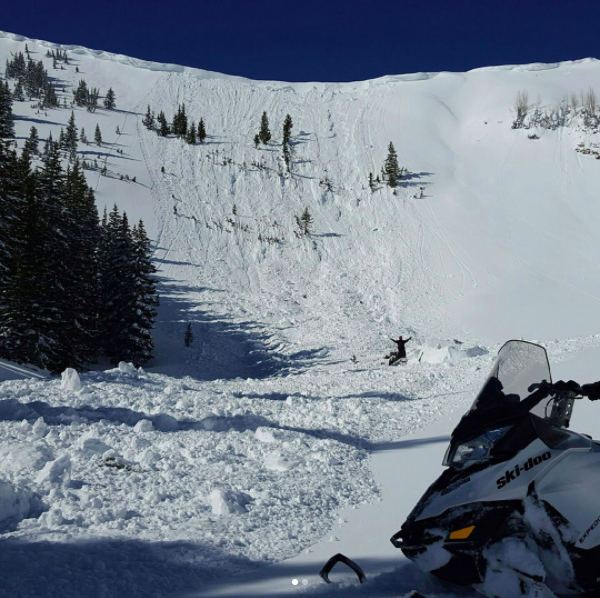
recent activity The most significant activity reported from Thursday was a natural cornice fall on Scott Hill along the Park City ridgeline (Photo @bayoudave) This occurred on an east facing slope and was 400' wide with debris 10-15' in places. This avalanche took out some large trees, and stepped to the ground in places. (We will post a summary of this avalanche on the UAC website on Friday morning.)
Otherwise, widespread loose wet activity occurred on the sunny east through west aspects, beginning with southeast by about 10 am. |
| type | aspect/elevation | characteristics |
|---|

|
|
LIKELIHOOD
 LIKELY
UNLIKELY
SIZE
 LARGE
SMALL
TREND
 INCREASING DANGER
SAME
DECREASING DANGER
|
|
description
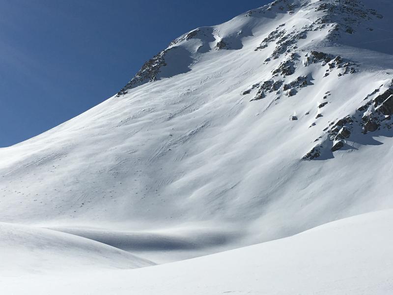
Strong sun and very warm temperatures will lead to another day of loose wet activity on solar aspects. With a clear sky and overnight temperatures below freezing, solar aspects are frozen this morning, but will quickly loosen as the sun warms the snowpack. Wet activity follows the sun, with east aspects first reactive, followed by south and then west. Wet, rollerballs are a sign the snowpack is warming, and an indication it is time to move off of and out from underneath these slopes. [Photo Mark White]
Mark also has his usual excellent write up describing the progression of wet activity on Thursday, and how he safely navigated through avalanche terrain as the snow surface warmed. |
| type | aspect/elevation | characteristics |
|---|

|

|
LIKELIHOOD
LIKELY
UNLIKELY
SIZE
 LARGE
SMALL
TREND
INCREASING DANGER
SAME
DECREASING DANGER
|
|
description
Cornices are immense this season, and the warming temperatures are only likely to increase their susceptibility to breaking and avalanching the slope below. Thursday's large slide on Scott Hill is an indication of how large and dangerous these slides can be: not only may they trigger an avalanche, but the hard, large chunks of snow from the cornice can also cause serious injury. We are generally not used to this type of avalanche activity in the Wasatch, but given the size of cornices this season, it certainly warrants our attention. If traveling along a corniced ridgeline, be sure to stay well back from the edge. It is a particularly poor idea to put in a skin track on a slope beneath large, overhanging cornices. You are likely to find these cornices on upper elevation ridges facing north through southeast. Fortunately there is plenty of safe terrain where you can avoid being underneath these monster cornices. I am describing this hazard as Moderate, but given Thursday's natural cornice fall - and the size of the slide - it could easily be listed as a Considerable hazard. Regardless, simply stay away from them. |
| type | aspect/elevation | characteristics |
|---|

|

|
LIKELIHOOD
 LIKELY
UNLIKELY
SIZE
 LARGE
SMALL
TREND
 INCREASING DANGER
SAME
DECREASING DANGER
|
|
description
Other concerns when traveling in the backcountry today: Wind Drifts - Although I was finding wind slabs in upper alpine regions to be unreactive on Thursday, Tyler Falk was able to trigger small wind drifts in the Y Couloir. Increasing winds on Friday may create a fresh batch of wind drifts at the mid and upper elevations which may be sensitive. Watch for changing conditions as the wind speeds increase, especially this aftenoon. Loose Dry Snow - Despite the very warm temperatures, mid and upper elevation north aspects still hold dry snow. Observers on Thursday were able to trigger loose dry sluffs in the top few inches of the snow surface on steep aspects. Although these sluffs are small, consider where you may end up if you get caught in one of these sluffs. Glide Avalanches - Although I am unaware of any recent glide activity, this is prime season for glide avalanches. And with our deep snowpack, these avalanches will be very large. The neighborhoods where glide avalanches occur are primarily located in Big Cottonwood Canyon and include Broads Fork, Stairs Gulch, and Mill B South. |
 |
weather Today will be another warm one with 8000' temperatures forecasted to reach the upper 40's. At 10,000' temperatures will rise to just below freezing. Clear skies to begin the day, with increasing high clouds later. South and southwest winds will increase throughout the day, with averages in the 20's mph at 10,000', with gusts approaching 40 mph above 10,000'. Increasingly strong winds overnight and into Saturday. Saturday is looking warm and very windy. Fortunately a cloud front arrives Sunday with what is currently shaping up to be a decent snow producer overnight Sunday into Monday. It is a short-duration event which may limit snowfall totals. |
general announcements
|