25th Annual Black Diamond Fall Fundraising Party
Thursday, September 13; 6:00-10:00 PM; Black Diamond Parking Lot
25th Annual Black Diamond Fall Fundraising Party
Thursday, September 13; 6:00-10:00 PM; Black Diamond Parking Lot
| Advisory: Salt Lake Area Mountains | Issued by Trent Meisenheimer for Tuesday - January 17, 2017 - 4:31am |
|---|


|
bottom line The avalanche danger is LOW on all aspects and elevations. Remember - even a small avalanche in steep committing terrain can have serious consequences.
|
 |
special announcement Be sure to catch Brody Leven this Thursday night at the Utah Adventure Journal speaker series at Snowbird. The price of admission is free - hard to beat. We have lots of events and classes coming up - check out the calendar of events here. There is a great new blog post by forecaster Drew Hardesty - Shame and the Social Contract |
 |
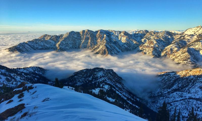
current conditions Should be another beautiful sunny day in the mountains. The inversion over northern Utah will continue to trap the fog, haze and cold air down low. Trailhead temperatures are in the single digits, while the upper elevations are in the mid to upper teens. Winds overnight remained calm and generally from the north with even the highest anemometers only reading 10-15 mph with the occasional gust into the 20's. Sun kissed slopes offer breakable crusts, while the shady slopes have excellent shallow loud powder. Above the inversion - Photo: Trent Meisenheimer
|
 |
recent activity Yesterday backcountry travelers were still reporting sensitive wind slabs along upper elevation ridgelines. These wind slabs were generally about thirty feet wide and up to a foot deep. See Aaron Rice's observation. Provo area mountains on Sunday January 15th: Riders triggered a 3-foot deep, 80-foot wide hard slab mid slope in the northwest chute of Box Elder peak. One person was carried a distance before arresting on the bed surface. This was at 10,200 feet on a northwest-facing slope. |
| type | aspect/elevation | characteristics |
|---|

|

|
LIKELIHOOD
 LIKELY
UNLIKELY
SIZE
 LARGE
SMALL
TREND
 INCREASING DANGER
SAME
DECREASING DANGER
|
|
description
Sensitive wind slabs that formed along ridgelines will be the number one concern today. Identify and avoid the rounded, cracky drifts of harder snow. Even yesterday, the few old wind drifts triggered were large enough to take you for a ride in steep terrain. Brody Leven sent me a video last that demonstrates effective ski cuts in steep terrain. Did I mention he was speaking this Thursday night at Snowbird? |
| type | aspect/elevation | characteristics |
|---|

|
|
LIKELIHOOD
 LIKELY
UNLIKELY
SIZE
LARGE
SMALL
TREND
 INCREASING DANGER
SAME
DECREASING DANGER
|
|
description
In general, we have a stable snow pack and a LOW avalanche danger. But avalanches can still be triggered in isolated places, and even a small slide can have bad consequences if you are in serious terrain. Evaluate steep terrain carefully. Are you above a cliff or in continuous steep terrain where you could go for a long ride? Or be pushed into trees or stopped on a bench where the snow could pile up? Huge cornices are still hanging along the ridgelines, and could break back much further than expected – onto what looks like the flat ridge line. Even if it doesn’t trigger a slide, you could be injured in the fall. Loose snow sluffs can be triggered in the weakening surface snow and are getting large enough to knock you off balance. Wet loose sluffs – a few isolated wet sluffs could be triggered today in steep, sunny terrain. Avoid being in steep sunny terrain during the heat of the day. Wild card – In very isolated places, generally in the high alpine terrain, a deeper slab avalanche could be triggered, perhaps in a shallow rocky snowpack area or on a more heavily wind drifted slope. |
| type | aspect/elevation | characteristics |
|---|

|

|
LIKELIHOOD
LIKELY
UNLIKELY
SIZE
 LARGE
SMALL
TREND
INCREASING DANGER
SAME
DECREASING DANGER
|
|
description
Nerd alert - Have you ever wondered how that feathery snow on the surface develops? or why the skin track becomes slippery? skip to mountain weather if you're in a hurry. Whenever a temperature difference exists in a medium or between media, heat transfer (energy) must occur. This sentence is straight out of my engineering heat transfer book, a class I am currently enrolled in. We refer to different types of heat transfer processes as modes. There are three main modes, conduction, convection and radiation. When a temperature gradient exists in a stationary medium, you will transfer heat or energy. "A temperature gradient is simply how fast temperature changes over a certain distance within the snowpack. Why? Well, the snowpack holds water vapor (gas) and - it's a fact that warm air holds more water vapor than cold air. This means that temperature gradients also create what we call "vapor pressure gradients"--more water vapor in one place than another. And what happens when you concentrate something--especially a gas? It wants to diffuse--move from areas of high concentration to areas of low concentration. When water vapor RAPIDLY diffuses it changes rounded crystals into faceted ones--changes strong snow into weak snow. In other words, temperature gradients create potential weak layers that can kill us. That's why we pay so much attention to them." The skin track gets slippery because this exact process happens right on the surface of the snow. We call it near surface facets. Strong temperature gradients occur in the first few inches of the snowpack and it turns rounded (strong snow) into weak (sugary) faceted snow. Surface hoar or frost (feathery snow) is usually seen in a valley drainage and or creek bottoms. "During a clear sky, the snow in the shade or at night radiates a tremendous amount of heat away and the snow surface becomes very cold. Since we know from earlier in this chapter that warm air holds more water vapor than cold air, the vapor from the warmer air above the snow will condense onto the surface of the snow, and voila, we have surface hoar. Surface hoar (frost) is simply the winter equivalent of dew." This is really important for us to pay attention to over the next few days. With storms on the horizon we need to watch and see if this weak surface snow gets buried and preserved. It could be the next weak layer. Photo of surface hoar from yesterday. Photo: Hardesty & Falk.
|
 |
weather It will be another glorious sunny day in the mountains with temperatures rising into the low 30's at 8500' with upper elevation 10,000' temps rising into the mid 20's. Winds will remain light and generally from the north with speeds of 10-15 mph with the occasional gust into the 20's. Looking ahead - We have a series of small storms expected to impact the state starting on Thursday. None of these storms are looking impressive at this time. However, it will bring a nice refresher to the mountains with 5-10" of new snow possible over a few day period. |
| general announcements Remember your information can save lives. If you see anything we should know about, please help us out by submitting snow and avalanche conditions. You can also call us at 801-524-5304, email by clicking HERE, or include #utavy in your tweet or Instagram. To get help in an emergency (to request a rescue) in the Wasatch, call 911. Be prepared to give your GPS coordinates or the run name. Dispatchers have a copy of the Wasatch Backcountry Ski map. Backcountry Emergencies. It outlines your step-by-step method in the event of a winter backcountry incident. If you trigger an avalanche in the backcountry, but no one is hurt and you do not need assistance, please notify the nearest ski area dispatch to avoid a needless response by rescue teams. Thanks.
EMAIL ADVISORY If you would like to get the daily advisory by email you will need to subscribe here. DAWN PATROL Hotline updated daily by 5-530am - 888-999-4019 option 8. TWITTER Updates for your mobile phone - DETAILS UDOT canyon closures: LINK TO UDOT, or on Twitter, follow @UDOTavy, @CanyonAlerts or @AltaCentral Utah Avalanche Center mobile app - Get your advisory on your iPhone along with great navigation and rescue tools. Powderbird Helicopter Skiing - Blog/itinerary for the day Lost or Found something in the backcountry? - http://nolofo.com/ To those skinning uphill at resorts: it is critical to know the resort policy on uphill travel. You can see the uphill travel policy for each resort here. Benefit the Utah Avalanche Center when you shop from Backcountry.com or REI: Click this link for Backcountry.com or this link to REI, shop, and they will donate a percent of your purchase price to the UAC. Both offer free shipping (with some conditions) so this costs you nothing! Benefit the Utah Avalanche Center when you buy or sell on ebay - set the Utah Avalanche Center as a favorite non-profit in your ebay account here and click on ebay gives when you buy or sell. You can choose to have your seller fees donated to the UAC, which doesn't cost you a penny. This information does not apply to developed ski areas or highways where avalanche control is normally done. This advisory is from the U.S.D.A. Forest Service, which is solely responsible for its content. This advisory describes general avalanche conditions and local variations always exist. |