25th Annual Black Diamond Fall Fundraising Party
Thursday, September 13; 6:00-10:00 PM; Black Diamond Parking Lot
25th Annual Black Diamond Fall Fundraising Party
Thursday, September 13; 6:00-10:00 PM; Black Diamond Parking Lot
| Advisory: Salt Lake Area Mountains | Issued by Evelyn Lees for Friday - December 2, 2016 - 6:46am |
|---|

|
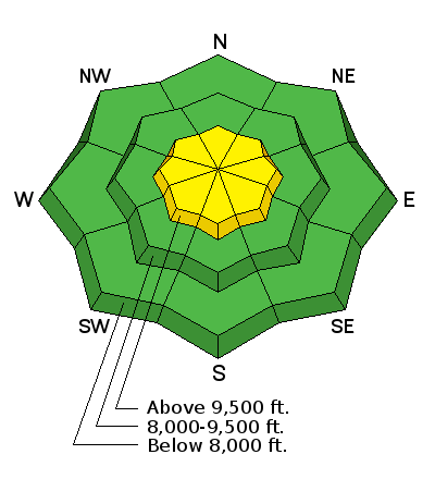
bottom line Avalanche danger is MODERATE on steep upper elevation slopes facing northwest, north and northeast, where a slide breaking to the ground could be triggered. There is also on MODERATE danger at the upper elevations on any slope where new drifts of wind blown snow have formed. The consequences of getting caught in any avalanche in our thin, early-season snowpack means taking a ride over rocks and deadfall.
|
 |
special announcement Please read, please share with others - UAC/UDOT Comms plan: New Avalanche Explosives Work Backcountry Closure Procedures Going Into Effect |
 |
current conditions Skies are mostly cloudy, with light snow still falling at the upper elevations. The upper elevations have received anywhere from zero to four inches of fluffy snow in the last 24 hours. Temperatures continue to be cold, and are in the single digits and low teens this morning. Winds are light, averaging 5 to 15 mph from a northeasterly direction, but starting to gust in the 20s at the higher elevations. Clouds and cold temperatures have kept the snow powdery on all aspects. This week’s storm opened up a lot of terrain, but it’s still a shallow, early season snow pack – around 3 feet at the upper elevations, but only 12 to 18” at the mid and low elevations and most trail heads. |
 |
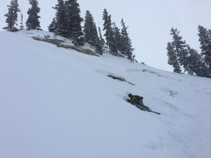
recent activity Drew checked out Wednesday’s skier triggered avalanche in the East Bowl of Silver Fork – it failed on large facets sitting on a rock slab in a shallow snowpack area. Observation HERE. |
| type | aspect/elevation | characteristics | ||
|---|---|---|---|---|

|
|
LIKELIHOOD
 LIKELY
UNLIKELY
SIZE
 LARGE
SMALL
TREND
 INCREASING DANGER
SAME
DECREASING DANGER
|
||
|
description
The early season snow that lingered on northwest, north and northeasterly facing slopes formed a faceted layer of snow on the ground. Avalanches have been triggered on the layer, and it remains suspect. The best solution is to avoid steep slopes (about 35 degrees or steeper) on this aspect and elevation – north, northeast and northwesterly facing slopes above about 9,500’, especially those with smooth rock or grass beneath. Great powder exists around the compass on other aspects and elevations. Below are all of yesterday's backcountry observations, with great photos and videos showing the facets of the ground.
|
| type | aspect/elevation | characteristics |
|---|

|
|
LIKELIHOOD
LIKELY
UNLIKELY
SIZE
 LARGE
SMALL
TREND
 INCREASING DANGER
SAME
DECREASING DANGER
|
|
description
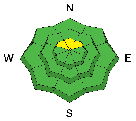
Keep a sharp eye on the wind speeds – even a small increase where you are traveling will start to drift snow, forming Wind Slabs. Denser, cracky snow indicates a sensitive wind slab – avoid all wind drifts on steep slopes, which will be most widespread along the higher ridge lines. With the more unusual northeasterly wind direction, look for drifts in odd places that you are not used to. Even as we drop toward LOW danger on many slopes, make sure everyone in your backcountry party has avalanche gear, do a training session, and follow low risk travel procedures – including one at a time on steep slopes. |
 |
weather Expect another cool day in the mountains, with mostly cloudy skies and a few snow flurries this morning. Temperatures will warm into the mid 20s at 8,000’ and into the low teens at 10,000’. The winds are generally from the northeast, and should average less than 15 mph, though the highest peaks and ridges may have gusts to 30 mph. High pressure will build in tonight, and Saturday should be clear and sunny. The next storm approaches Sunday night, with a strong front, gusty winds and cold air dropping temperatures well below zero by Monday. |
| general announcements Remember your information can save lives. If you see anything we should know about, please help us out by submitting snow and avalanche conditions. You can also call us at 801-524-5304, email by clicking HERE, or include #utavy in your tweet or Instagram. To get help in an emergency (to request a rescue) in the Wasatch, call 911. Be prepared to give your GPS coordinates or the run name. Dispatchers have a copy of the Wasatch Backcountry Ski map. Backcountry Emergencies. It outlines your step-by-step method in the event of a winter backcountry incident. If you trigger an avalanche in the backcountry, but no one is hurt and you do not need assistance, please notify the nearest ski area dispatch to avoid a needless response by rescue teams. Thanks.
EMAIL ADVISORY If you would like to get the daily advisory by email you will need to subscribe here. DAWN PATROL Hotline updated daily by 5-530am - 888-999-4019 option 8. TWITTER Updates for your mobile phone - DETAILS UDOT canyon closures: LINK TO UDOT, or on Twitter, follow @UDOTavy, @CanyonAlerts or @AltaCentral Utah Avalanche Center mobile app - Get your advisory on your iPhone along with great navigation and rescue tools. Powderbird Helicopter Skiing - Blog/itinerary for the day Lost or Found something in the backcountry? - http://nolofo.com/ To those skinning uphill at resorts: it is critical to know the resort policy on uphill travel. You can see the uphill travel policy for each resort here. Benefit the Utah Avalanche Center when you shop from Backcountry.com or REI: Click this link for Backcountry.com or this link to REI, shop, and they will donate a percent of your purchase price to the UAC. Both offer free shipping (with some conditions) so this costs you nothing! Benefit the Utah Avalanche Center when you buy or sell on ebay - set the Utah Avalanche Center as a favorite non-profit in your ebay account here and click on ebay gives when you buy or sell. You can choose to have your seller fees donated to the UAC, which doesn't cost you a penny.
|


 This information does not apply to developed ski areas or highways where avalanche control is normally done. This advisory is from the U.S.D.A. Forest Service, which is solely responsible for its content. This advisory describes general avalanche conditions and local variations always exist.