25th Annual Black Diamond Fall Fundraising Party
Thursday, September 13; 6:00-10:00 PM; Black Diamond Parking Lot
25th Annual Black Diamond Fall Fundraising Party
Thursday, September 13; 6:00-10:00 PM; Black Diamond Parking Lot
| Advisory: Salt Lake Area Mountains | Issued by Drew Hardesty for Thursday - November 24, 2016 - 5:57am |
|---|

|
bottom line The morning starts out Considerable for human triggered avalanches in steep wind-drifted terrain...with the trend toward Moderate as the day wears on. The danger will be most pronounced in the upper elevations and particularly in northerly (NW-N-NE) terrain where avalanches may step down to the ground. Careful analysis and route-finding will be required today if traveling in avalanche terrain. Remember that we often have early season accidents and involvements as powder-fever tends to over-rule rational, conservative decision-making. Remember that the traumatic injury is likely with any incident due to the still-thin coverage.
|
 |
special announcement Alta and Snowbird are closed to uphill traffic as they get their resort ready for daily operations. The summer road into Albion Basin to the Catherine's area and Grizzly Gulch remains open. Generally speaking, if you're heading to a ski area please check in with the individual ski resort and find out their uphill traffic policies. If you walk up one ski area with another adjacent to it, please respect and check in with the sister resort before riding down into their resort. More info and links to the resorts here. Between now and Jan 15th: Donate to the Utah Avalanche Center by shopping at Whole Foods Market Utah! when you visit Whole Foods Market Trolley Square, Sugarhouse & Cottonwood Heights locations and bring in your re-usable bags, Whole Foods will donate a dime per bag to Utah Avalanche Center when the cashier asks if you want to “keep or donate” your bag credit and you say “DONATE". |
 |
current conditions This storm was no turkey. (Sorry about that.) The cold front moved in like a freight train around dinnertime last night with at-times snowfall rates in the 1, 2, even 3 inches per hour. This all added up to about a foot of snow (12"/.91 as of 5am) in the upper Cottonwoods and 5-10" along the Park City ridgeline (better numbers along the north end). One to two feet of snow now exists in non-drifted terrain, allowing for fair, if tentative, travel. Mind the still thinly veiled rocks, stumps, and deadfall. Skies are clearing. Temps have plummeted to the upper single digits and low teens up high, the upper teens to low 20s down low. Gustiest during and just after frontal passage, the west-northwest winds are now generally less than 15mph. |
 |
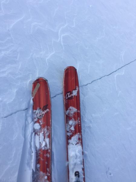
recent activity The moderate to strong southwesterly winds yesterday developed some new stiff and stubborn drifts and I was able to crack one out 4-8" deep and perhaps 50' wide on a steeper rollover in upper elevation northeast facing terrain. It was a hard wind slab that wasn't able to buckle out at the bottom, but gave clear signs of avalanche trouble for wind drifted terrain. Remember that - in general - soft slabs you're in the slab, for hard slabs you remain on top. See pic below. There will likely be both out there today.
|
| type | aspect/elevation | characteristics |
|---|

|
|
LIKELIHOOD
 LIKELY
UNLIKELY
SIZE
 LARGE
SMALL
TREND
 INCREASING DANGER
SAME
DECREASING DANGER
|
|
description
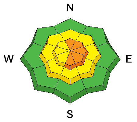
New and older, hard wind drifts will dot the landscape both just to the lee of the ridgelines and well down off the ridgelines and should be sensitive to human interaction. Adding some complexity are yesterday's winds which alternated loading some and scouring other starting zones. Which are which? - They'll be buried by last night's snow - it'll be hard to tell. Hot Tip - Cracking and collapsing are sure signs of localized instability. Note: conditions will likely improve as the day wears on. |
| type | aspect/elevation | characteristics |
|---|

|
|
LIKELIHOOD
LIKELY
UNLIKELY
SIZE
LARGE
SMALL
TREND
INCREASING DANGER
SAME
DECREASING DANGER
|
|
description
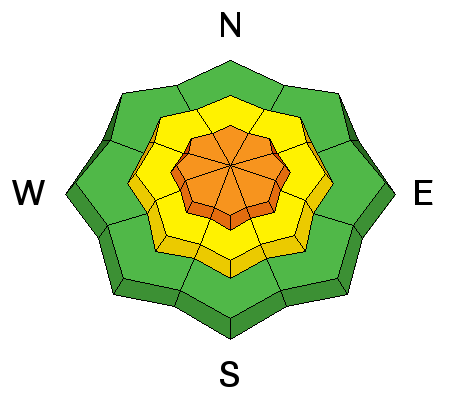
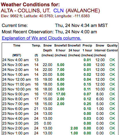
Avalanche instability corresponds directly with what we call deformation rates. Silly putty has long been used by avalanche educators to describe the visco-elastic properties of snow. Pull the silly putty slowly apart (slow deformation), and it can bend and stretch....pull the silly putty quickly (rapid deformation) and it snaps...and well, you get the idea. The rapid deformation for the snow corresponds to loading rates and you can refer to the Collins weather station screen-shot at Alta, below. In this case, you see snowfall rates of 1, 2, even 3 inches per hour. This - along with additional loading by wind - and avalanches tend to follow in lock-step. Note: conditions will likely improve as the day wears on.
|
| type | aspect/elevation | characteristics |
|---|

|
|
LIKELIHOOD
 LIKELY
UNLIKELY
SIZE
 LARGE
SMALL
TREND
 INCREASING DANGER
SAME
DECREASING DANGER
|
|
description
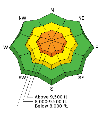
Interesting to note that yesterday's hard wind slab remained within the new snow and did not step down into the older underlying weak faceted snow near the ground. Cody Hughes snowpit below shows the weak snow, below. The grey, coarse faceted grains remain quite weak in specific terrain. With last night's additional loading, any avalanches triggered today in steep northwest through north through northeast facing terrain above 9500' may have the potential to step to the ground with this layering.
|
 |
weather We'll have clearing skies, mountain temps in the low 20s, and 15mph winds from the west and northwest. Ridging moves in, albeit briefly, ahead of another large scale storm impacting the intermountain west starting late Saturday through Tuesday. It looks to be a southern Utah special, but we may potentially see another decent foot of snow over that time period. In the meantime, temps will warm toward freezing at 10,000' later tomorrow with increasing southwest to south winds tomorrow through Saturday. |
| general announcements Remember your information can save lives. If you see anything we should know about, please help us out by submitting snow and avalanche conditions. You can also call us at 801-524-5304, email by clicking HERE, or include #utavy in your tweet or Instagram. To get help in an emergency (to request a rescue) in the Wasatch, call 911. Be prepared to give your GPS coordinates or the run name. Dispatchers have a copy of the Wasatch Backcountry Ski map. Backcountry Emergencies. It outlines your step-by-step method in the event of a winter backcountry incident. If you trigger an avalanche in the backcountry, but no one is hurt and you do not need assistance, please notify the nearest ski area dispatch to avoid a needless response by rescue teams. Thanks.
EMAIL ADVISORY If you would like to get the daily advisory by email you will need to subscribe here. DAWN PATROL Hotline updated daily by 5-530am - 888-999-4019 option 8. TWITTER Updates for your mobile phone - DETAILS UDOT canyon closures: LINK TO UDOT, or on Twitter, follow @UDOTavy, @CanyonAlerts or @AltaCentral Utah Avalanche Center mobile app - Get your advisory on your iPhone along with great navigation and rescue tools. Powderbird Helicopter Skiing - Blog/itinerary for the day Lost or Found something in the backcountry? - http://nolofo.com/ To those skinning uphill at resorts: it is critical to know the resort policy on uphill travel. You can see the uphill travel policy for each resort here. Benefit the Utah Avalanche Center when you shop from Backcountry.com or REI: Click this link for Backcountry.com or this link to REI, shop, and they will donate a percent of your purchase price to the UAC. Both offer free shipping (with some conditions) so this costs you nothing! Benefit the Utah Avalanche Center when you buy or sell on ebay - set the Utah Avalanche Center as a favorite non-profit in your ebay account here and click on ebay gives when you buy or sell. You can choose to have your seller fees donated to the UAC, which doesn't cost you a penny.
|


 This information does not apply to developed ski areas or highways where avalanche control is normally done. This advisory is from the U.S.D.A. Forest Service, which is solely responsible for its content. This advisory describes general avalanche conditions and local variations always exist.