| Please join us at the 23rd annual Black Diamond Fall Fundraiser Party Thursday Sept 15. Tickets are on sale now here, at the Black Diamond store & at REI. Special bonus raffle for online ticket purchasers! |
| Please join us at the 23rd annual Black Diamond Fall Fundraiser Party Thursday Sept 15. Tickets are on sale now here, at the Black Diamond store & at REI. Special bonus raffle for online ticket purchasers! |
| Advisory: Salt Lake Area Mountains | Issued by Mark Staples for Saturday - March 5, 2016 - 5:58am |
|---|

|
bottom line The avalanche danger today is LOW. In isolated areas watch for unstable snow which can be loose wet snow avalanches, glide avalanches, or falling cornices.
|
 |
special announcement The Wasatch Powderkeg is going on this weekend at Brighton Resort. We are offering on-snow clinics to help refresh your mountain skills or learn new ones. This is a great way to prepare yourself and your partners for those big spring objectives! Click here for the full list of clinics and event details. Voile, La Sportiva, Scarpa and Camp will all be offering free gear demos! The Utah Avalanche Center greatly values our longtime partnership with our world-class resorts and is blowing out the remaining donated lift tickets from Snowbird, Snowbasin, Sundance, and Nordic Valley with reduced prices. Every penny you spend benefits the Utah Avalanche Center. Check out our Garage Sale! Chock full of sweet backcountry gear - you can find the goods on our Facebook page here. |
 |
current conditions Air temperatures did not drop below freezing overnight, and temperatures this morning are in the mid to high 30's F. High temperatures yesterday reached the 50's F in many places. Ridgetop winds increased last night around 10 p.m. and are blowing 15 mph gusting to 30 mph from the south. Good corn snow has been reported on south aspects, but I'm unsure what it will be like this morning with some clouds and above freezing temperatures overnight. Low elevations likely have unsupportable wet snow and poor riding conditions. |
 |
recent activity There were no reports of avalanches from the backcountry yesterday. |
| type | aspect/elevation | characteristics |
|---|

|
|
LIKELIHOOD
 LIKELY
UNLIKELY
SIZE
 LARGE
SMALL
TREND
 INCREASING DANGER
SAME
DECREASING DANGER
|
|
description
The main issue continues to be warm temperatures and the lack of a refreeze overnight. Often clear skies can allow the snowpack to refreeze even if air temperatures are above freezing, but skies were at least partially cloudy overnight. The snowpack should be pretty wet this morning. Today will have some clouds which will limit heating due to sunshine but strong winds and warm air will provide plenty of heat to the snowpack. Conditions are not too complicated. For stable snow, look for solid, supportable snow. At upper elevations, either go to north facing slopes with dry snow or south facing slopes where the snow is only wet near the surface. With increased winds there is a chance to find a few very shallow wind slabs as Evelyn found on Wednesday above Grizzly Gulch near Alta. At lower elevations, avoid avalanche terrain in any area where the snowpack is mostly wet and unsupportable. Lastly watch for glide avalanches where the snowpack sits on smooth rock slabs, including Stairs Gulch, Broads Fork, and Mill B South of Big Cottonwood Canyon, and old cornices that can break further back from the edge than expected. Its best to avoid traveling under either of these problems. |
 |
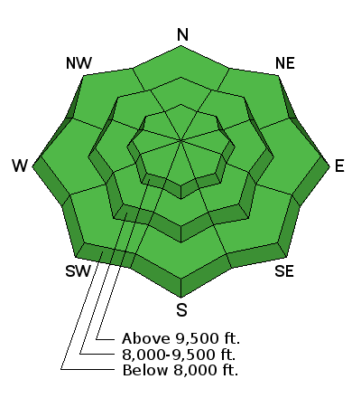
weather Today should be warm and windy with some clouds. Temperatures should climb into the 40's F again and break 50 degrees F in places. Winds should blow 15-20 mph from the south with gusts of 30 mph. Tonight a trace to an inch of snow should fall above 8000 feet. Much more snow should come Sunday and Sunday night with about a foot of snow falling by Monday morning. The total amount of snow depends on how much falls after the cold front passes over the area. |
| general announcements Remember your information can save lives. If you see anything we should know about, please help us out by submitting snow and avalanche conditions. You can also call us at 801-524-5304, email by clicking HERE, or include #utavy in your tweet or Instagram. To get help in an emergency (to request a rescue) in the Wasatch, call 911. Be prepared to give your GPS coordinates or the run name. Dispatchers have a copy of the Wasatch Backcountry Ski map. Backcountry Emergencies. It outlines your step-by-step method in the event of a winter backcountry incident. If you trigger an avalanche in the backcountry, but no one is hurt and you do not need assistance, please notify the nearest ski area dispatch to avoid a needless response by rescue teams. Thanks.
EMAIL ADVISORY If you would like to get the daily advisory by email you will need to subscribe here. DAWN PATROL Hotline updated daily by 5-530am - 888-999-4019 option 8. TWITTER Updates for your mobile phone - DETAILS UDOT canyon closures: LINK TO UDOT, or on Twitter, follow @UDOTavy, @CanyonAlerts or @AltaCentral Utah Avalanche Center mobile app - Get your advisory on your iPhone along with great navigation and rescue tools. Powderbird Helicopter Skiing - Blog/itinerary for the day Lost or Found something in the backcountry? - http://nolofo.com/ To those skinning uphill at resorts: it is critical to know the resort policy on uphill travel. You can see the uphill travel policy for each resort here. Benefit the Utah Avalanche Center when you shop from Backcountry.com or REI: Click this link for Backcountry.com or this link to REI, shop, and they will donate a percent of your purchase price to the UAC. Both offer free shipping (with some conditions) so this costs you nothing! Benefit the Utah Avalanche Center when you buy or sell on ebay - set the Utah Avalanche Center as a favorite non-profit in your ebay account here and click on ebay gives when you buy or sell. You can choose to have your seller fees donated to the UAC, which doesn't cost you a penny.
|


 This information does not apply to developed ski areas or highways where avalanche control is normally done. This advisory is from the U.S.D.A. Forest Service, which is solely responsible for its content. This advisory describes general avalanche conditions and local variations always exist.