| Please join us at the 23rd annual Black Diamond Fall Fundraiser Party Thursday Sept 15. Tickets are on sale now here, at the Black Diamond store & at REI. Special bonus raffle for online ticket purchasers! |
| Please join us at the 23rd annual Black Diamond Fall Fundraiser Party Thursday Sept 15. Tickets are on sale now here, at the Black Diamond store & at REI. Special bonus raffle for online ticket purchasers! |
| Advisory: Salt Lake Area Mountains | Issued by Mark Staples for Monday - December 21, 2015 - 5:59am |
|---|


|
bottom line The snowpack has been producing avalanches and giving warning signs since last Thursday. New snow since yesterday has created dangerous avalanche conditions and the avalanche danger is HIGH on upper elevation slopes with wind drifted snow. Other slopes are very close to their breaking point and have a CONSIDERABLE avalanche danger. Heavy snow will arrive this afternoon and the avalanche danger will be increasing.
|
 |
avalanche watch THE FOREST SERVICE UTAH AVALANCHE CENTER IN SALT LAKE CITY HAS CONTINUED A BACKCOUNTRY AVALANCHE WATCH. * TIMING…MONDAY...THEN TRANSITIONING TO AN AVALANCHE WARNING THIS AFTERNOON. * AFFECTED AREA…ALL THE MOUNTAINS OF NORTHERN UTAH AND SOUTHEASTERN IDAHO, TO INCLUDE THE WASATCH RANGE, THE BEAR RIVER RANGE, THE WESTERN UINTAS AND THE MANTI-SKYLINE PLATEAU. * AVALANCHE DANGER…EXPECTED HEAVY SNOW AND STRONG WIND WILL PUSH THE DANGER TO HIGH AND PERHAPS EXTREME OVER THE NEXT SEVERAL DAYS. * IMPACTS…BY LATER MONDAY INTO TUESDAY, LARGE AND DANGEROUS NATURAL AND HUMAN TRIGGERED AVALANCHES WILL BE LIKELY. AVOID BEING IN STEEP TERRAIN OR BENEATH AVALANCHE RUNOUT ZONES. THIS WARNING DOES NOT APPLY TO SKI AREAS WHERE AVALANCHE HAZARD REDUCTION MEASURES ARE PERFORMED
Avalanche Watch and Warnings from Trent Meisenheimer on Vimeo. |
 |
special announcement Interested in going to one of our world class ski resorts? Buy discount lift tickets to Utah resorts and benefit the Utah Avalanche Center! Details here |
 |
current conditions This morning mountain temperatures were in mid-teens F above 9000 feet. Winds were blowing 15 mph gusting to 25 mph mostly from the west at elevations above 8000 feet. Near Alta, there wasn't much difference between winds at 10,000 feet and winds at 8000 feet. Since yesterday upper Little Cottonwood Canyon received 9 inches of snow (0.6 inches of SWE) while upper Big Cottonwood received 16 inches of snow (0.9 inches of SWE). The Park City side received 8-10 inches of snow. A freezing rain/rime/etc crust formed Friday morning. It is a thick ice crust after melting and refreezing on S aspects and remains a fragile crust on N aspects. |
 |
recent activity Yesterday the only avalanche activity was loose snow sluffs running on top of Friday's crust. The snowpack throughout Utah is fairly similar and it has given us warning signs worth paying attention to.
|
| type | aspect/elevation | characteristics |
|---|

|
|
LIKELIHOOD
 LIKELY
UNLIKELY
SIZE
 LARGE
SMALL
TREND
 INCREASING DANGER
SAME
DECREASING DANGER
|
|
description
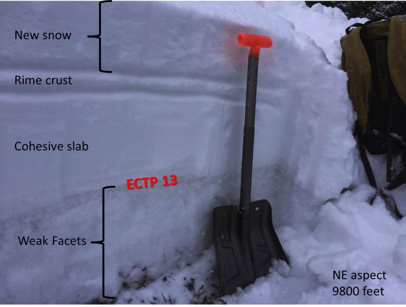
There is weak, faceted snow near the ground mostly on NW through E aspects; however, similar facets exist between ice crusts on other aspects. Human triggered avalanches have occurred on Thursday, Friday, Saturday, and Sunday on these faceted layers. While these avalanches have occurred in different parts of Utah, the snowpack is fairly similar in most areas and these slides are a good warning sign. Additionally there have been steady reports from observers experiencing collapsing of the snowpack. Feeling a collapse of the snowpack and hearing a whumpfing sound tells you that weak facets near the ground fractured and you will trigger an avalanche if you get on or near a slope steeper than 30 degrees. The most likely place to trigger or see a persistent slab avalanche will be on wind loaded, upper elevation slopes facing NW through E. However, even non wind-loaded slopes may be near their breaking point and only need a human trigger to produce an avalanche. I was on a NE facing slope without a wind-load at 9800 feet yesterday and got unstable results in stability tests. You can clearly see the weak facets in the photo below. Trent was nearby in Mineral Fork and got similar results.
|
| type | aspect/elevation | characteristics |
|---|

|
|
LIKELIHOOD
 LIKELY
UNLIKELY
SIZE
 LARGE
SMALL
TREND
INCREASING DANGER
SAME
DECREASING DANGER
|
|
description
Winds this morning in upper Little Cottonwood Canyon were blowing 15-25 mph at all elevations. These winds will transport the new snow and form wind slabs which will be easy to trigger today. They should be resting on the low density new snow which will be the weak layer on which these wind slabs will fracture. Friday's crust underneath the new snow should allow these wind slabs to run farther downhill than that would normally. The scary part about triggering a wind slab today is that there is a good chance it will step down and cause a larger avalanche breaking on facets near the ground. |
 |
weather Yesterday's storm will move east this morning and there will be a brief break in the storms around midday. Later today the next storm should arrive with a lot more precipitation and stronger winds through Tuesday morning. This storm will begin with fairly warm temperatures which will followed by colder air on Tuesday. Another 2-4 inches of snow should fall this morning before the storm exits the area. Temperatures should warm today as the storm approaches reaching the upper 20s F. Winds should continue blowing 15-25 mostly from the west and shift to the southwest. |
| general announcements Remember your information can save lives. If you see anything we should know about, please participate in the creation of our own community avalanche advisory by submitting snow and avalanche conditions. You can also call us at 801-524-5304, email by clicking HERE, or include #utavy in your tweet or Instagram. To get help in an emergency (to launch a rescue) in the Wasatch, call 911. Be prepared to give your GPS coordinates or the run name. Dispatchers have a copy of the Wasatch Backcountry Ski map. Backcountry Emergencies. It outlines your step-by-step method in the event of a winter backcountry incident. If you trigger an avalanche in the backcountry, but no one is hurt and you do not need assistance, please notify the nearest ski area dispatch to avoid a needless response by rescue teams. Thanks. Salt Lake and Park City – Alta Central (801-742-2033), Canyons Resort/PCMR Dispatch (435)615-1911 Snowbasin Resort Dispatch (801-620-1017), Powder Mountain Dispatch (801-745-3772 x 123). Sundance Dispatch (801-223-4150) EMAIL ADVISORY If you would like to get the daily advisory by email you will need to subscribe here. DAWN PATROL Hotline updated daily by 5-530am - 888-999-4019 option 8. Twitter Updates for your mobile phone - DETAILS UDOT canyon closures: LINK TO UDOT, or on Twitter, follow @UDOTavy, @CanyonAlerts or @AltaCentral Utah Avalanche Center mobile app - Get your advisory on your iPhone along with great navigation and rescue tools. Powderbird Helicopter Skiing - Blog/itinerary for the day Lost or Found something in the backcountry? - http://nolofo.com/ To those skinning uphill at resorts: it is your responsibility to know the resort policy on uphill travel. You can see the uphill travel policy for each resort here. IMPORTANT: Before skinning or hiking at a resort under new snow conditions, check in with Ski Patrol. Resorts can restrict or cut off access if incompatible with control and grooming operations. Benefit the Utah Avalanche Center when you shop from Backcountry.com or REI: Click this link for Backcountry.com or this link to REI, shop, and they will donate a percent of your purchase price to the UAC. Both offer free shipping (with some conditions) so this costs you nothing! Benefit the Utah Avalanche Center when you buy or sell on ebay - set the Utah Avalanche Center as a favorite non-profit in your ebay account here and click on ebay gives when you buy or sell. You can choose to have your seller fees donated to the UAC, which doesn't cost you a penny. This information does not apply to developed ski areas or highways where avalanche control is normally done. This advisory is from the U.S.D.A. Forest Service, which is solely responsible for its content. This advisory describes general avalanche conditions and local variations always exist. |