
| During the month of April, Mark Miller will donate $75 to the charity of your choice (5 to chose from, including the Utah Avalanche Center!) Mark Miller Subaru has raised over $300k in the previous 6 Do Good Feel Good events. More Info here |  |
| During the month of April, Mark Miller will donate $75 to the charity of your choice (5 to chose from, including the Utah Avalanche Center!) Mark Miller Subaru has raised over $300k in the previous 6 Do Good Feel Good events. More Info here | |
| Advisory: Salt Lake Area Mountains | Issued by Bruce Tremper for Monday - February 9, 2015 - 6:11am |
|---|

|
bottom line The danger today is mostly LOW. But IF we get more than the 1-2 inches of new snow forecast or the wind does not drop with the arrival of the cold front, expect a MODERATE danger of wind slabs and storm snow instabilities.
|
 |
current conditions Today is the 36th day in a row of above normal temperatures in Salt Lake City with more days like it in the forecast. It's balmy and warm this morning again with strong wind along the ridge tops in advance of yet another weak cold front scheduled to arrive mid day. At 9,000' it's 34 this morning with the ridge top wind blowing 30, gusting to 50 from the southeast. Snow surface conditions yesterday were surprisingly good on the northerly facing, wind-sheltered slopes with 2-5 inches of soft, dry, faceted snow and settled old snow. The sun exposed aspects will likely be crusted today. The wind exposed terrain has a wide variety of sastrugi and old, smooth wind slabs. |
 |
recent activity No significant activity reported from yesterday. |
| type | aspect/elevation | characteristics |
|---|

|

|
LIKELIHOOD
 LIKELY
UNLIKELY
SIZE
 LARGE
SMALL
TREND
 INCREASING DANGER
SAME
DECREASING DANGER
|
|
description
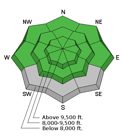
Today, the forecast is for 1-2 inches of new snow from a weak, quick-hitting cold front expected to arrive around mid day. The wind is supposed to blow hard before the arrival of the front, but there is not much snow to blow around and the wind is supposed to drop as soon as the new snow begins. So, in theory, it shouldn't change the avalanche conditions very much unless we get much more snow or post-frontal wind than forecast. Watch for all the usual problems with new snow including recent deposits of wind blown snow on steep slopes and any instabilities within the new snow. Since everything will be right on the surface, it's easy to test the snow continuously as you travel by jumping on small test slopes and digging with your hand. Note: the danger rose is blank on the southerly facing slopes below 8,000' because it's mostly bare ground. |
 |
weather Balmy, windy weather this morning will be punctuated by a weak, quick-hitting, cold front by about mid day. The forecast is for 1-2 inches of snow and the wind should drop with the arrival of the cold front. Then, a few lingering clouds this afternoon and evening. This morning, expect temperatures in the mid to upper 30's with ridge top wind from the south 30, gusting to 50. The cold front should drop temperatures in to the lower 20's and the wind should drop as well and turn westerly, then northerly by tonight. After cooler temperatures and perhaps some scattered clouds on Tuesday, we should return to warmer temperatures by Wednesday. Unfortunately, we still don't see any significant snow in the forecast. |
| general announcements
Remember your information can save lives. If you see anything we should know about, please participate in the creation of our own community avalanche advisory by submitting snow and avalanche conditions. You can also call us at 801-524-5304, email by clicking HERE, or include #utavy in your tweet or Instagram. If you trigger an avalanche in the backcountry - especially if you are adjacent to a ski area – please call the following teams to alert them to the slide and whether anyone is missing or not. Rescue teams can be exposed to significant hazard when responding to avalanches, and do not want to do so when unneeded. Thanks. Salt Lake and Park City – Alta Central (801-742-2033), Canyons Resort Dispatch (435-615-3322) Snowbasin Resort Dispatch (801-620-1017), Powder Mountain Dispatch (801-745-3772 x 123). Sundance Dispatch (801-223-4150) EMAIL ADVISORY If you would like to get the daily advisory by email you will need to subscribe here. DAWN PATROL Hotline updated daily by 5-530am - 888-999-4019 option 8. Twitter Updates for your mobile phone - DETAILS UDOT canyon closures: LINK TO UDOT, or on Twitter, follow @UDOTavy, @CanyonAlerts or @AltaCentral Utah Avalanche Center mobile app - Get your advisory on your iPhone along with great navigation and rescue tools. Wasatch Powderbird Guides Blog/Itinerary for the Day. Lost or Found something in the backcountry? - http://nolofo.com/ Discount lift tickets are now available at Backcountry.com. Thanks to Ski Utah and the Utah Resorts. All proceeds go towards paying for Utah Avalanche Center avalanche and mountain weather advisories. To those skinning uphill at resorts: it is your responsibility to know the resort policy on uphill travel. You can see the uphill travel policy for each resort here. IMPORTANT: Before skinning or hiking at a resort under new snow conditions, check in with Ski Patrol. Resorts can restrict or cut off access if incompatible with control and grooming operations. Benefit the Utah Avalanche Center when you shop from Backcountry.com or REI: Click this link for Backcountry.com or this link to REI, shop, and they will donate a percent of your purchase price to the UAC. Both offer free shipping (with some conditions) so this costs you nothing! Benefit the Utah Avalanche Center when you buy or sell on ebay - set the Utah Avalanche Center as a favorite non-profit in your ebay account here and click on ebay gives when you buy or sell. You can choose to have your seller fees donated to the UAC, which doesn't cost you a penny. This information does not apply to developed ski areas or highways where avalanche control is normally done. This advisory is from the U.S.D.A. Forest Service, which is solely responsible for its content. This advisory describes general avalanche conditions and local variations always exist. |


