| During the month of April, Mark Miller will donate $75 to the charity of your choice (5 to chose from, including the Utah Avalanche Center!) Mark Miller Subaru has raised over $300k in the previous 6 Do Good Feel Good events. More Info here |  |
| During the month of April, Mark Miller will donate $75 to the charity of your choice (5 to chose from, including the Utah Avalanche Center!) Mark Miller Subaru has raised over $300k in the previous 6 Do Good Feel Good events. More Info here | |
| Advisory: Salt Lake Area Mountains | Issued by Bruce Tremper for Sunday - January 18, 2015 - 5:57am |
|---|


|
bottom line The avalanche danger is mostly LOW but there are pockets of MODERATE danger for wind slabs on any steep slope with recent wind deposits (which usually look smooth and rounded) and also pockets of lingering, persistent slabs in wind and sun-sheltered terrain.
|
 |
special announcement AvaTech-SheJumps Happy Hour |
 |
current conditions With high and mid level clouds today, it won't be the spectacular day we enjoyed yesterday. The wind has picked up again from the west and southwest 30, gusting to 40 along the high elevation, exposed terrain. It's warm, with temperatures near freezing this morning. The snow surface conditions include a wide variety of sun and wind crusts at all aspects and elevations with the notable exception of some good, dry, settled powder and recrystallized snow in the north facing, wind sheltered terrain. |
 |
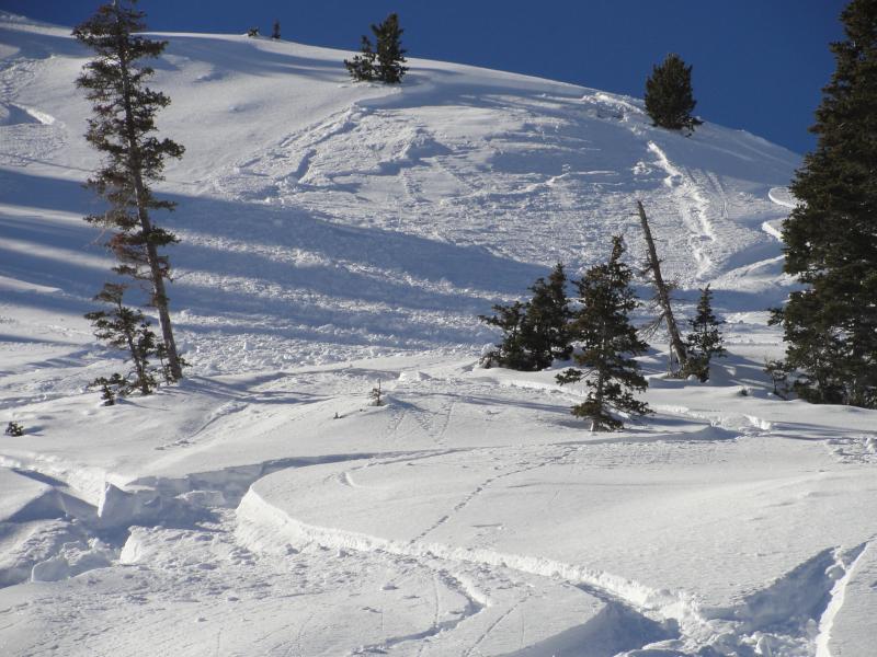
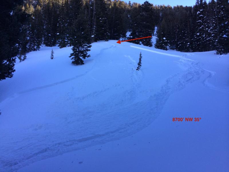
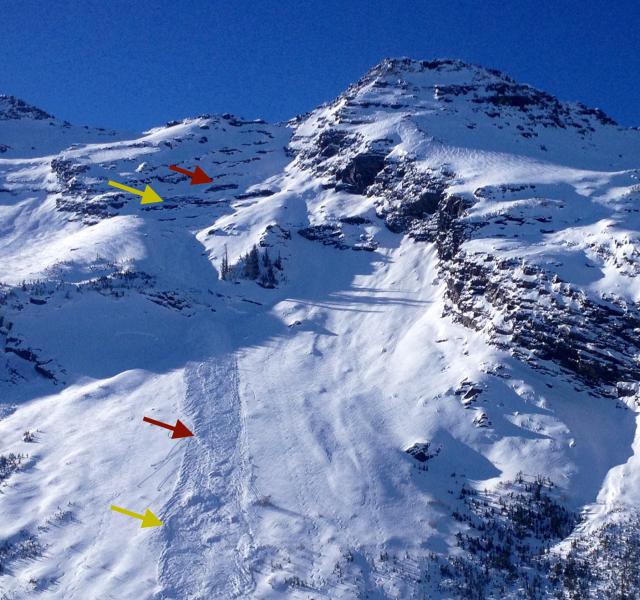
recent activity Very experienced skiers triggered three different soft slab avalanches yesterday on persistent weak layers. One was a wind slab (Peak 10,420) and two others were not wind affected (Thaynes Canyon in Mill Creek and Lambs Canyon). Plus, there was yet another small glide avalanche in Broad's Fork. Although most popular slopes are filled with tracks throughout the Wasatch Range, there's still some localized mischief out there. (Click on the image or the links for the compete observation.)
|
| type | aspect/elevation | characteristics |
|---|

|

|
LIKELIHOOD
 LIKELY
UNLIKELY
SIZE
 LARGE
SMALL
TREND
 INCREASING DANGER
SAME
DECREASING DANGER
|
|
description
The wind blew hard a couple nights ago and again last night from the west and southwest. So be cautious of recent deposits of wind drifted snow, which you will find mostly on east facing slopes in upper elevation wind exposed terrain but also in many other areas as well. It's easy to identify wind slabs by their smooth, rounded shape and they sometimes sound hollow or will crack beneath you. They range from soft to hard. |
| type | aspect/elevation | characteristics |
|---|

|

|
LIKELIHOOD
LIKELY
UNLIKELY
SIZE
LARGE
SMALL
TREND
INCREASING DANGER
SAME
DECREASING DANGER
|
|
description
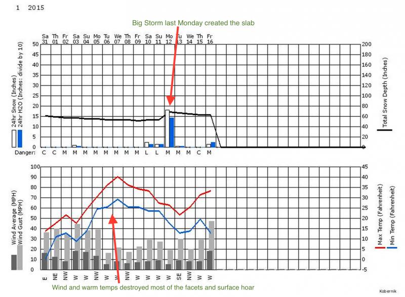
It seems that our old friend, persistent slab, is back in the forecast as yesterday three very experienced skiers triggered avalanches and in their investigation they confirmed that they slid on a persistent weak layer of either near surface faceted snow or surface hoar. This layer formed during the first part of January on the snow surface but the very warm temperatures and wind destroyed most of it with the exception of some wind sheltered, shady terrain. Then, last Monday's wild storm gave us a couple of feet of dense snow that formed the slab on top. Unfortunately, there's still some lingering, localized mischief out there to keep us on our toes.
Here's the weather for January that probably produced the pockets of lingering persistent weak layers.
|
 |
weather Today will not be the spectacular weather we had yesterday. Yes, it should be warm again, 30 to 40 degrees, but high and mid elevation clouds the first half of the day will cast more of a gloom over the mountains and we may get scattered sun and clouds this afternoon. Plus, the wind has picked up once again and it should continue to blow 30, gusting to 50 from the west in the exposed, upper elevation terrain. Monday, we should see even more clouds with the chance of a snowflake or two but no significant accumulation. The extended forecast, unfortunately, looks bleak with warm temperature no significant snow for perhaps 10 more days. Yuck. |
| general announcements Remember your information can save lives. If you see anything we should know about, please participate in the creation of our own community avalanche advisory by submitting snow and avalanche conditions. You can also call us at 801-524-5304, email by clicking HERE, or include #utavy in your tweet or Instagram. If you trigger an avalanche in the backcountry - especially if you are adjacent to a ski area – please call the following teams to alert them to the slide and whether anyone is missing or not. Rescue teams can be exposed to significant hazard when responding to avalanches, and do not want to do so when unneeded. Thanks. Salt Lake and Park City – Alta Central (801-742-2033), Canyons Resort Dispatch (435-615-3322) Snowbasin Resort Dispatch (801-620-1017), Powder Mountain Dispatch (801-745-3772 x 123). Sundance Dispatch (801-223-4150) EMAIL ADVISORY If you would like to get the daily advisory by email you will need to subscribe here. DAWN PATROL Hotline updated daily by 5-530am - 888-999-4019 option 8. Twitter Updates for your mobile phone - DETAILS UDOT canyon closures: LINK TO UDOT, or on Twitter, follow @UDOTavy, @CanyonAlerts or @AltaCentral Utah Avalanche Center mobile app - Get your advisory on your iPhone along with great navigation and rescue tools. Wasatch Powderbird Guides Blog/Itinerary for the Day. Lost or Found something in the backcountry? - http://nolofo.com/ Discount lift tickets are now available at Backcountry.com. Thanks to Ski Utah and the Utah Resorts. All proceeds go towards paying for Utah Avalanche Center avalanche and mountain weather advisories. To those skinning uphill at resorts: it is your responsibility to know the resort policy on uphill travel. You can see the uphill travel policy for each resort here. IMPORTANT: Before skinning or hiking at a resort under new snow conditions, check in with Ski Patrol. Resorts can restrict or cut off access if incompatible with control and grooming operations. Benefit the Utah Avalanche Center when you shop from Backcountry.com or REI: Click this link for Backcountry.com or this link to REI, shop, and they will donate a percent of your purchase price to the UAC. Both offer free shipping (with some conditions) so this costs you nothing! Benefit the Utah Avalanche Center when you buy or sell on ebay - set the Utah Avalanche Center as a favorite non-profit in your ebay account here and click on ebay gives when you buy or sell. You can choose to have your seller fees donated to the UAC, which doesn't cost you a penny. This information does not apply to developed ski areas or highways where avalanche control is normally done. This advisory is from the U.S.D.A. Forest Service, which is solely responsible for its content. This advisory describes general avalanche conditions and local variations always exist. |