| During the month of April, Mark Miller will donate $75 to the charity of your choice (5 to chose from, including the Utah Avalanche Center!) Mark Miller Subaru has raised over $300k in the previous 6 Do Good Feel Good events. More Info here |  |
| During the month of April, Mark Miller will donate $75 to the charity of your choice (5 to chose from, including the Utah Avalanche Center!) Mark Miller Subaru has raised over $300k in the previous 6 Do Good Feel Good events. More Info here | |
| Advisory: Salt Lake Area Mountains | Issued by Brett Kobernik for Monday - March 3, 2014 - 6:46am |
|---|

|
bottom line There is an overall MODERATE avalanche danger today. Continue to anticipate stubborn wind slabs especially along the ridges and any terrain features. A low probability - high consequence deep slab issue is still present in upper elevation, very steep slopes that have both a shallow underlying snowpack and a recent wind load.
|
 |
special announcement Join us March 8th and 9th at Brighton Resort for the first annual VertFest and 11th annual PowderKeg. There will be gear demos, a series of backcountry skills clinics, free beacon clinics, a party featuring the band Salem from Boulder, CO and a great gear raffle. The VertFest is a benefit for the Utah Avalanche Center. Click Here to find out more and to sign up for the backcountry clinics. Show Us You Know the Snow: US & Canadian avy groups have a challenge to sidecountry riders: Use your camera to tell a short video story about how your crew gets ready to safely ride beyond the resort boundary. Videos will be posted & promoted by GoPro & other partners. The contest will run till Mar 21. The winner will be determined by a combination of most views & an expert panel. Prizes include: 2 days at Monashee Powder Snowcats, 2 4-day Gold Passes to any US resort, a Backcountry Access Float 22 airbag, gear from Backcountry.com, editing help and support from Sherpas Cinema, & more. Winners will be announced in late March. . Details at knowthesnow.com Please share this with your friends |
 |
current conditions The dense, wind packed graupel created decent riding conditions on Sunday. A few brief periods of sun heated southerly slopes a bit but west, north and east aspects were spared and shouldn't have crusts this morning. Overnight temperatures were in the mid 20s along the ridges and around 30 at 8000 feet. Westerly winds bumped in speed slightly but are still only in the moderate speed category. Skies are overcast and light snow was reported early this morning. |
 |
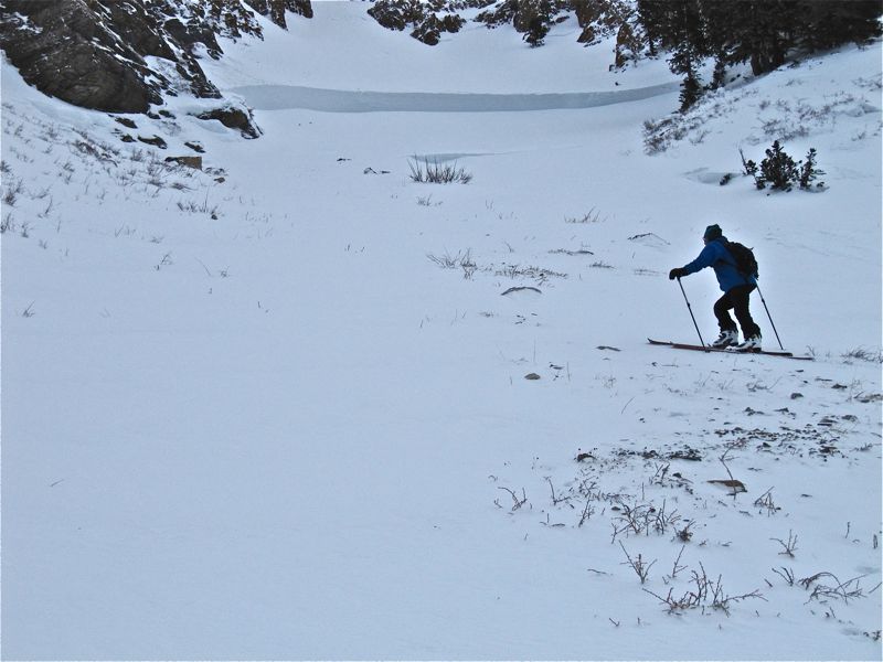
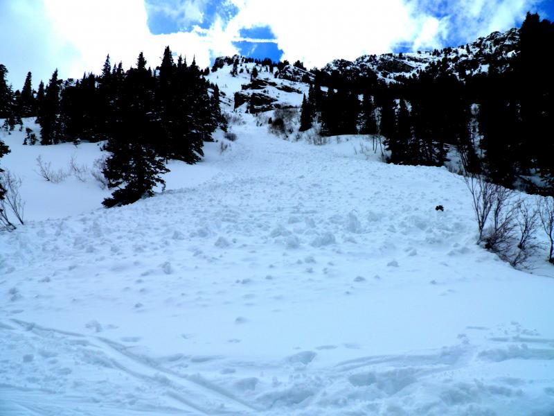
recent activity No significant activity occurred on Sunday however a number of deep slab releases were reported that occurred on Saturday during the strong winds and snow. There were also some late reports of a couple of close calls where skiers/snowboarders were caught and carried over the weekend. (SILVER FORK PHOTOS and PIONEER RIDGE VIDEO) Check out all of the avalanches since Friday HERE.
|
| type | aspect/elevation | characteristics |
|---|

|
|
LIKELIHOOD
 LIKELY
UNLIKELY
SIZE
 LARGE
SMALL
TREND
 INCREASING DANGER
SAME
DECREASING DANGER
|
|
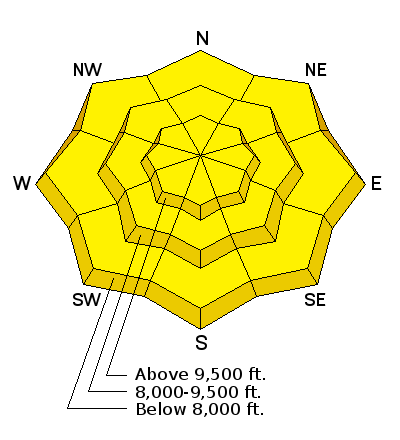
description
Thought you saw the last of the deep slab instability? Think again. As my good friend and UDOT forecaster Bill Nalli put it, "we own those old facets". What he implies is that they are still down deep in our snowpack and we're likely to see them become active with any significant snow event through the rest of the season especially with winds like we saw over the weekend. It is likely that they will become reactive when they go through their first significant warming trend which is still some time to come. On Sunday, my partners and I did avoid a steep northwest facing slope that we were entertaining to ski. We felt it was better to let the new load settle and the deep facets adjust to the new load for a few days. That said, the deep slabs are mostly dormant again at this point and the chances for triggering something that breaks to the ground is fairly unlikely. The most likely locations for problems are any area where the snowpack is shallow which include a lot of west aspects that were loaded by the winds on Saturday. This issue is present above about 9000 feet in elevation. Upper elevation steep, rocky, shallow locations are suspect. |
| type | aspect/elevation | characteristics |
|---|

|

|
LIKELIHOOD
LIKELY
UNLIKELY
SIZE
 LARGE
SMALL
TREND
INCREASING DANGER
SAME
DECREASING DANGER
|
|
description
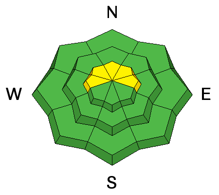
The density inversion that formed early Friday within the new snow is still present but much less reactive now. On Sunday, I did experience one large collapse within this layering that had a wind slab on top of it. However, my partners and I tested and skied on many steep slopes with no issues. For today, watch for any drifting that may occur with the bump in wind speeds. |
| type | aspect/elevation | characteristics |
|---|

|

|
LIKELIHOOD
LIKELY
UNLIKELY
SIZE
LARGE
SMALL
TREND
 INCREASING DANGER
SAME
DECREASING DANGER
|
|
description
During the spring time, you almost always need to consider the potential for heat related avalanche activity especially directly after new snow. For today we should see enough cloud cover to keep this issue at bay. However, temperatures are going to be warmer than Sunday. Consider where you are if the clouds should break. It doesn't take long for the sun to make the new snow unstable. Ask yourself, will I be able to get off or out from underneath a steep slope within a few minutes if the sun comes out? |
 |
weather We'll have mostly cloudy skies with a chance of light snow this morning. West winds will be in the moderate speed range. The sun may try to peek through briefly today. A better system will move through Tuesday giving us some more snow accumulations. We may see another 3 to 6 inches of medium density snow. Wednesday looks like a break then another system is shaping up for Thursday. |
| general announcements Remember your information can save lives. If you see anything we should know about, please participate in the creation of our own community avalanche advisory by submitting snow and avalanche conditions. You can also call us at 801-524-5304 or 800-662-4140, email by clicking HERE, or include #utavy in your tweet or Instagram. If you trigger an avalanche in the backcountry - especially if you are adjacent to a ski area – please call the following teams to alert them to the slide and whether anyone is missing or not. Rescue teams can be exposed to significant hazard when responding to avalanches, and do not want to do so when unneeded. Thanks. Salt Lake and Park City – Alta Central (801-742-2033), Canyons Resort Dispatch (435-615-3322) Snowbasin Resort Dispatch (801-620-1017), Powder Mountain Dispatch (801-745-3772 x 123). Sundance Dispatch (801-223-4150) EMAIL ADVISORY We have switched to a new SLC email advisory system. If you would like to get the daily advisory by email, or if you have been getting the advisory by email since the beginning of the season and wish to continue, you will need to subscribe here. DAWN PATROL Hotline updated daily by 5-530am - 888-999-4019 option 8. Twitter Updates for your mobile phone - DETAILS UDOT canyon closures: LINK TO UDOT Utah Avalanche Center mobile app - Get your advisory on your iPhone along with great navigation and rescue tools.uned. Wasatch Powderbird Guides Blog/Itinerary for the Day. Lost or Found something in the backcountry? - http://nolofo.com/ Discount lift tickets are now available at Backcountry.com - Thanks to Ski Utah and the Utah Resorts. All proceeds go towards paying for Utah Avalanche Center avalanche and mountain weather advisories. To those skinning uphill at resorts: it is your responsibility to know the resort policy on uphill travel. Some allow uphill travel and have guidelines, some don't. Contact the Ski Patrol at each resort for details. IMPORTANT: Before skinning at a resort under new snow conditions, check in with Ski Patrol. Resorts can restrict or cut off access if incompatible with control and grooming operations. Benefit the Utah Avalanche Center when you shop from Backcountry.com or REI: Click this link for Backcountry.com or this link to REI, shop, and they will donate a percent of your purchase price to the UAC. Both offer free shipping (with some conditions) so this costs you nothing! Benefit the Utah Avalanche Center when you buy or sell on ebay - set the Utah Avalanche Center as a favorite non-profit in your ebay account here and click on ebay gives when you buy or sell. You can choose to have your seller fees donated to the UAC, which doesn't cost you a penny. This information does not apply to developed ski areas or highways where avalanche control is normally done. This advisory is from the U.S.D.A. Forest Service, which is solely responsible for its content. This advisory describes general avalanche conditions and local variations always exist. |