| During the month of April, Mark Miller will donate $75 to the charity of your choice (5 to chose from, including the Utah Avalanche Center!) Mark Miller Subaru has raised over $300k in the previous 6 Do Good Feel Good events. More Info here |  |
| During the month of April, Mark Miller will donate $75 to the charity of your choice (5 to chose from, including the Utah Avalanche Center!) Mark Miller Subaru has raised over $300k in the previous 6 Do Good Feel Good events. More Info here | |
| Advisory: Salt Lake Area Mountains | Issued by Evelyn Lees for Friday - January 17, 2014 - 6:51am |
|---|


|
bottom line The avalanche danger of triggering a deep slab avalanche is CONSIDERABLE on steep northwest through easterly facing slopes, above about 9,000’, and MODERATE on the same aspects at the mid elevations. The unpredictable nature of these avalanches makes conservative decision making important. The avalanche danger for wet slides and cornices breaking will rise to MODERATE as the day heats up. Safer shady terrain to recreate on are slopes less steep than about 35 degrees, not directly below or connected to the side of a steeper slope and the sunny slopes before they heat too much.
|
 |
special announcement The Snowbasin Freeride Avalanche Workshop will be held Jan 26-28. This is an avalanche & mountain safety skills workshop for freeride skiers & snowboarders riding & filming big lines. Details and Registration here. Brought to you by the Utah Avalanche Center, Snowbasin, Salomon, Atomic, & Suunto We are switching to a new SLC email advisory system. If you would like to get the daily advisory by email, or if you have been getting the advisory by email since the beginning of the season and wish to continue, you will need to subscribe here. |
 |
current conditions It’s another clear, calm morning, and the mountains have their own little temperature inversion going on. It’s in the teens in the canyon bottoms, with temperatures in the 20s at the most mid and upper elevation stations. The northwesterly winds are quite light this morning, with most high peaks averaging less than 25 mph. Soft snow composed of loose facets and surface hoar exists on sun and wind sheltered slopes. The snow along the high ridgelines is fairly wind hammered, and the widespread crusts on the sunny slopes will soften with daytime heating. |
 |
recent activity Ogden area mountains: a snowmobiler had a 5 foot deep shooting crack on a lower angle section of a Bountiful Peak ridgeline. Salt Lake and Park City mountains – explosive testing released 3 large slides on east and north facing slopes at the resorts. They feel two of these slides, on north facing slopes at 8,800’ and 9,800’, probably could have been triggered by a person. |
| type | aspect/elevation | characteristics |
|---|

|

|
LIKELIHOOD
 LIKELY
UNLIKELY
SIZE
 LARGE
SMALL
TREND
 INCREASING DANGER
SAME
DECREASING DANGER
|
|
description
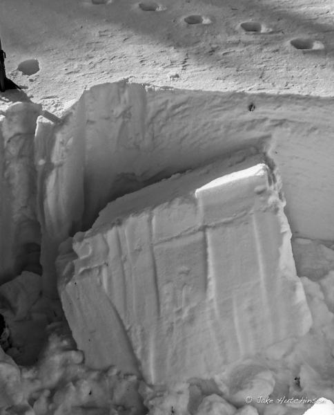
Each day there are fewer places where a person could trigger a deep slides failing on facets, yet the potential size of these slides remains the same. A person would most likely trigger one of these deep slides where the snowpack is thin, such as a rocky spot or a steeper break over. Wind drifted slopes along the high ridge lines are also places with an increased chance of triggering a slide. This means it may not be the first person on a slope to trigger the slide, and that forecasting for an individual slope is difficult. Looking at recent avalanches in the resorts or the backcountry is one of the best ways to visualize the potential danger of avalanches. Jake Hutchinson photo of a snow pit ECT test failure on the "monsters in the basement" facets. (ECTP13 SC / Q1 at 9700' in Silver Fork on a 32 degree east facing slope.)
|
| type | aspect/elevation | characteristics |
|---|

|
|
LIKELIHOOD
LIKELY
UNLIKELY
SIZE
 LARGE
SMALL
TREND
 INCREASING DANGER
SAME
DECREASING DANGER
|
|
description
Daytime heating of the snow will make damp sluffs easy to trigger and also increase the sensitivity of the drooping cornices, which always seem to break back further than expected. If you are recreating on or below steep, sunny slopes, timing is everything. Move to another aspect or lower angles when the snow becomes damp. Warming can also make the old wind slabs more sensitive. |
 |
weather It’s going to be another non-winter day in the mountains – clear, sunny skies with light winds and warm temperatures. 10,000’ temperatures will be in the mid-20s, and the northwesterly winds will average less than 15 mph in most terrain. Even the high peaks should have averages of less than 30 mph. No snow in the forecast for at least a week. |
| general announcements This information does not apply to developed ski areas or highways where avalanche control is normally done. This advisory is from the U.S.D.A. Forest Service, which is solely responsible for its content. This advisory describes general avalanche conditions and local variations always occur. If you trigger an avalanche in the backcountry - especially if you are adjacent to a ski area – please call the following teams to alert them to the slide and whether anyone is missing or not. Rescue teams can be exposed to significant hazard when responding to avalanches, and do not want to do so when unneeded. Thanks. Salt Lake and Park City – Alta Central (801-742-2033), Canyons Resort Dispatch (435-615-3322) Snowbasin Resort Dispatch (801-620-1017), Powder Mountain Dispatch (801-745-3772 x 123). Sundance Dispatch (801-223-4150) EMAIL ADVISORY Get the Salt Lake avalanche advisory emailed to you every morning. CLICK HERE FOR DETAILS DAWN PATROL Hotline updated daily by 5-530am - 888-999-4019 option 8. Twitter Updates for your mobile phone - DETAILS UDOT canyon closures: LINK TO UDOT Utah Avalanche Center mobile app - Get your advisory on your iPhone along with great navigation and rescue tools.uned. Wasatch Powderbird Guides Blog/Itinerary for the Day. They'll be up and running later this winter - Lost or Found something in the backcountry? - http://nolofo.com/ Discount lift tickets are now available at Backcountry.com - Thanks to Ski Utah and the Utah Resorts. All proceeds go towards paying for Utah Avalanche Center avalanche and mountain weather advisories. To those skinning uphill at resorts: it is your responsibility to know the resort policy on uphill travel. Some allow uphill travel and have guidelines, some don't. Contact the Ski Patrol at each resort for details. IMPORTANT: Before skinning at a resort under new snow conditions, check in with Ski Patrol. Resorts can restrict or cut off access if incompatible with control and grooming operations. Benefit the Utah Avalanche Center when you shop from Backcountry.com or REI: Click this link for Backcountry.com or this link to REI, shop, and they will donate a percent of your purchase price to the UAC. Both offer free shipping (with some conditions) so this costs you nothing! Benefit the Utah Avalanche Center when you buy or sell on ebay - set the Utah Avalanche Center as a favorite non-profit in your ebay account here and click on ebay gives when you buy or sell. You can choose to have your seller fees donated to the UAC, which doesn't cost you a penny. Remember your information can save lives. If you see anything we should know about, please participate in the creation of our own community avalanche advisory by submitting snow and avalanche conditions. You can also call us at 801-524-5304 or 800-662-4140, email by clicking HERE, or include #utavy in your tweet or Instagram. Ski Utah mobile snow updates: |