|
The big heat up is here, and this latest assault on the snowpack could bring a widespread round of wet avalanches this weekend into early next week. The heat has some snow to work with – as much as 12 to 18 inches of settled dense snow on the highest, northerly facing slopes, with a few buried crusts to act as sliding surfaces and the winter’s nemesis of lingering faceted layers. While wet sluffs will be the most common heat related avalanche, more dangerous wet slab avalanches are possible the next few days.
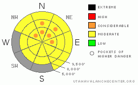
There are numerous red flags to watch for and clues that let you know it’s time to leave the backcountry, or at least stay off of and out from under steep slopes.
· Radically, above freezing temperatures with strong sun.
· Non-freezing nights, especially two or three in a row.
· When the snow surface becomes wet and sloppy.
· Roller balls wheeling down slopes, mostly on mid and upper elevation shady slopes.
· “Bending” of the surface slab as you move across, indicating the slab over a weak layer is barely strong enough to hold your weight.
· Glide cracks – avoid travel below.
· Structure – any layers in the snow pack, from ice crusts to wet facets, add to a weaker snowpack.
The classic spring time routine of very early starts and early finishes will help for Saturday.
Keep in mind that in isolated places, a triggered sluff might gouge into wet snow or trigger a slab avalanche. |