SPECIAL ANNOUNCEMENT |
 |
We will be doing intermittent afternoon avalanche advisories this week, as conditions change. |
|
|
BOTTOM LINE
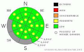
Danger by aspect and elevation on slopes approaching 35° or steeper.
(click HERE for tomorrow's danger rating)
|
Danger Rose Tutorial
|
Looking at the weather for the next few days, the avalanche danger will be generally LOW in the mornings, rising to MODERATE each day with sun and heating for wet loose sluff avalanches at all elevations and on all aspects. As the snow becomes damp each day, wet sluffs large enough to knock you off your feet and take you for a ride will become easy to trigger on steep slopes, and a few spontaneous sluffs are possible. There are a few shallow wind drifts along the highest ridgelines that could be triggered by a person. |
|
|
CURRENT CONDITIONS |

|
It took just a few hours of sun followed by thin clouds “green housing” to destroy the powder. The snow on almost all aspects and all elevations will be crusted this morning, with the exception of a few very high, steep northerly facing slopes, especially those in the shade of gullies or trees. The breakable crusts should warm and the snow soften each day to the consistency of thick mashed potatoes.
Late afternoon and overnight snow showers Saturday dropped a barely discernible 1 to 2 inches of snow in the Salt Lake and Park City mountains, and overnight winds kicked up along the highest ridge lines from the northwest, into the 15 to 20 mph range, with gusts 30 to 50 mph. The winds have now decreased at all but a few stations to averages of less than 15 mph. Temperatures are in the 20s, with a few 30s at the lower elevations and in the Ogden area mountains. |
|
|
RECENT ACTIVITY |

|
Saturday’s avalanche activity consisted of dry sluffs early in the day, quickly transitioning to wet loose sluffs with sun and heating through the clouds. Both natural and easily human triggered sluffs occurred on steep slopes of almost every aspect, with some large enough to take you for a ride. |
|
|
THREAT #1 |

|
| WHERE |
PROBABILITY |
SIZE |
TREND |

|
|
|
|
| |
|
|
Over the next
12 hours.
|
|
|
Each day, heating and any sort of sun – either direct or peeking through thin clouds - will rapidly warm the snow surface, and increase the danger of wet loose sluffs and perhaps a few damp slab avalanches. The sun/thin cloud combination heats the snow on all aspects, including the northerly facing slopes.
The classic spring time routine of very early starts and early finishes will help you to avoid wet avalanche activity. Also switching aspects ahead of the sun can be effective on days without clouds. Plan your backcountry travels to avoid gullies and steep slopes as the snow heats up.
Continue to be suspicious of the wet old snow mid pack and near the ground. This may become more of an issue with the next prolonged warm up late in the week. Keep in mind that in isolated places, with a large trigger such as a newer snow slide, it might be possible for avalanches to gouge into this wet snow.
Note: the grey areas on the danger rose above indicate bare ground. |
|
|
THREAT #2 |

|
| WHERE |
PROBABILITY |
SIZE |
TREND |

|
|
|
|
| |
|
|
Over the next
24 hours.
|
|
|
The avalanche danger is generally LOW each morning, until the snow heats up, when the danger of wet slides will increase to MODERATE. Even with a LOW danger, small avalanche are possible, and general caution is advised. In the wrong terrain, even a small avalanche can be dangerous – it can catch and carry you, pushing you into rocks, off a cliff, into a gully, or take you for a ride in continuously steep terrain. Always use safe travel procedures of one at a time on steep slopes, and evaluate the stability of each slope.
A few small wind drifts may exist along the higher ridgelines from the brisk, overnight, northwesterly winds. |
|
|
MOUNTAIN WEATHER |

|
A moist and somewhat unstable northwest flow over the area today will bring occasional snow showers...mainly in the afternoon, with accumulations of less than 2” expected. Temperatures will warm into the upper 30s at 8,000’ and upper 20s at 10,000’. The winds will remain from the northwest, averaging less than 15 mph, expect for a few high, exposed stations, where gusts in the 30s are still possible. The snow showers will end and skies clear this evening. Weak high pressure will cross the area tonight into Monday, followed by weak systems through mid week, bringing clouds, moderately cool temperatures, and a chance for light snow showers. Then a strong high pressure ridge will move in, with temperatures warming Thursday through the weekend. |
|
|
GENERAL ANNOUNCEMENTS |
GENERAL ANNOUNCEMENTS
If you trigger an avalanche in the backcountry - especially if you are adjacent to a ski area – please call the following teams to alert them to the slide and whether anyone is missing or not. Rescue teams can be exposed to significant hazard when responding to avalanches, and do not want to do so when unneeded. Thanks.
Salt Lake and Park City – Alta Central (801-742-2033)
Ogden – Snowbasin Patrol Dispatch (801-620-1017)
Provo – Sundance Patrol Dispatch (801-223-4150)
Twitter Updates for your mobile phonehttp://utahavalanchecenter.org/twitter)
Daily observations are frequentlypostedby 10 pm each evening.
Subscribe to the daily avalanche advisory e-mail click HERE.
UDOT canyon closuresUDOTat(801) 975-4838
Wasatch Powderbird Guides does daily updates about where they'll be operating on this bloghttp://powderbird.blogspot.com/.
Remember your information can save lives.If you see anything we should know about, please participate in the creation of our own community avalanche advisory by submittingavalanche and snow observations. You can also call us at801-524-5304or800-662-4140, or email by clicking HERE
Donate to your favorite non-profit –The Friends of the Utah Avalanche Center. The UAC depends on contributions from users like you to support our work.
We will update this forecast on an intermittent basis as needed. |
|
|
This information does not apply to developed ski areas or highways where avalanche control is normally done. This advisory is from the U.S.D.A. Forest Service, which is solely responsible for its content. This advisory describes general avalanche conditions and local variations always occur. |
|
This advisory provided by the USDA Forest Service, in partnership with:
The Friends of the Utah Avalanche Center, Utah Division of State Parks and Recreation, Utah Division of Emergency Management, Salt Lake County, Salt Lake Unified Fire Authority and the friends of the La Sal Avalanche Center. See our Sponsors Page for a complete list. |
