SPECIAL ANNOUNCEMENT |
 |
We are updating this advisory only on an intermittent basis as conditions warrant. The next advisory will be by 7:30 am Sunday morning, April 14th. |
|
|
BOTTOM LINE
Danger by aspect and elevation on slopes approaching 35° or steeper.
(click HERE for tomorrow's danger rating)
|
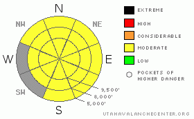
Danger Rose Tutorial
|
The avalanche danger is MODERATE on steep slopes for triggering shallow, new snow sluffs, soft slabs and a few wind drifts. The wind drifts will become deeper and more wide spread as the winds shift to the north and increase this afternoon. The danger of wet snow avalanches will increase to MODERATE as the day warms or any time the clouds thin or the sun comes out. It may be April, but continue your safe winter travel protocol – one at a time on steep slopes, get out of the way at the bottom, and have an escape plan. |
|
|
CURRENT CONDITIONS |

|
It will be worth putting away your summer toys for a day, and getting back out the sleds, skis and boards – a cold powder storm has returned winter to the mountains. While some intermittent sun and heating did thicken and crust the mid elevation and sunny slopes, creamy, cold powder conditions remain on upper elevation northerly facing slopes.
This morning, light snow is falling throughout most of the northern mountains on a southeasterly flow. The Park City ridge line has received 2 to 5” of new snow, with most other locations an inch or two. This is capping off the late week storm totals of 1 to 2 feet in the Cottonwoods and 8 to 14” in the Ogden, Park City and Provo area mountains. The southeasterly winds are generally less than 10 mph this morning, and temperatures are in the 20s, with a few teens along the highest ridges. |
|
|
RECENT ACTIVITY |

|
Most of Friday’s avalanche activity was small, predictable soft slabs and sluffs on steep slopes and a few shallow sensitive wind drifts along the highest ridge lines. A larger soft slab was reported from the steep, east facing side of Square Top on the Park City ridge line - 8 inches deep by 80' wide, running far enough to amassing a decent debris pile. The resorts reported a mix of small to “good sized” loose snow sluffs, with a few slightly larger explosive triggered soft slabs on upper elevation north and northeast facing slopes. |
|
|
THREAT #1 |

|
| WHERE |
PROBABILITY |
SIZE |
TREND |

|
|
|
|
| |
|
|
Over the next
12 hours.
|
|
|
Almost all of today’s avalanche issues will involve the new snow only, but these slides will be big enough to catch and carry a person. Spring snow settles and strengthens rapidly, but it will be possible to trigger both soft slabs and sluffs on steep slopes, especially the upper elevation, northerly facing slopes. Careful slope cuts, starting on smaller test slopes and breakovers will give you a feel for the sensitivity of the new snow where you are.
Small wind drifts exist along the higher ridge lines. Over night, a few ridge lines had moderate southeasterly winds, later today the winds will shift more to the north. With all these erratic wind directions, watch for drifts on all aspects. Winds speeds are forecast to increase by this afternoon, so be alert for drifting snow where you are, with drifts increasing in both depth and sensitivity.
Note: the grey areas on the danger rose above indicate bare ground. |
|
|
THREAT #2 |

|
| WHERE |
PROBABILITY |
SIZE |
TREND |
|
|
|
|
| |
|
|
Over the next
12 hours.
|
|
|
Daytime heating and any sort of sun – either direct or peeking through thin clouds - will rapidly heat the new snow, making it very sensitive. The sun/thin cloud combination can heat the snow on the northerly facing slopes, too. Early starts and finishes, remaining on the cooler, northerly facing slopes, and having a plan for exiting the backcountry avoiding steep, heating slopes all will minimize the wet avalanche danger.
It doesn’t take much detective work to find the old wet snow beneath the thin frozen crust. This wet snow seems to lack any motivation to move. But in isolated places, with a large trigger such as a new snow slide or a several people on a steep slope at the same time, it might be possible for avalanches to gouge into this wet snow. And while deep in the pack, and currently quiet, digging to the ground also find wet facets still lurking. Check out this observation HERE. |
|
|
MOUNTAIN WEATHER |

|
The cold low pressure system centered over Las Vegas this morning will keep northern Utah under a southeasterly flow for much of today. Periods of light snow should give the mountains an additional 2 to 5” of snow today. Temperatures will warm into the low 30s at 8,000’ and remain in the 20s at 10,000. The light southeasterly winds will gradually shift to the north and increase this afternoon, with the highest peaks averaging 10 to 20 mph, with gusts to 30. Temperatures will cool into the teens and 20s again tonight. Lingering snow showers tonight and Sunday will bring a few additional inches of snow. |
|
|
GENERAL ANNOUNCEMENTS |
GENERAL ANNOUNCEMENTS
If you trigger an avalanche in the backcountry - especially if you are adjacent to a ski area – please call the following teams to alert them to the slide and whether anyone is missing or not. Rescue teams can be exposed to significant hazard when responding to avalanches, and do not want to do so when unneeded. Thanks.
Salt Lake and Park City – Alta Central (801-742-2033)
Ogden – Snowbasin Patrol Dispatch (801-620-1017)
Provo – Sundance Patrol Dispatch (801-223-4150)
Twitter Updates for your mobile phonehttp://utahavalanchecenter.org/twitter)
Daily observations are frequentlypostedby 10 pm each evening.
Subscribe to the daily avalanche advisory e-mail click HERE.
UDOT canyon closuresUDOTat(801) 975-4838
Wasatch Powderbird Guides does daily updates about where they'll be operating on this bloghttp://powderbird.blogspot.com/.
Remember your information can save lives.If you see anything we should know about, please participate in the creation of our own community avalanche advisory by submittingavalanche and snow observations. You can also call us at801-524-5304or800-662-4140, or email by clicking HERE
Donate to your favorite non-profit –The Friends of the Utah Avalanche Center. The UAC depends on contributions from users like you to support our work.
We will update this forecast on an intermittent basis as needed. |
|
|
This information does not apply to developed ski areas or highways where avalanche control is normally done. This advisory is from the U.S.D.A. Forest Service, which is solely responsible for its content. This advisory describes general avalanche conditions and local variations always occur. |
|
This advisory provided by the USDA Forest Service, in partnership with:
The Friends of the Utah Avalanche Center, Utah Division of State Parks and Recreation, Utah Division of Emergency Management, Salt Lake County, Salt Lake Unified Fire Authority and the friends of the La Sal Avalanche Center. See our Sponsors Page for a complete list. |
