SPECIAL ANNOUNCEMENT |
 |
Check out the Online store above for ski passes - there are still weeks of great spring skiing left, and perhaps a few powder storms still coming. All proceeds go to our partner the Friends of the Utah Avalanche Center. |
|
|
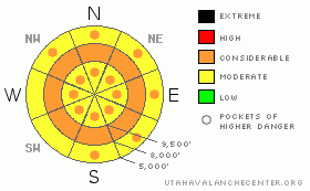
BOTTOM LINE
Danger by aspect and elevation on slopes approaching 35° or steeper.
(click HERE for tomorrow's danger rating)
|
Danger Rose Tutorial
|
The avalanche danger is MODERATE early this morning, rapidly increasing to pockets of CONSIDERABLE on almost all elevations and aspects with daytime heating, with the avalanche danger at mid elevations rising to a CONSIDERABLE. Both natural and human triggered wet slab and wet sluff avalanches are possible. Early starts and finishes are critical - get off of and out from under steep slopes before the snow become damp and sloppy or the frozen crusts become punchy or breakable. |
|
|
CURRENT CONDITIONS |

|
Under partly cloudy skies, the southerly winds are at it once again, and having increased to near 20 mph, with gusts to 40. Wind speeds across the high terrain in the Ogden area mountains are stronger, averaging 30 to 40 mph, with gusts to 50. Temperatures have notched it up, generally 2-6 degrees warmer than yesterday morning. Upper 30s to low 40s are common readings at 9,000’ and below, with temperatures just below freezing above about 10,000’. |
|
|
RECENT ACTIVITY |

|
Yesterday, natural wet loose sluffs were reported from the SLC and Ogden area mountains, on northerly and northeasterly facing slopes, around 7,500 to 8,000’. Full pack collapses were reported from shallow, isothermal snowpack areas on Park City side. |
|
|
THREAT #1 |

|
| WHERE |
PROBABILITY |
SIZE |
TREND |

|
|
|
|
| |
|
|
Over the next
12 hours.
|
|
|
The main avalanche concern today is wet snow slides – both sluffs and slabs. Wet sluffs will be easy to trigger on any steep slope as soon as the surface snow heats and becomes damp. Wet slab avalanches are the more dangerous cousin of wet sluffs. This week’s prolonged period of nonfreezing temperatures at the mid and lower elevations has allowed the snow to become wet all the way to the ground, and increased the chance for erratic wet slab avalanches, especially on slopes with a shallower snowpack.
Again today, it’s a stability dance between wind, cloud cover and temperature – travelers need to constantly evaluate the balance between the three, and realize snow conditions can change within minutes if the sun busts out or the winds stop blowing where you are. The snow will heat and rapidly become unstable.
· Early starts, early finishes, by around noon or earlier - as soon the snow surface starts to heat and become wet or the crusts soften.
· Be ready to change aspect – move on to cooler slopes with less direct sun.
· Be aware of slopes heating above you, especially on exits.
· Avoid travel in and above terrain traps like gullies
· Cornices are very weak, ready to break back further than expected.
· Avoid travel below glide cracks, which could release as slab avalanches. |
|
|
MOUNTAIN WEATHER |

|
The monotonous warm, southwesterly flow will continue today through midday Saturday before we get relief from a cold Pacific storm system that will arrive on Saturday night. Skies will be partly cloudy today south of about I-80, with mostly cloudy skies to the north. Temperatures will warm to near 50 at 8,000’ and into the mid 30s at 10,000’. The southerly winds will slowly increase throughout the day, and then become much stronger tonight into Saturday as the cold front approaches. The cold front is forecast to reach the northern mountains Saturday night with one good burst of snow, followed by snow showers Sunday into Monday, with 1 to 2 foot storm totals by Tuesday. |
|
|
GENERAL ANNOUNCEMENTS |
If you trigger an avalanche in the backcountry - especially if you are adjacent to a ski area – please call the following teams to alert them to the slide and whether anyone is missing or not. Rescue teams can be exposed to significant hazard when responding to avalanches, and do not want to do so when unneeded. Thanks.
Salt Lake and Park City – Alta Central (801-742-2033)
Ogden – Snowbasin Patrol Dispatch (801-620-1017)
Provo – Sundance Patrol Dispatch (801-223-4150)
Dawn Patrol Forecast Hotline, updated by 05:30: 888-999-4019 option 8.
Twitter Updates for your mobile phone http://utahavalanchecenter.org/twitter)
Daily observations are frequentlypostedby 10 pm each evening.
Subscribe to the daily avalanche advisory e-mail clickHERE.
UDOT canyon closuresUDOTat (801) 975-4838
Wasatch Powderbird Guides does daily updates about where they'll be operating on this blog http://powderbird.blogspot.com/.
Remember your information can save lives.If you see anything we should know about, please participate in the creation of our own community avalanche advisory by submittingavalanche and snow observations. You can also call us at 801-524-5304 or 800-662-4140, or email by clickingHERE
Donate to your favorite non-profit –The Friends of the Utah Avalanche Center. The UAC depends on contributions from users like you to support our work.
We will update this forecast tomorrow morning. Thanks for calling. |
|
|
This information does not apply to developed ski areas or highways where avalanche control is normally done. This advisory is from the U.S.D.A. Forest Service, which is solely responsible for its content. This advisory describes general avalanche conditions and local variations always occur. |
|
This advisory provided by the USDA Forest Service, in partnership with:
The Friends of the Utah Avalanche Center, Utah Division of State Parks and Recreation, Utah Division of Emergency Management, Salt Lake County, Salt Lake Unified Fire Authority and the friends of the La Sal Avalanche Center. See our Sponsors Page for a complete list. |
