SPECIAL ANNOUNCEMENT |
 |
UDOT will be conducting artillery firing in LCC midday today, and there is a Backcountry Closure in effect for all terrain north of the road in Little Cottonwood Canyon from closure gateB below Lisa Falls through gateD below Superior through about noon today. |
|
|
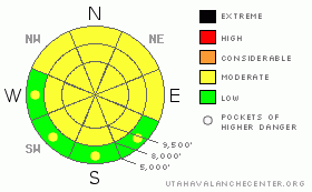
BOTTOM LINE
Danger by aspect and elevation on slopes approaching 35° or steeper.
(click HERE for tomorrow's danger rating)
|
Danger Rose Tutorial
|
Early starts and finishes are the way to avoid wet slab and wet sluff avalanches. The early morning LOW danger for wet slides will rise to MODERATE as the snow heats up. Continuously monitor the snowpack heating – conditions can change fast, in less than an hour- if the winds die, the clouds thin and the sun comes out or you enter wind sheltered terrain. Wet slides have dense, cement like debris, hard to dig through.
There continues to be a MODERATE danger on slopes facing west through north through southeast for triggering a slab avalanche 1 to 4 feet deep, breaking on a buried faceted weak layer. Most wide spread above about 8,000’. |
|
|
CURRENT CONDITIONS |

|
Under partly cloudy skies and strong southerly winds, it is another warm morning. Temperatures are a few degrees below freezing along most of the higher ridges, but have remained in the mid 30s to low 40s in the 7 to 9,000 foot terrain. The southerly winds are averaging 20 to 30, with gusts in the 40s, with the higher peaks averaging to 45 mph, with gusts in the 70s. Below - 9,600'.

Above - 8900 feet
With the cooling winds, there should be a good surface refreeze on most mid and upper elevation slopes. However, the icy, but supportable crusts will be slow to soften today. There is just a smattering of soft snow left on upper elevation northerly facing slopes. |
|
|
RECENT ACTIVITY |

|
The only reported avalanche was a natural shallow wet slide in the Canyons sidecountry yesterday afternoon, about 10” deep by 35’ wide, entraining snow as it ran down slope. |
|
|
THREAT #1 |

|
| WHERE |
PROBABILITY |
SIZE |
TREND |
|
|
|
|
| |
|
|
Over the next
11 hours.
|
|
|
Wet avalanches are a completely different animal. They account for about 9% of US avalanche fatalities, and of those fatalities only 35% were human triggered -- the other 47% people died from naturally occurring slides. (Larry Heyward National Avalanche School talk, 2011)
We will be struggling all week with wet slides, and backcountry travelers need to constantly evaluate the balance between temperatures, wind and cloud cover. Today, the strong winds should keep the snow cool for most of the day, especially at the upper elevations. The issue today will be any very wind sheltered slopes, especially at the mid to lower elevations, any periods of strong sun, or if the winds significantly decrease late in the day.
To avoid most of the wet avalanche danger:
· Early starts, early finishes, by around noon or when ever the snow surface starts to heat and become wet.
· Be aware of slopes heating above you, especially on exits.
· Cornices are slumping, and ready to break, often back further than expected.
· Avoid travel below the opening glide cracks, which could release as slab avalanches. |
|
|
THREAT #2 |

|
| WHERE |
PROBABILITY |
SIZE |
TREND |
|
|
|
|
| |
|
|
Over the next
11 hours.
|
|
|
With poor snowpack structure - buried layers of faceted snow overlain by slabs of dense snow - all steep slopes are a suspect. The most likely place to trigger a dry slab avalanche is on a slope with a shallow snowpack, especially in rocky areas. In a few isolated places, a slide could still be triggered remotely. |
|
|
MOUNTAIN WEATHER |

|
Storms systems will continue to track to the north, keeping Utah under a warm, southwesterly flow. Skies will be partly cloudy today, with some breaks allowing for sun. The southerly winds will be strongest this morning, with average speeds in the 20 to 30 mph range, with gusts to 50, and the highest peaks gusting into the 70s. Speeds will gradually decrease into the afternoon, though the high ridges will still gust into 50s. Temperatures will warm into the mid 40s at 8,000’ and to around 30 at 10,000’. There will be a break in the winds on Wednesday, before they increase once again on Thursday as another storm passes to the north. |
|
|
This information does not apply to developed ski areas or highways where avalanche control is normally done. This advisory is from the U.S.D.A. Forest Service, which is solely responsible for its content. This advisory describes general avalanche conditions and local variations always occur. |
|
This advisory provided by the USDA Forest Service, in partnership with:
The Friends of the Utah Avalanche Center, Utah Division of State Parks and Recreation, Utah Division of Emergency Management, Salt Lake County, Salt Lake Unified Fire Authority and the friends of the La Sal Avalanche Center. See our Sponsors Page for a complete list. |
