BOTTOM LINE
Danger by aspect and elevation on slopes approaching 35° or steeper.
(click HERE for tomorrow's danger rating)
|
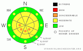
Danger Rose Tutorial
|
On mid and upper elevation slopes facing west through southeast, there is a MODERATE avalanche danger of triggering a slab avalanche on one of the persistent buried weak layers, most likely in shallow snowpack areas. If you are getting into steep terrain, evaluate the snow carefully and follow safe travel procedures of one at a time.
Also, the avalanche danger for wet loose sluffs and even a slab will increase to MODERATE with pockets of CONSIDERABLE with day time heating. Get off of and out from under steep slopes as the snow heats up and becomes damp.
|
|
|
CURRENT CONDITIONS |

|
Strong high pressure over Utah has brought clear skies, with temperatures this morning in the upper 20s to near freezing at 9,000’ and above. The winds have decreased, and are less than 15 mph, even across the highest peaks. Variable is the operative word to describe snow conditions – wind crust, sun crust, damp snow as the day heats up, icy along the high ridges… but there is a wedge of dry, settled powder on sheltered, northerly, mid to upper elevation slopes. If you’re using skins, wax and a scraper will be useful.
|
|
|
RECENT ACTIVITY |

|
There were no new avalanches triggered yesterday, though clear skies made sightseeing interesting, and there are some great photos from the last avalanche cycle HERE. There was also a report of what may be a newer slide off the backside of Clayton Peak.
Mark White Photo: Debris from Kessler avalanche, probably 3/4/2012.

|
|
|
THREAT #1 |

|
| WHERE |
PROBABILITY |
SIZE |
TREND |
|
|
|
|
| |
|
|
Over the next
10 hours.
|
|
|
There seems to be a bit of a truce with the variety of persistent weak layers in the snowpack at the moment – they seem tired out from last week’s storms and heating. However, the steep slopes are still suspect, due to the structural weaknesses of a strong slab sitting on a persistent weak layer. Today’s warm temperatures could have a creeping snowpack tugging once again on those weak layers, making them easier to trigger. The most likely place to trigger a deeper slab avalanche continues to be shallower snowpack areas, including slopes that have slid earlier this year and reloaded.
|
|
|
THREAT #2 |

|
| WHERE |
PROBABILITY |
SIZE |
TREND |
|
|
|
|
| |
|
|
Over the next
11 hours.
|
|
|
While temperatures won’t reach the 50s of last Sunday and Monday, the combination of 30s and 40s with no wind will heat the snow surface enough to produce another round of wet avalanches – mostly human triggered wet sluffs if you’re on a steep slope too late in the day. But don’t rule out a few natural wet sluff releases, including lower elevation, northerly facing slopes where the cold snow is becoming damp for the first time, and perhaps a wet slab avalanche. Avoid wet snow avalanche problems with early starts and finishes, by switching aspect as the snow heats up and not traveling beneath steep, hot sunlit slopes. Cornices will also become more sensitive with the heating.
|
|
|
MOUNTAIN WEATHER |

|
Like it or not, spring seems to have arrived for the next few days, with clear skies and warm temperatures through the weekend. Today will be a sizzler, with 10,000’ temperatures climbing into the low to mid 30s and barely a breath of wind off the ridgelines. At 8,000’, highs will be in the upper 40’s. The northeasterly winds will average less than 15 mph even across the highest ridgelines. The unseasonably warm temperatures will continue through the weekend, with the next chance for any light snow around Monday or Tuesday.
|
|
|
GENERAL ANNOUNCEMENTS |
If you trigger an avalanche in the backcountry - especially if you are adjacent to a ski area – please call the following teams to alert them to the slide and whether anyone is missing or not. Rescue teams can be exposed to significant hazard when responding to avalanches, and do not want to do so when unneeded. Thanks.
Salt Lake and Park City – Alta Central (801-742-2033)
Ogden – Snowbasin Patrol Dispatch (801-620-1017)
Provo – Sundance Patrol Dispatch (801-223-4150)
Dawn Patrol Forecast Hotline, updated by 05:30: 888-999-4019 option 8.
Twitter Updates for your mobile phone http://utahavalanchecenter.org/twitter)
Daily observations are frequently posted by 10 pm each evening.
Subscribe to the daily avalanche advisory e-mail click HERE.
UDOT canyon closures UDOT at (801) 975-4838
Wasatch Powderbird Guides does daily updates about where they'll be operating on this blog http://powderbird.blogspot.com/ .
Remember your information can save lives. If you see anything we should know about, please participate in the creation of our own community avalanche advisory by submitting avalanche and snow observations. You can also call us at 801-524-5304 or 800-662-4140, or email by clicking HERE
Donate to your favorite non-profit –The Friends of the Utah Avalanche Center. The UAC depends on contributions from users like you to support our work.
We will update this forecast tomorrow morning. Thanks for calling. |
|
|
This information does not apply to developed ski areas or highways where avalanche control is normally done. This advisory is from the U.S.D.A. Forest Service, which is solely responsible for its content. This advisory describes general avalanche conditions and local variations always occur. |
|
This advisory provided by the USDA Forest Service, in partnership with:
The Friends of the Utah Avalanche Center, Utah Division of State Parks and Recreation, Utah Division of Emergency Management, Salt Lake County, Salt Lake Unified Fire Authority and the friends of the La Sal Avalanche Center. See our Sponsors Page for a complete list. |
