BOTTOM LINE
Danger by aspect and elevation on slopes approaching 35° or steeper.
(click HERE for tomorrow's danger rating)
|
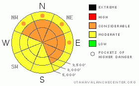
Danger Rose Tutorial
|
There are three avalanche issues today:
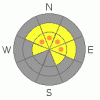
· First, on mid and upper elevation slopes facing northwest through southeast, there is a CONSIDERABLE avalanche danger of triggering a slab avalanche 1 to 4 feet deep, breaking on a persistent buried weak layer.
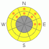
· Second, the strong southerly winds have created Pockets of CONSIDERABLE avalanche danger for triggering a fresh wind drift, which will be most widespread on upper elevation northwest through northeasterly facing slopes.
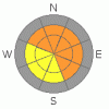
· Third, there are Pockets of CONSIDERABLE avalanche danger for triggering a wet slab avalanche or damp sluff on low and mid elevation slopes where the snow is wet and soggy. |
|
|
CURRENT CONDITIONS |

|
Under overcast skies, the southerly winds are cranking, averaging 20 to 30 mph, with gusts in 40s at the mid elevations. Across the high ridgelines, speeds are 30 to 40 mph, with “knock you off your feet” gusts in the 50s and 60s. Temperatures cooled into the upper 20s at 10,000’ and above, but remained above freezing at the mid and low elevations, in the mid 30s to low 40s. Remnants of powder exist on very wind sheltered mid and upper elevation northerly facing slopes. Elsewhere, it will be crusted or damp. |
|
|
RECENT ACTIVITY |

|
 There were 4 heat related spontaneous avalanches reported yesterday. 3 were along the Park City ridgeline, all on east northeasterly facing slopes, at around 9,500’. They were 1 to 2 feet deep and up to 150’ wide, 2 on Pinecone ridge and one in the Cinder Chutes. The 4th slide was on a southeasterly facing slope, in Cardiff Fork near Kessler, about 4 feet deep by 100’ wide. Pinecone Ridge slides, photo above taken by Patroller Jamie McMillan. There were 4 heat related spontaneous avalanches reported yesterday. 3 were along the Park City ridgeline, all on east northeasterly facing slopes, at around 9,500’. They were 1 to 2 feet deep and up to 150’ wide, 2 on Pinecone ridge and one in the Cinder Chutes. The 4th slide was on a southeasterly facing slope, in Cardiff Fork near Kessler, about 4 feet deep by 100’ wide. Pinecone Ridge slides, photo above taken by Patroller Jamie McMillan.
|
|
|
THREAT #1 |
|
|
|
THREAT #2 |

|
| WHERE |
PROBABILITY |
SIZE |
TREND |
|
|
|
|
| |
|
|
Over the next
24 hours.
|
|
|
Even though much of the snow surface is damp or crusted, the strong southerly winds will find snow to drift, forming new wind slabs. These wind slabs or drifts will be most sensitive on where they land on dry snow – mostly slopes facing northwest through northeast, at the mid and upper elevations. With high wind speeds, be observant – drifts will be in scattered and erratic locations. |
|
|
THREAT #3 |

|
| WHERE |
PROBABILITY |
SIZE |
TREND |
|
|
|
|
| |
|
|
Over the next
12 hours.
|
|
|
It will be a tug of war again today between the wind and warm temperatures, with the cooling wind generally winning. However, much of the mid and lower elevation terrain has had above freezing temperatures for the past 48 hours, and while the winds maybe cooling the snow surface, the snowpack is wet beneath. Watch out for triggering wet sluffs and even wet slabs steep terrain, and avoid terrain traps such as gullies and creek beds. Thick slabs of snow and ice are still sliding off roofs into deep, deadly piles. Also, many of the gullies above the ice climbing routes in the range are avalanche paths, and suspect with the continued warm temperatures. |
|
|
MOUNTAIN WEATHER |

|
Cloudy skies and strong winds will be with us for the day ahead of the cold front which should arrive late afternoon or early evening. Once again, it’s a splitter, with most of the energy and moisture going south. Today, temperatures will warm into the low to mid 40’s at 8,000’ and near 30 at 10,000’. The southwesterly winds will remain strong, with 20 to 30 mph averages, and gusts in the 40s across much of the terrain, with the high ridges averaging 30 to 40 mph, and gusts in the 60s. Light snow tonight with the front will dust the northern Utah mountains with 2 to 5” of snow. Winds will shift to the east, and then northeast and gradually decrease. Then it’s a dry warming trend through the weekend. |
|
|
GENERAL ANNOUNCEMENTS |
If you trigger an avalanche in the backcountry - especially if you are adjacent to a ski area – please call the following teams to alert them to the slide and whether anyone is missing or not. Rescue teams can be exposed to significant hazard when responding to avalanches, and do not want to do so when unneeded. Thanks.
Salt Lake and Park City – Alta Central (801-742-2033)
Ogden – Snowbasin Patrol Dispatch (801-620-1017)
Provo – Sundance Patrol Dispatch (801-223-4150)
Dawn Patrol Forecast Hotline, updated by 05:30: 888-999-4019 option 8.
Twitter Updates for your mobile phone http://utahavalanchecenter.org/twitter)
Daily observations are frequently posted by 10 pm each evening.
Subscribe to the daily avalanche advisory e-mail click HERE.
UDOT canyon closures UDOT at (801) 975-4838
Wasatch Powderbird Guides does daily updates about where they'll be operating on this blog http://powderbird.blogspot.com/ .
You have the opportunity to participate in the creation of our own community avalanche advisory by submitting avalanche and snow observations. You can also call us at 801-524-5304 or 800-662-4140, or email by clicking HERE
Donate to your favorite non-profit –The Friends of the Utah Avalanche Center. The UAC depends on contributions from users like you to support our work.
We will update this forecast tomorrow morning. Thanks for calling. |
|
|
This information does not apply to developed ski areas or highways where avalanche control is normally done. This advisory is from the U.S.D.A. Forest Service, which is solely responsible for its content. This advisory describes general avalanche conditions and local variations always occur. |
|
This advisory provided by the USDA Forest Service, in partnership with:
The Friends of the Utah Avalanche Center, Utah Division of State Parks and Recreation, Utah Division of Emergency Management, Salt Lake County, Salt Lake Unified Fire Authority and the friends of the La Sal Avalanche Center. See our Sponsors Page for a complete list. |

 There are multiple persistent weak layers in the snowpack at varying depths and on all aspects ‘round the compass. The upper weak layers, many associated with a thin ice crust, have been most active on northeast, east and southeasterly facing slopes the past few days. However, all steep mid and upper elevation slopes remain suspect due to the structural weaknesses of a strong slab sitting on a persistent weak layer. In very shallow snowpack areas, avalanches could still break near the ground.