Salt Lake Avalanche Advisory

Forecaster: Drew Hardesty

SPECIAL ANNOUNCEMENT

UDOT will do avalanche control work in Little Cottonwood Canyon. It should reopen by about 730am. Be sure to monitor the website and text messages.


BOTTOM LINE

Danger by aspect and elevation on slopes approaching 35° or steeper.
(click HERE for tomorrow's danger rating)


Danger Rose Tutorial

The danger is CONSIDERABLE. Dangerous conditions exist in the backcountry. Human triggered avalanches 2-4’ deep and 200’ wide are likely and not necessarily confined to aspect or elevation. Your only trump card is to stay on slopes less than 30 degrees with nothing steeper above. Give the yawning cornices a wide berth. Any avalanches may step down into the early season snow to near the ground.


CURRENT CONDITIONS

Let me get this out of the way – The skiing and riding conditions bordered on the sublime yesterday. Out of the wind, you’ll find the same today. Skies are overcast with many areas reporting a trace to 2 overnight. Storm totals since Monday night are roughly 40-45” in Big and Little Cottonwood, 20-30” in the Park City and Ogden area mountains, and 35” in Provo. It’s been quite the week. Winds are strong along the high ridgelines from the west-northwest, blowing 45-50mph with gusts to 60. Lower anemometers still show healthy gusts as well. Temps are in the single digits to low teens.

Double corniced ridges are becoming commonplace. (It's not the French? ridge of Mt Hunter, but you get the idea)


RECENT ACTIVITY

A fairly wild day in the backcountry yesterday. You can find all these reports under Current Conditions – Check the Provo and Ogden advisories for avalanche reports there -

Naturals reported from the early AM

· Main Days wrapped into Banana Days maybe 3-4’ deep and 1000’ wide ENE at 10400’

· Beartrap Southeast facing at 9200’ 2’ deep

· Doug’s Drop and adjacent lower slope in Silver Fork 9600’-9400’ East/Southeast

· Wolverine Peak 10,600’ north facing dimensions unknown

· Multiple cycles off the Cottonwood ridgeline above LCC south facing

Human triggered Slides reported from the Central Wasatch

· Holbrook Creek above Bountiful 8400’ North Snowmobile triggered and almost full burial. Dimensions 2-3’ deep and 50’ wide.

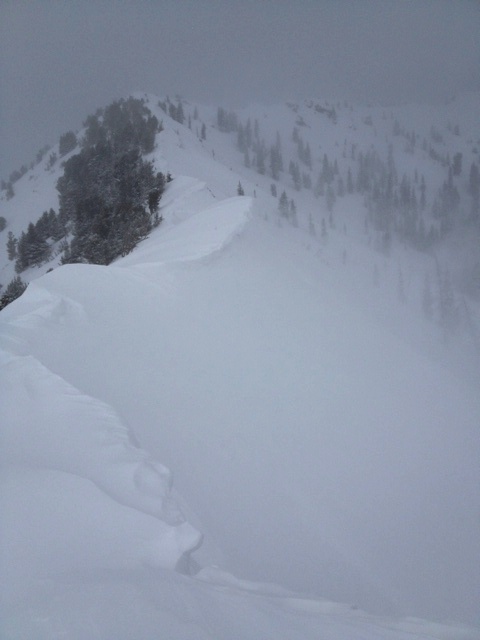
· Lambs Canyon 8900’ NE remotely triggered from ridgeline 3’ deep and approx 400’ wide (Stireman pic below)

· Reynolds (above BCC) South Face SE at 9000’ 18” deep and 200’ wide

· Silver Fork (along ridge between West Bowl and Doug’s Drop/Meadow Chutes 2-3’ deep and 200’ wide east southeast at 9900’

· Iron Mountain northeast facing at approx 8700’, dimensions unknown

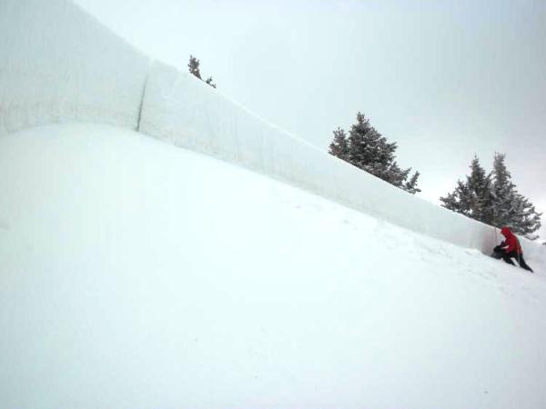
· Porter Fork of Mill Creek – intentional cornice drop pulled out 12”x 40’ wide pocket at 9600’


THREAT #1

WHERE PROBABILITY SIZE TREND
      Over the next 24 hours.

The persistent slabs are not reacting well at all to 30-50” of snow and alternating strong southerly and then northwesterly winds from the last couple of weeks. Human triggered slides – even remotely triggered slides – remain likely on all aspects. They’ve been most common on northeast to southeast facing slopes above 9000’, yet collapsing persists on due south as well. These we can anticipate to some degree. Still – the outliers on due south and southwest (last Sat/Sun) and low elevation – Summit Park < 8000’ northerly on Tuesday should inspire caution in all terrain. While the bulk of the natural avalanching is over, dangerous conditions remain.

I know you’re hungry. So am I. But the only thing on the plate is Temptation. It’ll be up to you, gentle reader, to maintain discipline above all else, look down upon the sheet of untracked white on the 38 degree slope…and walk on by.


THREAT #2

WHERE PROBABILITY SIZE TREND
      Over the next 24 hours.

The moderate to strong northwesterly winds will easily have its way with this last storm’s 6-8% smoke. When wind slabs become 2-3’ deep, you may want to trade your kingdom for a hand charge, but they’re too big and unmanageable on your own. Avoid the upper elevation drifts – primarily easterly facing – though anticipate some cross-loading to some extent as well. Dramatic cornice build-up will also result in some natural calving as well and react well to travel from above.


MOUNTAIN WEATHER

Moisture riding in on a strong northwest flow will keep mostly cloudy to overcast skies above the range. Temps will be rise from the single digits to mid-teens at 10,000’. High pressure builds in overnight and we’ll have clear skies and spiking temps to near freezing by tomorrow. A splitting system arrives Tuesday night.


GENERAL ANNOUNCEMENTS

If you trigger an avalanche in the backcountry - especially if you are adjacent to a ski area – please call the following teams to alert them to the slide and whether anyone is missing or not. Rescue teams can be exposed to significant hazard when responding to avalanches, and do not want to do so when unneeded. Thanks.

Salt Lake and Park City – Alta Central (801-742-2033)

Ogden – Snowbasin Patrol Dispatch (801-620-1017)

Provo – Sundance Patrol Dispatch (801-223-4150)

Dawn Patrol Forecast Hotline, updated by 05:30: 888-999-4019 option 8.

Twitter Updates for your mobile phone http://utahavalanchecenter.org/twitter)

Daily observations are frequently posted by 10 pm each evening.

Subscribe to the daily avalanche advisory e-mail click HERE.

UDOT canyon closures UDOT at (801) 975-4838

Wasatch Powderbird Guides does daily updates about where they'll be operating on this blog http://powderbird.blogspot.com/ .

You have the opportunity to participate in the creation of our own community avalanche advisory by submitting avalanche and snow observations. You can also call us at 801-524-5304 or 800-662-4140, or email by clicking HERE

Donate to your favorite non-profit –The Friends of the Utah Avalanche Center. The UAC depends on contributions from users like you to support our work.

We will update this forecast tomorrow morning. Thanks for calling.


This information does not apply to developed ski areas or highways where avalanche control is normally done.  This advisory is from the U.S.D.A. Forest Service, which is solely responsible for its content. This advisory describes general avalanche conditions and local variations always occur.


This advisory provided by the USDA Forest Service, in partnership with:

The Friends of the Utah Avalanche Center, Utah Division of State Parks and Recreation, Utah Division of Emergency Management, Salt Lake County, Salt Lake Unified Fire Authority and the friends of the La Sal Avalanche Center. See our Sponsors Page for a complete list.