AVALANCHE WARNING »
Dangerous avalanche conditions are occuring or are imminent.
Backcountry travel in avalanche terrain is not recommended.
|
 |
Notice: Strong winds will keep the avalanche danger HIGH today in the mountains of northern and central Utah. Drifting snow will continue to overload weak layers in the snowpack. Large dangerous avalanches can be triggered on steep slopes and natural avalanches are possible. Backcountry travelers should avoid all travel on and below slopes steeper than about 30 degrees. |
|
|
BOTTOM LINE
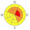
Danger by aspect and elevation on slopes approaching 35° or steeper.
(click HERE for tomorrow's danger rating)
|

Danger Rose Tutorial
|
It will be another dangerous day in the backcountry – there is a HIGH avalanche danger on upper elevation steep wind drifted slopes facing north through east. Most other mid and upper elevation steep slopes have a CONSODERABLE avalanche danger for the combination of deeper buried weak layers and new wind drifts. Avoid travel on and below steep slopes, as avalanches can be triggered form a distance.
The only place I would travel today is on low angle slopes that are not connected to or beneath steep slopes. |
|
|
CURRENT CONDITIONS |

|
The winds started to roar a few hours ago, and are averagin 40 to 50 mph across the higher peaks throughout the range, gusting to 80 mph, from the southeast to southwest. Even mid elevation stations have hourly averages in the 20 to 30 mph range. Temperatures warming beneath this southerly flow – into the mid 20’s to mid 30’s. Yesterday, the turning and riding was excellent on low angle slopes in bouncy, dense graupel. Today, search for wind sheltered terrain. |
|
|
RECENT ACTIVITY |

|
There was an overwhelming number of avalanches yesterday…grab a hot drink, and surf our Accident, Avalanche and Current Conditions pages.
· Accident report posted for Dutch Draw fatality
· Whiskey Hill, Ogden area – Snowmobiler caught and buried with just top of helmet showing. Visual search found him, leg injury. Hard Slab failing on buried surface hoar, repeater.
· Snake Creek – snowmobiler caught, grabbed tree.
· Illegal snowmobilers triggered slide in the Sunset/Catherine’s area
· 2 naturals noted: 2 Dogs, in upper Days Fork and north ½ of West Bowl, Silver Fork, both repeaters.
· Mill Creek, back side of Murdock, skier remote, SE facing.
· Backcountry Explosive Control: Argenta slide path, BCC, hard slab, 4’ deep by 600’ wide, 2000’ vertical and High Ivory, in Cardiff Fork
· BCC/LCC Resorts: continued class 2’s and 3’s with explosives, some to basal facets. West, North, East. Widening aspects. |
|
|
THREAT #1 |

|
| WHERE |
PROBABILITY |
SIZE |
TREND |
|
|
|
|
| |
|
|
Over the next
10 hours.
|
|
|
The strong southerly winds will once again be drifting snow onto our weakest snowpack – especially on northwest through easterly facing slopes. High wind speeds load snow not just along the higher ridges, but also mid slope and into deep pockets in odd spots. Avoid all wind drifted slopes, and realize that these dangerous wind slabs may be stubborn and can be at mid elevations, along gully walls and cross loaded onto a variety of surprising aspects. |
|
|
THREAT #2 |
|
|
|
MOUNTAIN WEATHER |

|
A Pacific storm system is moving through the western US today. Ahead of the cold front, the strong southerly winds will continue, with 30 to 40 mph averages and gusts to 80 along the high ridges, and mid elevation winds of 20 to 30 mph averages, with gusts in the 40s. The cold front is forecast to reach the northern mountains around 10 am, bringing a few inches of snow in the 3 to 5” range. After frontal passage, the winds will shift to the west, then northwest, and decrease at the mid and low elevations, though strong gusts are still expected along the high ridges. Temperatures will drop behind the front, and into the single digits tonight. A few snow showers could linger through the evening before tapering off overnight. Partly cloudy with a break on Sunday, with another storm Monday. |
|
|
GENERAL ANNOUNCEMENTS |
If you trigger an avalanche in the backcountry - especially if you are adjacent to a ski area – please call the following teams to alert them to the slide and whether anyone is missing or not. Rescue teams can be exposed to significant hazard when responding to avalanches, and do not want to do so when unneeded. Thanks.
Salt Lake – Alta Central (801-742-2033)
Ogden – Snowbasin Patrol Dispatch (801-620-1017)
Provo – Sundance Patrol Dispatch (801-223-4150)
Dawn Patrol Forecast Hotline, updated by 05:30: 888-999-4019 option 8.
Twitter Updates for your mobile phone http://utahavalanchecenter.org/twitter)
Daily observations are frequently posted by 10 pm each evening.
Subscribe to the daily avalanche advisory e-mail click HERE.
UDOT canyon closures UDOT at (801) 975-4838
Wasatch Powderbird Guides does daily updates about where they'll be operating on this blog http://powderbird.blogspot.com/ .
You have the opportunity to participate in the creation of our own community avalanche advisory by submitting avalanche and snow observations. You can also call us at 801-524-5304 or 800-662-4140, or email by clicking HERE
Donate to your favorite non-profit –The Friends of the Utah Avalanche Center. The UAC depends on contributions from users like you to support our work.
We will update this forecast tomorrow morning. Thanks for calling. |
|
|
This information does not apply to developed ski areas or highways where avalanche control is normally done. This advisory is from the U.S.D.A. Forest Service, which is solely responsible for its content. This advisory describes general avalanche conditions and local variations always occur. |
|
This advisory provided by the USDA Forest Service, in partnership with:
The Friends of the Utah Avalanche Center, Utah Division of State Parks and Recreation, Utah Division of Emergency Management, Salt Lake County, Salt Lake Unified Fire Authority and the friends of the La Sal Avalanche Center. See our Sponsors Page for a complete list. |


 There are multiple persistent weak layers in our snow pack, both at the ground and in the middle of the snowpack. These layers are weakest on slopes that have slid one or more times this year or have a generally shallower snowpack, and trigger points will be the thin snowpack area or a shallow, rocky spot. Deep, dangerous avalanches are occurring on a widening number of aspects – west though north through southeast were active yesterday. Slides can be triggered remotely from a distance, from above, to the side of below.