AVALANCHE WARNING »
Dangerous avalanche conditions are occuring or are imminent.
Backcountry travel in avalanche terrain is not recommended.
|
 |
Notice: There is an Avalanche Warning for the Cottonwood Canyons in the mountains east of Salt Lake City. Snowfall – heavy at times- is creating an increasing avalanche danger. The danger will peak late this afternoon through tonight during the period of heaviest snowfall and stronger winds. Backcountry travelers should plan their travel carefully to avoid steep avalanche terrain and avalanche run out zones later in the day. |
|
|
SPECIAL ANNOUNCEMENT |
 |
UDOT is planning mid day mid canyon avalanche control work with artillery in Little Cottonwood Canyon. The backcountry remains closed on the north side of the road from the south ridge of Superior (gate D) down canyon to the Gate Buttress (Gate B) until around 3 pm. For more information and a map go to UDOT canyon closures UDOT or call (801) 975-4838. |
|
|
BOTTOM LINE
Danger by aspect and elevation on slopes approaching 35° or steeper.
(click HERE for tomorrow's danger rating)
|
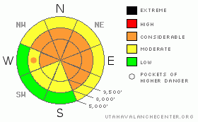
Danger Rose Tutorial
|
There is a rising avalanche danger today and tonight. A generally MODERATE avalanche danger will rise to CONSIDERABLE on steep slopes receiving about 10 or more inches of new snow or anywhere the winds increase and drift the new snow into denser slabs. The weight of a new snow slide could trigger a deep slab avalanche breaking near the ground on northwest through north through easterly facing slopes at the upper elevations. |
|
|
CURRENT CONDITIONS |

|
The storm is definitely improvising rather than following the script, and off to a slow start. Snow amounts are in the 2-6 inch range so far this morning, and temperatures are in the mid teens to low 20s. Winds have shifted from the SW to NW and are very light, averaging less than 15 mph at most locations. It will be “dust on crust” on the south ½ of the compass, with excellent powder on the northerly facing slopes at the mid and upper elevations. |
|
|
RECENT ACTIVITY |

|
No new avalanches to report from yesterday. |
|
|
THREAT #1 |

|
| WHERE |
PROBABILITY |
SIZE |
TREND |
|
|
|
|
| |
|
|
Over the next
24 hours.
|
|
|
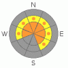
A common theme yesterday was the widespread weak surface snow, consisting of feathery surface hoar and small, loose sugary facets on the shady slopes and some surface hoar above the slick sun crusts. This buried weak snow will make the storm snow more sensitive, and it will be easy to trigger new snow sluffs. New snow soft slabs will become easier to trigger anywhere the new snow piles up or becomes wind drifted. These new snow slides could be a bit trickier than normal, as you may be able to trigger them remotely from a distance and they may break out wider than expected |
|
|
THREAT #2 |

|
| WHERE |
PROBABILITY |
SIZE |
TREND |
|
|
|
|
| |
|
|
Over the next
24 hours.
|
|
|
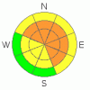
The weight of the new snow is probably not be enough to reactivate the weak layers nearer the ground, but if you trigger a new snow slide, the weight of that may be enough to step down, breaking out a deep, dangerous avalanche failing near the ground. The weak basal snow is most widespread on mid and upper elevation slopes facing northwest through north through east, and most likely to fail in shallow snow pack areas or on rocky slopes. |
|
|
MOUNTAIN WEATHER |

|
This storm system has been a tough forecast, but at the moment it looks like light to moderate snow will continue in the mountains for much of the day, especially for areas favored by northwest flow. Most locations will have storm totals of 6 to 10”. Later this afternoon through about midnight, conditions for heavier snowfall on a northwesterly flow look good for Little Cottonwood and mid Big Cottonwood, which could still have storm totals of up to 2 feet by Monday morning. Temperatures will remain in the teens and single digits today, and the northwesterly winds will remain light, averaging less than 15 mph until this afternoon, when they may pick up to 20 mph, with gusts to 30. Decreasing snow showers tonight with a break Monday, followed by a moist and windy northwest flow developing Tuesday through Thursday. |
|
|
GENERAL ANNOUNCEMENTS |
If you trigger an avalanche in the backcountry - especially if you are adjacent to a ski area – please call the following teams to alert them to the slide and whether anyone is missing or not. Rescue teams can be exposed to significant hazard when responding to avalanches, and do not want to do so when unneeded. Thanks.
Salt Lake – Alta Central (801-742-2033)
Ogden – Snowbasin Patrol Dispatch (801-620-1017)
Provo – Sundance Patrol Dispatch (801-223-4150)
Dawn Patrol Forecast Hotline, updated by 05:30: 888-999-4019 option 8.
Twitter Updates for your mobile phone http://utahavalanchecenter.org/twitter)
Daily observations are frequently posted by 10 pm each evening.
Subscribe to the daily avalanche advisory e-mail click HERE.
UDOT canyon closures UDOT at (801) 975-4838
Wasatch Powderbird Guides does daily updates about where they'll be operating on this blog http://powderbird.blogspot.com/ .
You have the opportunity to participate in the creation of our own community avalanche advisory by submitting avalanche and snow observations. You can also call us at 801-524-5304 or 800-662-4140, or email by clicking HERE
Donate to your favorite non-profit –The Friends of the Utah Avalanche Center. The UAC depends on contributions from users like you to support our work.
We will update this forecast tomorrow morning. Thanks for calling. |
|
|
This information does not apply to developed ski areas or highways where avalanche control is normally done. This advisory is from the U.S.D.A. Forest Service, which is solely responsible for its content. This advisory describes general avalanche conditions and local variations always occur. |
|
This advisory provided by the USDA Forest Service, in partnership with:
The Friends of the Utah Avalanche Center, Utah Division of State Parks and Recreation, Utah Division of Emergency Management, Salt Lake County, Salt Lake Unified Fire Authority and the friends of the La Sal Avalanche Center. See our Sponsors Page for a complete list. |
