AVALANCHE WATCH »
The risk of an avalanche is expected to increase significantly
but the timing and location are still uncertain. Stay tuned for updates.
|
 |
Notice:
An Avalanche Watch has been issued for the mountains of northern and central Utah, including the western Uintas. Heavy snowfall starting this evening and continuing through Sunday will increase the avalanche danger Sunday into Monday.
|
|
|
SPECIAL ANNOUNCEMENT |
 |
Plan ahead and save money with discount lift tickets for Alta, Snowbird, Brian Head, Sundance, and Wolf Mountain. All proceeds go towards avalanche forecasting and education.
There is a Women’s Snow and Avalanche round table this Tuesday evening at the Sandy REI, discussing current snow and avalanche conditions and careers in the snow and avalanche industry. Please register at REI HERE.
|
|
|
BOTTOM LINE
Danger by aspect and elevation on slopes approaching 35° or steeper.
(click HERE for tomorrow's danger rating)
|
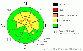
Danger Rose Tutorial
|
Today - There remain isolated Pockets of Considerable Avalanche Danger for triggering a deep slab avalanche breaking near the ground on northwest through north through easterly facing slopes at the upper elevations. A few wind drifts may have formed along the higher ridges that could also be triggered by a person.
Tomorrow - Heavy snow fall is expected overnight and on Sunday, which will increase the avalanche danger, possibly to HIGH, Sunday through Monday, especially in the Salt Lake and Provo area mountains which are forecast to receive the most snow.
|
|
|
CURRENT CONDITIONS |

|
The winds shifted to the southwest overnight ahead of an approaching storm system, and are very light this morning, averaging 5 to 15 mph. Temperatures have warmed to near 20 at 10,000’, with single digits lingering in the canyon bottom. Last night, there was a brief period of faster northwesterly winds, with speeds in the 15 to 20 mph range with gusts to 35. The snow on sunny slopes and at low elevations is crusted from sun and heat, with great riding conditions in cold powder on mid and upper elevation northerly facing slopes.
|
|
|
RECENT ACTIVITY |

|
Two new avalanches to report – one was explosive released on an upper elevation northerly facing slope releasing into old October snow – about 2’ deep by 60’ wide. The other was a snowmobile triggered new snow soft slab in American Fork, about 40 feet wide. There continue to be new observations of slides that occurred during the storm last weekend including in Broads Fork and Primrose Cirque.
|
|
|
THREAT #1 |

|
| WHERE |
PROBABILITY |
SIZE |
TREND |
|
|
|
|
| |
|
|
Over the next
10 hours.
|
|
|
The most dangerous avalanche problem continues to be the isolated chance of triggering a deep slide breaking near the ground on an upper elevation slope facing northwest through north through east, on slopes steeper than about 35 degrees. Weak spots do exist in the snow pack - think shallow, rocky areas, thinner snow pack areas, and convex slopes without support below, like a hanging snowfield. If you are getting into steep terrain, evaluate the consequences of your line – if the slope slides will you go into trees, off a cliff, into a gully or for a 2,000’ ride in addition to a possible burial? Is there a safer choice?
|
|
|
THREAT #2 |

|
| WHERE |
PROBABILITY |
SIZE |
TREND |

|
|
|
|
| |
|
|
Over the next
12 hours.
|
|
|
There is lots of loose powder available to blow around, and the overnight northwesterly winds may have created a few new soft wind drifts that will be easy to trigger on steep slopes. In addition, be alert for any increase in today’s southwesterly winds that could also drift the snow into sensitive wind slabs.
|
|
|
MOUNTAIN WEATHER |

|
A storm system will move across northern Utah tonight and Sunday, bringing periods of heavy snow, with snow showers lingering into Monday for areas favored by northwest flow. Today, there will be increasing clouds, with a slight chance for a few snow showers late in the afternoon. Temperatures will warm to near 30 at 8,000’ and remain near 20 at 10,000’. The southwesterly winds increase into the 15 to 25 mph range across the highest peaks, with gusts to 35. The front should arrive overnight, with a band of heavy snowfall developing behind the front. Snow totals in the 1 to 2 foot range by Monday morning are possible in the Cottonwoods and Provo area mountains, with about a foot expected on the Park City side and in the mountains north of I-80.
|
|
|
GENERAL ANNOUNCEMENTS |
If you trigger an avalanche in the backcountry - especially if you are adjacent to a ski area – please call the following teams to alert them to the slide and whether anyone is missing or not. Rescue teams can be exposed to significant hazard when responding to avalanches, and do not want to do so when unneeded. Thanks.
Salt Lake – Alta Central (801-742-2033)
Ogden – Snowbasin Patrol Dispatch (801-620-1017)
Provo – Sundance Patrol Dispatch (801-223-4150)
Dawn Patrol Forecast Hotline, updated by 05:30: 888-999-4019 option 8.
Twitter Updates for your mobile phone http://utahavalanchecenter.org/twitter)
Daily observations are frequently posted by 10 pm each evening.
Subscribe to the daily avalanche advisory e-mail click HERE.
UDOT canyon closures UDOT at (801) 975-4838
Wasatch Powderbird Guides does daily updates about where they'll be operating on this blog http://powderbird.blogspot.com/ .
You have the opportunity to participate in the creation of our own community avalanche advisory by submitting avalanche and snow observations. You can also call us at 801-524-5304 or 800-662-4140, or email by clicking HERE
Donate to your favorite non-profit –The Friends of the Utah Avalanche Center. The UAC depends on contributions from users like you to support our work.
We will update this forecast tomorrow morning. Thanks for calling. |
|
|
This information does not apply to developed ski areas or highways where avalanche control is normally done. This advisory is from the U.S.D.A. Forest Service, which is solely responsible for its content. This advisory describes general avalanche conditions and local variations always occur. |
|
This advisory provided by the USDA Forest Service, in partnership with:
The Friends of the Utah Avalanche Center, Utah Division of State Parks and Recreation, Utah Division of Emergency Management, Salt Lake County, Salt Lake Unified Fire Authority and the friends of the La Sal Avalanche Center. See our Sponsors Page for a complete list. |
