Salt Lake Avalanche Advisory

Forecaster: Evelyn Lees

BOTTOM LINE

Danger by aspect and elevation on slopes approaching 35° or steeper.
(click HERE for tomorrow's danger rating)


Danger Rose Tutorial

The avalanche danger remains CONSIDERABLE (Level 3) on steep upper elevation slopes facing northwest through east. Deep dangerous slides can be triggered in isolated places on slopes approaching 35 degrees or steeper. Pockets of CONSIDERABLE avalanche danger exist in similar terrain on mid elevation slopes.

Low angle shady slopes have fast turning in shallow powder, and are mostly supportable for snowmobiling.


CURRENT CONDITIONS

Under mostly cloudy skies, the light westerly winds are averaging less than 15 mph at 10,000’, and temperatures generally in the teens. Powder remains on shady mid and upper elevation slopes, with widespread crusts on the sunny aspects and at the lower elevations.


RECENT ACTIVITY

No new avalanches reported yesterday, but for the past two days there have still been major widespread collapsing as people travel into terrain with no previous traffic, including upper Mill Creek and Mt Aire.


THREAT #1

WHERE PROBABILITY SIZE TREND
      Over the next 24 hours.

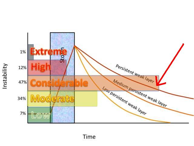
To me, the above chart from Bruce’s book “Staying Alive in Avalanche Terrain” depicts the current stability trend. The upper line shows the slow stabilization of a well developed persistent weak layer of faceted snow after a storm. Not only is the trend slower than we are used to here in the Wasatch, it also shows that perhaps snowpack never completely stabilizes - there will always be some sort of doubt as to stability and the chance of triggering a slide with a buried layer of faceted snow.

So - as the slab strengthens, the probability of triggering a deep slide on the facets is decreasing each day, but if you do trigger a slide, the consequence are still high – it could be deadly. The most likely place to trigger one of these slides is from a rocky or shallow snowpack area, where the slab is thinner or the facets are weaker, and avoiding the steep, west through north through east facing slopes avoids the problem.

Slopes that slid late in the storm are becoming a choice for turning and riding, but this takes expert level evaluation. “Repeaters” can happen – some slopes that slid early in the storm cycle have filled in enough that they can be triggered again, especially where wind drifted.


MOUNTAIN WEATHER

An approaching cold front will bring our last chance for snow in the near future. Clouds will gradually increase throughout the day, with light snow fall possible by late afternoon. 8,000’ highs will be in the low 30s and 10,000’ highs in the low 20s. The southwesterly winds will remain light, averaging less than 15 mph at 10,000’, with the highest peaks reaching 25 mph averages. Periods of light snow tonight, with snow totals of 2 to 5 inches are expected. Lingering clouds Thursday into Friday, with occasional snow flurries. Strong high pressure will return for the weekend, and looks to remain in place over Utah through all of next week.


GENERAL ANNOUNCEMENTS

If you trigger an avalanche in the backcountry - especially if you are adjacent to a ski area – please call the following teams to alert them to the slide and whether anyone is missing or not. Rescue teams can be exposed to significant hazard when responding to avalanches, and do not want to do so when unneeded. Thanks.

Salt Lake – Alta Central (801-742-2033)

Ogden – Snowbasin Patrol Dispatch (801-620-1017)

Provo – Sundance Patrol Dispatch (801-223-4150)

Dawn Patrol Forecast Hotline, updated by 05:30: 888-999-4019 option 8.

Twitter Updates for your mobile phone http://utahavalanchecenter.org/twitter)

Daily observations are frequently posted by 10 pm each evening.

Subscribe to the daily avalanche advisory e-mail click HERE.

UDOT canyon closures UDOT at (801) 975-4838

Wasatch Powderbird Guides does daily updates about where they'll be operating on this blog http://powderbird.blogspot.com/ .

You have the opportunity to participate in the creation of our own community avalanche advisory by submitting avalanche and snow observations. You can also call us at 801-524-5304 or 800-662-4140, or email by clicking HERE

Donate to your favorite non-profit –The Friends of the Utah Avalanche Center. The UAC depends on contributions from users like you to support our work.

We will update this forecast tomorrow morning. Thanks for calling.


This information does not apply to developed ski areas or highways where avalanche control is normally done.  This advisory is from the U.S.D.A. Forest Service, which is solely responsible for its content. This advisory describes general avalanche conditions and local variations always occur.


This advisory provided by the USDA Forest Service, in partnership with:

The Friends of the Utah Avalanche Center, Utah Division of State Parks and Recreation, Utah Division of Emergency Management, Salt Lake County, Salt Lake Unified Fire Authority and the friends of the La Sal Avalanche Center. See our Sponsors Page for a complete list.