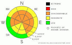
BOTTOM LINE
Danger by aspect and elevation on slopes approaching 35° or steeper.
(click HERE for tomorrow's danger rating)
|
Danger Rose Tutorial
|
There is a CONSIDERABLE avalanche danger for triggering both deep slab avalanches and new wind drifts. CONSIDERABLE is just one notch below HIGH, and means that dangerous avalanche conditions exist, and human triggered slides are likely. The slopes of concern are steep, mid and upper elevation slopes facing west through north through southeast, especially where wind drifted. Triggered slides could be 2 to 5 feet deep. If the snow gets damp where you are, avoid the steep slopes.
There is great powder for turning and riding on shady, upper elevation low angle slopes.
With more snow on the way, and strong winds around frontal passage, the avalanche danger will increase late this afternoon through overnight, especially in the mountains north of I-80. If you’re heading out early tomorrow, out early line (888-999-4019 option 8) is updated by 5 am.
|
|
|
CURRENT CONDITIONS |

|
Under a mild westerly flow, skies are partly cloudy and temperatures continue to be warm this morning, mostly in the low to upper twenties. The winds are in the process of shifting to the southwest, and have significantly decreased along the higher ridges – even the exposed stations are only averaging 10 to 20 mph, with gusts to 30 this morning.
There is still excellent riding, turning and snowshoeing in powder on low angle shady slopes at the higher elevations. Many of the sunny slopes are now crusted, and the snow got damp on all aspects in some low to mid elevation drainages, with reports of thin rain, rime and heat crusts.
|
|
|
RECENT ACTIVITY |

|
 No new backcountry avalanches were reported yesterday, though we now have information about 2 very close calls from Tuesday the 24th. A snowmobile triggered slide on Whiskey Hill in the Ogden area mountains, and a classic delayed release to the side of Square Top, probably triggered by skiers, which took out at least 10 sets of tracks (above photo, by Jeff Lonn). Details on our avalanche list. Ski area explosive control work in Big Cottonwood was still releasing full depth, 80’ wide avalanches, and one slide was remotely triggered from a ridge line. No new backcountry avalanches were reported yesterday, though we now have information about 2 very close calls from Tuesday the 24th. A snowmobile triggered slide on Whiskey Hill in the Ogden area mountains, and a classic delayed release to the side of Square Top, probably triggered by skiers, which took out at least 10 sets of tracks (above photo, by Jeff Lonn). Details on our avalanche list. Ski area explosive control work in Big Cottonwood was still releasing full depth, 80’ wide avalanches, and one slide was remotely triggered from a ridge line.
|
|
|
THREAT #1 |

|
| WHERE |
PROBABILITY |
SIZE |
TREND |

|
|
|
|
| |
|
|
Over the next
24 hours.
|
|
|
The greatest avalanche danger remains the chance of triggering a 2 to 5 foot deep slide, breaking on the weak facets. As time goes on, these slabs become more stubborn and harder to trigger, but still have the potential to be deadly. They can break out above you, and not always on the first person. Avoid the steep mid and upper elevation slopes, including mid slope rollovers, aprons beneath cliffs, and especially slopes where the snow from an avalanche could pile up in a gully or other terrain trap. Avalanches can still be triggered remotely from a distance, and from below.
Most of the avalanches that ran this past week did not clean out the advanced facets near the ground, and as these slide paths get reloaded with wind blown snow or tonight’s storm snow, they may be ready to repeat – a second avalanche cycle on the same slope.
|
|
|
THREAT #2 |

|
| WHERE |
PROBABILITY |
SIZE |
TREND |

|
|
|
|
| |
|
|
Over the next
24 hours.
|
|
|
Yesterday’s strong west to northwesterly winds created new dense wind drifts along the higher ridges, which should be avoided today on any steep slope. Drifts will be most widespread on slopes with an easterly component, and some drifts could be mid slope. These drifts will become more widespread later today and tonight, whenever the winds increase and the snow start falling where you are.
|
|
|
MOUNTAIN WEATHER |

|
Northern Utah will be under an increasingly moist southwest flow ahead of a Pacific cold front which will cross northern Utah this evening. Increasing clouds today, with snow starting before noon north of I-80, and this afternoon south of I-80. Temperatures will be very warm once again, in the upper 30’s at 8,000’ and near 30 at 10,000’. The southwesterly winds will be light today, until near frontal passage, when 3 to 6 hours of strong, southwest to northwesterly winds could occur. Over a foot of snow is possible north of I-80, and up to a foot south of I-80. Warm and dry for the weekend.
|
|
|
GENERAL ANNOUNCEMENTS |
|
Salt Lake – Alta Central (801-742-2033)
Ogden – Snowbasin Patrol Dispatch (801-620-1017)
Provo – Sundance Patrol Dispatch (801-223-4150)
Dawn Patrol Forecast Hotline, updated by 05:30: 888-999-4019 option 8.
Daily observations are frequently posted by 10 pm each evening.
Subscribe to the daily avalanche advisory e-mail click HERE.
UDOT canyon closures UDOTat (801) 975-4838
Wasatch Powderbird Guides does daily updates about where they'll be operating on this blog http://powderbird.blogspot.com/ .
You have the opportunity to participate in the creation of our own community avalanche advisory by submitting avalanche and snow observations. You can also call us at 801-524-5304 or 800-662-4140, or email by clicking HERE
Donate to your favorite non-profit –The Friends of the Utah Avalanche Center. The UAC depends on contributions from users like you to support our work.
We will update this forecast tomorrow morning. Thanks for calling.
|
|
|
This information does not apply to developed ski areas or highways where avalanche control is normally done. This advisory is from the U.S.D.A. Forest Service, which is solely responsible for its content. This advisory describes general avalanche conditions and local variations always occur. |
|
This advisory provided by the USDA Forest Service, in partnership with:
The Friends of the Utah Avalanche Center, Utah Division of State Parks and Recreation, Utah Division of Emergency Management, Salt Lake County, Salt Lake Unified Fire Authority and the friends of the La Sal Avalanche Center. See our Sponsors Page for a complete list. |
