Salt Lake Avalanche Advisory

Forecaster: Brett Kobernik

AVALANCHE WARNING »

Dangerous avalanche conditions are occuring or are imminent. Backcountry travel in avalanche terrain is not recommended.
Notice:

The avalanche warning continues for all the mountains of northern Utah. Deadly human triggered avalanches continue to be very likely on steeper slopes. Avalanches can be triggered from a distance so stay out from underneath steep slopes as well. People without expert level backcountry avalanche skills are urged to stay out of the backcountry.


BOTTOM LINE

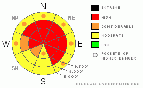
Danger by aspect and elevation on slopes approaching 35° or steeper.
(click HERE for tomorrow's danger rating)


Danger Rose Tutorial

The avalanche danger is HIGH. Human triggered avalanches on mid and upper elevation slopes that face west through north through east are very likely still. Avalanches can be triggered from a distance so stay out from underneath these slopes as well. Low angle terrain continues to be the choice of the well versed backcountry traveler.


CURRENT CONDITIONS

Under light snow, temperatures are in the low teens with a few stations in the low 20s with light northwest winds. About 4 inches of snow fell since Monday in most areas from Ogden through the Salt Lake mountains and into the Provo region. Riding conditions are good and trailbreaking manageable. The slab is settling into a more dense unit making sled travel possible in many more areas now.


RECENT ACTIVITY

Snow safety teams are up against it right now dealing with these very hazardous conditions. There were a couple of close calls on Monday where one patroller was caught and carried and another had an avalanche break above him and was able to retain a “death grip” on a tree as the avalanche washed over him. There were no significant injuries.

In the backcountry, two avalanches from Monday are worth noting. Mark White continues his personal avalanche mitigation mission of West Monitor by pulling out a 3 to 6 foot deep pencil hardslab with a cornice kick. This was a repeater. See Marla's video of this releasing: DETAILS

Dutch’s Draw released naturally sometime early Monday morning. Wind loading is the most likely trigger. This was a repeater as well. All photos: White

Jan 19

Jan 24


THREAT #1

WHERE PROBABILITY SIZE TREND
      Over the next 24 hours.

Avalanches breaking into weak snow from earlier in the season remains your number one concern today. No one who has an intimate knowledge of snow is getting onto steep slopes. Collapsing is becoming less frequent and things are not as sensitive as a couple days back. We will move into a lower probability / high consequence situation - the worst to forecast for. The take home is you can’t trust a faceted persistent weak layer ESPECIALLY one like many of us have never seen or dealt with. Let it be for a while.


MOUNTAIN WEATHER

Snowfall in the mountains should trickle to a stop this morning and skies may break a bit as the day goes on. High temperatures should get into the upper teens along the ridges and mid 20s at 8000 feet. North winds should remain fairly light. We could see light snow showers at times Wednesday and Thursday with another little refresher storm on Friday.


GENERAL ANNOUNCEMENTS

Salt Lake – Alta Central (801-742-2033)

Ogden – Snowbasin Patrol Dispatch (801-620-1017)

Provo – Sundance Patrol Dispatch (801-223-4150)

Dawn Patrol Forecast Hotline, updated by 05:30: 888-999-4019 option 8.

Daily observations are frequently posted by 10 pm each evening.

Subscribe to the daily avalanche advisory e-mail click HERE.

UDOT canyon closures UDOTat (801) 975-4838

Wasatch Powderbird Guides does daily updates about where they'll be operating on this blog http://powderbird.blogspot.com/ .

You have the opportunity to participate in the creation of our own community avalanche advisory by submitting avalanche and snow observations. You can also call us at 801-524-5304 or 800-662-4140, or email by clicking HERE

Donate to your favorite non-profit –The Friends of the Utah Avalanche Center. The UAC depends on contributions from users like you to support our work.

We will update this forecast tomorrow morning. Thanks for calling.


This information does not apply to developed ski areas or highways where avalanche control is normally done.  This advisory is from the U.S.D.A. Forest Service, which is solely responsible for its content. This advisory describes general avalanche conditions and local variations always occur.


This advisory provided by the USDA Forest Service, in partnership with:

The Friends of the Utah Avalanche Center, Utah Division of State Parks and Recreation, Utah Division of Emergency Management, Salt Lake County, Salt Lake Unified Fire Authority and the friends of the La Sal Avalanche Center. See our Sponsors Page for a complete list.