AVALANCHE WATCH »
The risk of an avalanche is expected to increase significantly
but the timing and location are still uncertain. Stay tuned for updates.
|
 |
Notice: We will be issuing an Avalanche Watch today - a major winter storm arriving tomorrow, Wednesday, will bring an extended period of snow, rain and strong winds to the northern Utah mountains. The heavy new snow will be landing on an extremely weak snowpack, and there will be very dangerous avalanche conditions throughout the backcountry, including almost all the Wasatch ice climbs, which are in avalanche tracks. Continue to check the Utah Avalanche Center and the National Weather Service for the latest information on avalanche and weather conditions. |
|
|
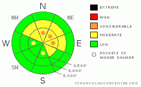
BOTTOM LINE
Danger by aspect and elevation on slopes approaching 35° or steeper.
(click HERE for tomorrow's danger rating)
|
Danger Rose Tutorial
|
There is an overall MODERATE avalanche danger with Pockets of CONSIDERABLE danger for triggering an old or new wind slab or wind drift on steep, upper elevation slopes facing northwest through east. Getting caught in any slide will have severe consequences, due to the likelihood of hitting rocks as you get carried down the slope. Heavy snowfall, strong winds and warming temperatures will rapidly increase the avalanche danger starting tomorrow. |
|
|
CURRENT CONDITIONS |

|
 Behind the cold front, temperatures continued to drop overnight, and most stations are reading between zero and 10 below this morning, with the Ogden mountains in positive territory, in the single digits above zero. Luckily, the winds decreased – they’ve shifted to the southwest, and most stations are averaging less than 15 mph, with only the highest peaks averaging to 25 mph. Snow totals from yesterday ended up in the zero to 3” range, so turning, snowshoeing and riding conditions are more of the same – a thin snowpack mix of ice crusts, hard wind drifts, and punchy weak snow over rocks and logs. “Slide for life” conditions exist on some of the steep, icy slopes. Behind the cold front, temperatures continued to drop overnight, and most stations are reading between zero and 10 below this morning, with the Ogden mountains in positive territory, in the single digits above zero. Luckily, the winds decreased – they’ve shifted to the southwest, and most stations are averaging less than 15 mph, with only the highest peaks averaging to 25 mph. Snow totals from yesterday ended up in the zero to 3” range, so turning, snowshoeing and riding conditions are more of the same – a thin snowpack mix of ice crusts, hard wind drifts, and punchy weak snow over rocks and logs. “Slide for life” conditions exist on some of the steep, icy slopes.
|
|
|
RECENT ACTIVITY |

|
Yesterday, there was cracking and even a very small inconsequential slide in the shallow wind drifts of new snow. Also a late report came in from the 15th, of a slide coming down one of the ice gullies to the east of the Y-couloir in Little Cottonwood, over running two climbers who were luckily anchored at the time. |
|
|
THREAT #1 |

|
| WHERE |
PROBABILITY |
SIZE |
TREND |

|
|
|
|
| |
|
|
Over the next
24 hours.
|
|
|
While much of the snow pack consists of weak, unconsolidated snow, there are still isolated places where slides could be triggered, with an old or new wind drift acting as the slab. The most likely place would be on a steep shady upper elevation slope, facing northwest through east. Any cracking or collapsing is and indication that you’re in an area where there is enough weight or a slab that an avalanche could be triggered. Elsewhere, the weak faceted snow is widespread, but missing any slab.
Of note, with an upcoming storm, is the snowpack on many of the more southerly facing slopes is nothing to brag about – it consists of ice crust and facet sandwiches, weaker on lower angle slopes and slopes with a more easterly component. |
|
|
MOUNTAIN WEATHER |

|
The count down continues…one more day of dry high pressure before the big change tomorrow. Today, under a dry southwesterly flow, skies will be partly cloudy and temperatures will warm into the single digits and teens. The winds will be light, averaging generally less than 15 mph, with the highest peaks averaging up to 25 mph. Increasing wind speeds tonight, as a strong and moist zonal westerly flow develops, creating an extended period of precipitation. Snow will start near the Idaho border tomorrow morning, and spread south, with heavy snowfall reaching the mountains south of I-80 in the afternoon or evening. Dense snow with high water content and fluctuating temperatures with a warming trend will all be adding to the snowpack instability over the next week. |
|
|
GENERAL ANNOUNCEMENTS |
If you trigger an avalanche in the backcountry - especially if you are adjacent to a ski area – please call the following teams to alert them to the slide and whether anyone is missing or not. Rescue teams can be exposed to significant hazard when responding to avalanches, and do not want to do so when unneeded. Thanks.
Salt Lake – Alta Central (801-742-2033)
Ogden – Snowbasin Patrol Dispatch (801-620-1017)
Provo – Sundance Patrol Dispatch (801-223-4150)
Dawn Patrol Forecast Hotline, updated by 05:30: 888-999-4019 option 8.
Daily observations are frequently posted by 10 pm each evening.
Subscribe to the daily avalanche advisory e-mail click HERE.
UDOT canyon closures UDOTat (801) 975-4838
Wasatch Powderbird Guides are suspending the opening of helicopter skiing operations. Once we have enough snow cover, daily updates to this bloghttp://powderbird.blogspot.com/will begin for the 2011-2012 season.
You have the opportunity to participate in the creation of our own community avalanche advisory by submittingavalanche and snow observations. You can also call us at 801-524-5304 or 800-662-4140, or email by clickingHERE
Donate to your favorite non-profit –The Friends of the Utah Avalanche Center. The UAC depends on contributions from users like you to support our work.
We will update this forecast tomorrow morning. Thanks for calling. |
|
|
This information does not apply to developed ski areas or highways where avalanche control is normally done. This advisory is from the U.S.D.A. Forest Service, which is solely responsible for its content. This advisory describes general avalanche conditions and local variations always occur. |
|
This advisory provided by the USDA Forest Service, in partnership with:
The Friends of the Utah Avalanche Center, Utah Division of State Parks and Recreation, Utah Division of Emergency Management, Salt Lake County, Salt Lake Unified Fire Authority and the friends of the La Sal Avalanche Center. See our Sponsors Page for a complete list. |
