Salt Lake Avalanche Advisory

Forecaster: Evelyn Lees

AVALANCHE WARNING »

Dangerous avalanche conditions are occuring or are imminent. Backcountry travel in avalanche terrain is not recommended.
Notice:

This is an Avalanche Warning for the mountains of northern and central Utah including the Western Uintas. Heavy snowfall on an extremely weak snowpack has created a HIGH Avalanche Danger. Large dangerous avalanches can be triggered on steep slopes and from a distance. Backcountry travel is not recommended.


BOTTOM LINE

Danger by aspect and elevation on slopes approaching 35° or steeper.
(click HERE for tomorrow's danger rating)


Danger Rose Tutorial

The Avalanche Danger is HIGH on steep mid and upper elevation slopes facing northwest through east, especially slopes that receive 10 or more inches of snow, that are wind drifted or have snow pooled, such as below cliffs and gullies. Avalanches breaking out one to two feet deep and over 150 feet wide can be triggered. Backcountry travel on, below and adjacent to steep avalanche terrain is not recommended.


CURRENT CONDITIONS

Finally – a snow producing storm! As of 6 am, about 2 to 5” of snow has fallen, with up to 1/3 of an inch of water, and moderate snowfall is continuing as a second piece of the storm moves across northern Utah. The northwesterly winds are averaging up to 15 mph, with gusts in the 20’s. The highest peaks averaged in the 20’s with gusts into the 30s and 40s for a few hours overnight. It is a welcome shot of snow, but in many locations it’s just dust on crust…and will rehide the rocks, dirt and logs.


RECENT ACTIVITY

No new avalanches reported yesterday, but there have been excellent observations for days from the northern and central Utah mountains focused on the weak snow pack. Check out the Current Conditions page, and remember that you can sort by region.


THREAT #1

WHERE PROBABILITY SIZE TREND
      Over the next 12 hours.

In Utah, we rarely get excited about 6 to 10 inches of snow, with a ½ inch of water weight. But rarely do we have such a weak snowpack, made up of extremely fragile faceted crystals with a few ice crusts and thin hard wind slabs thrown in. We are now developing a slab on our weak layer – maybe not enough snow to produce a widespread natural cycle, but enough snow that the additional weight of a person can trigger avalanches.

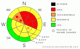
· Avalanches can be triggered on the shady, steep northwest, north, northeast and easterly facing slopes, 1 to 2 feet deep and over 200’ wide. Natural avalanches may occur.

· Slides can be triggered remotely from a distance today - do not cross below steep terrain and avoid terrain adjacent to steep slopes.

· Once moving, any avalanche will gouge and entrain the loose, weak snow, and debris piles will be much deeper than one would expect.

· Don’t be fooled by the old wind hammered snow right along ridgelines – the weakest snow and trigger points may be off the ridges, allowing avalanches release mid slope and break out above you.

· The recent crusts and wind slabs may support a bit more snow weight before breaking, but result in a deeper, wider slide.

· Snow may also roll off of and pool beneath cliffs and at the base of gullies, and slides could break out on lower angle slopes in these heavily loaded areas.

· Snow pack is still shallow, and any ride in an avalanche could result in both trauma and burial.

· Recent avalanches, cracking or collapsing (a whoomphing noise) are red flags – the snow pack is unstable - stay off and out from under steep slopes.


MOUNTAIN WEATHER

The Pacific storm system will intensify as it moves through Utah today, allowing snow to continue into the early afternoon. The heaviest snowfall intensities will be through late morning, with an additional 3 to 6” possible today. Storm totals of 5 to 11 inches with over a ½ inch of water are possible in the mountains of northern and central Utah, with areas favored by northwest flow receiving the high end amounts. Temperatures will be much cooler – near 20 at 8,000’ and in the low teens at 10,000’. The northwesterly winds will average 10 to 15 mph, with gusts in the 20s at the mid elevations, with speeds across the most exposed terrain averaging up to 25 mph. High pressure will build back in starting tonight, with snowfall rapidly ending, and temperatures warming significantly Sunday afternoon and Monday.


GENERAL ANNOUNCEMENTS

If you trigger an avalanche in the backcountry - especially if you are adjacent to a ski area – please call the following teams to alert them to the slide and whether anyone is missing or not. Rescue teams can be exposed to significant hazard when responding to avalanches, and do not want to do so when unneeded. Thanks.

Salt Lake – Alta Central (801-742-2033)

Ogden – Snowbasin Patrol Dispatch (801-620-1017)

Provo – Sundance Patrol Dispatch (801-223-4150)

Dawn Patrol Forecast Hotline, updated by 05:30: 888-999-4019 option 8.

Daily observations are frequentlypostedby 10 pm each evening.

Subscribe to the daily avalanche advisory e-mail clickHERE.

UDOT canyon closuresUDOTat (801) 975-4838

Wasatch Powderbird Guides are suspending the opening of helicopter skiing operations. Once we have enough snow cover, daily updates to this bloghttp://powderbird.blogspot.com/will begin for the 2011-2012 season.

You have the opportunity to participate in the creation of our own community avalanche advisory by submittingavalanche and snow observations. You can also call us at 801-524-5304 or 800-662-4140, or email by clickingHERE

Donate to your favorite non-profit –The Friends of the Utah Avalanche Center. The UAC depends on contributions from users like you to support our work.

We will update this forecast tomorrow morning. Thanks for calling..


This information does not apply to developed ski areas or highways where avalanche control is normally done.  This advisory is from the U.S.D.A. Forest Service, which is solely responsible for its content. This advisory describes general avalanche conditions and local variations always occur.


This advisory provided by the USDA Forest Service, in partnership with:

The Friends of the Utah Avalanche Center, Utah Division of State Parks and Recreation, Utah Division of Emergency Management, Salt Lake County, Salt Lake Unified Fire Authority and the friends of the La Sal Avalanche Center. See our Sponsors Page for a complete list.