Provo Avalanche Advisory

Forecaster: Drew Hardesty

BOTTOM LINE

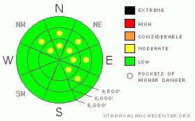
Danger by aspect and elevation on slopes approaching 35° or steeper.
(click HERE for tomorrow's danger rating)


Danger Rose Tutorial

Pockets of Moderate danger exist. Human triggered slides remain possible in steep northwest through southeast facing terrain. Avoid any obvious smooth rounded pillows of snow and be alert to even the slightest audible collapsing in the snowpack. REMOTELY TRIGGERED SLIDES REMAIN POSSIBLE IN ISOLATED TERRAIN. Consider what's above you and how this may affect your perceived safe zones at the bottom.

As with the definition of MODERATE - "Heightened avalanche conditions on specific terrain features. Evaluate snow and terrain carefully; identify features of concern."


CURRENT CONDITIONS

Beautiful weather. Ain't it a shame? Mountain temps are again inverted with trailheads in the mid-teens, ridgelines in the mid-20s. The west to northwesterlies are blowing 15-20mph with gusts to 30. Riding conditions are an entertaining mix of sun and wind crust, boilerplate wind slab, and patches of soft nearly unsupportable recrystallized snow. Mid to high elevation northerly slopes have 2-3' of snow. Southerly aspects range from dry to 1'. Snowmobiles will easily bottom out in the thin coverage; snowshoes, skins and fish-scales will have increasing difficulty gaining traction in the sugar snow.

Shaping up to be the leanest winter since 1976 when they had only 30.5" total for the months of Nov/Dec. By all rights, we're sitting pretty good at 70" - good enough for 4th place since 1945. Remember 4th isn't even on the podium.


RECENT ACTIVITY

We heard no reports of any activity in the Provo area mountains, but in the Central Wasatch -

Just a little bit of wind... Cracking, collapsing, some avalanching...it's a little like playing poker with my 9 year old - I can tell what cards he's holding and he can't bluff his way out of a paper bag.

We heard of one remotely triggered slide, and at least one person and probably two (in separate incidents) were caught and carried by small wind slabs they initiated. I collapsed and cracked out plenty of new and old shallowish wind drifts as well. The details -

· In the Brighton backcountry above Lackawaxen basin, a party on their 2nd lap remotely triggered a 8” deep and 20’ wide soft slab that gouged and entrained faceted snow on its way down. Would’ve been a nasty ride.

· Just off the West Desolation ridgeline in upper Mill D North of Big Cottonwood, a skier initiated a sluff that in turn triggered a 10” deep and 60’ wide soft slab. The skier was carried nearly 200’ and was partially buried but was otherwise ok.

· We had a 2nd hand report of another skier caught and carried in a shallow soft slab he triggered along the northern Brighton periphery. It too reportedly gouged down into older faceted snow.

You can find photos and more from yesterday on our Current Conditions page (The good stuff) there in the upper left hand corner beneath our logo. In the Ogden area mountains, Brandon Everett has some of the better photos of buried, intact surface hoar I've seen in awhile.


THREAT #1

WHERE PROBABILITY SIZE TREND
      Over the next 24 hours.

Old and new wind drifts may still be triggered in localized terrain. Many of these "wind slabs" or drifts...or even slight consolidation of old storm snow... bond poorly to some of the weakest snow we've seen in years. Some of these slabs are "fist-hard" (paperon hand hardness scale - see page 2 & 3) and don't even seem like a slab - yet they are.

Cracking, collapsing, remotely triggered slides are all tell-tale signs of instability. There is quite a bit of slope to slope variability. Many drifts I found were well off the ridge line and even mid-elevation. At one point I changed my up-track route due to the presence of obvious wind slab.

That's the conundrum of Moderate - the avalanche problem is not widespread nor are they particularly large (all less than 10" deep). Snow tests may produce variable results. Remain disciplined with your safe travel protocol and if your risk acceptance is low, ratchet down your slope angles.


THREAT #2

WHERE PROBABILITY SIZE TREND
      Over the next 24 hours.

The insanely weak rotten snow simply pours out of the pit wall upon excavation. Loose facet-sluff avalanches can still be triggered in steep northerly terrain and may be a able to gouge down and entrain a fair amount of the existing snow on the ground on its way to the flats. Sluffs are typically "manageable" hazards but there is still the likelihood of getting tripped up by the rocks and stumps poking through the threadbare coverage.


MOUNTAIN WEATHER

Clear skies will yield to increasing clouds ahead of a warm and moist westerly flow through the rest of the week. 8000' and 10,000' temps will be in the mid 30s and mid 20s. The northwest winds are expected to be 20-25mph along the highest ridgelines but generally light in the more protected terrain. May see a flurry or two by the afternoon. It looks like Logan and areas north will receive the bulk of the storms through the week while the Central and Southern Wasatch are again forced to scavenge the leftover table scraps.


GENERAL ANNOUNCEMENTS

If you trigger an avalanche in the backcountry - especially if you are adjacent to a ski area – please call the following teams to alert them to the slide and whether anyone is missing or not. Rescue teams can be exposed to significant hazard when responding to avalanches, and do not want to do so when unneeded. Thanks.

Salt Lake – Alta Central (801-742-2033)

Ogden – Snowbasin Patrol Dispatch (801-620-1017)

Provo – Sundance Patrol Dispatch (801-223-4150)

Dawn Patrol Forecast Hotline, updated by 05:30: 888-999-4019 option 8.

Daily observations are frequently posted by 10 pm each evening.

Subscribe to the daily avalanche advisory e-mail clickHERE.

UDOT canyon closures UDOTat (801) 975-4838

You have the opportunity to participate in the creation of our own community avalanche advisory by submitting avalanche and snow observations. You can also call us at 801-524-5304 or 800-662-4140, or email by clickingHERE

Donate to your favorite non-profit –The Friends of the Utah Avalanche Center. The UAC depends on contributions from users like you to support our work.

We will update this forecast tomorrow morning. Thanks for calling.


This information does not apply to developed ski areas or highways where avalanche control is normally done.  This advisory is from the U.S.D.A. Forest Service, which is solely responsible for its content. This advisory describes general avalanche conditions and local variations always occur.


This advisory provided by the USDA Forest Service, in partnership with:

The Friends of the Utah Avalanche Center, Utah Division of State Parks and Recreation, Utah Division of Emergency Management, Salt Lake County, Salt Lake Unified Fire Authority and the friends of the La Sal Avalanche Center. See our Sponsors Page for a complete list.