SPECIAL ANNOUNCEMENT |
 |
Stocking stuffers! We now have discount lift tickets available. Go to our Online Store or click this PURCHASE LINK to Backcountry.com who is distributing them for us. You can show your support by purchasing UAC hardgoods (great xmas gifts!!) through our Online Store from the main menu above. We offer free shipping on everything.
On Thursday at 6pm at the SnowbirdIron Blosam Lodge in the Wildflower Lounge,Tyson Bradley will present A Climb in the Khumbu about hisrecent return to the Khumbu region of Nepal and climbing attempt of a Himalayan giant.There will be a drawing for gear, with proceeds benefiting the Utah Avalanche Center. Must be 21. Detailshere |
|
|
BOTTOM LINE
Danger by aspect and elevation on slopes approaching 35° or steeper.
(click HERE for tomorrow's danger rating)
|
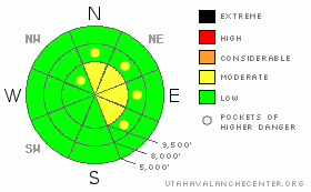
Danger Rose Tutorial
|
The danger is expected to rise to MODERATE (Level 2) in terrain that receives snow and wind. New wind drifts will be most pronounced on steep north through southeast facing terrain at the mid and upper elevations. While shallow, these drifts may catch you off guard by breaking out above you. Again, consider the consequences of getting dragged down even in a small slide today. |
|
|
CURRENT CONDITIONS |

|
Just the first few flakes are falling in the mountains this morning ahead of today's cold, if unimpressively dry, storm. The west-northwesterly winds picked up around midnight and are blowing 15-20mph with gusts to 30 at most stations. Along the 11,000' ridgelines, however, they've increased to 30-35mph with gusts toward 60. Mountain temperatures are in the teens across the board. The good news is that the smog across the valleys will be gone. |
|
|
RECENT ACTIVITY |

|
Continued reports of intentionally triggered sluffs in the weak sugary snow in the steepest rocky terrain.
Check out Kobernik's excellent video of his field day yesterday. (As an aside, it would be difficult to overstate what this old Michigan farmer/welder has meant to the UAC over the years - it's good to work with him.) Current conditions in the upper left hand side of the page has many new reports, especially in the Provo mountains. |
|
|
THREAT #1 |

|
| WHERE |
PROBABILITY |
SIZE |
TREND |

|
|
|
|
| |
|
|
Over the next
24 hours.
|
|
|
The snowpack is ready and primed to avalanche - IF we get some snow and wind. The wind will certainly play more of a role with this system - but I fear it won't take much. A few inches and some drifting will EASILY create very sensitive shallow wind slabs. They may be on the smallish side, but they ought to make up for it by being potentially hair-trigger and perhaps breaking above you. Any moving debris may "step down" and gouge into the sugary "mid-pack", resulting in a more significant slide. |
|
|
THREAT #2 |

|
| WHERE |
PROBABILITY |
SIZE |
TREND |

|
|
|
|
| |
|
|
Over the next
24 hours.
|
|
|
As evidenced yesterday in the steep Wolverine area, sluffing in the weak faceted snow continues to be a possibility. Consider the consequences of even getting knocked off your feet and dragged down. Brandon Dodge has an excellentobservation- his second photo paints the picture of terrain and consequences - and what taking a nasty ride would look like. Traumatic injury is a sure thing here. |
|
|
MOUNTAIN WEATHER |

|
Snow flurries this morning, snow flurries through the afternoon. It may add up to 5" if we're lucky. Mountain temps will drop into the single digits by tonight. The gusty northerly winds will blow 20-25mph today - and a bit higher along the more exposed ridgelines. The storm should clear out by mid-morning tomorrow. A ridge of high pressure builds through the weekend with the next potential bust about a week out. |
|
|
GENERAL ANNOUNCEMENTS |
If you trigger an avalanche in the backcountry - especially if you are adjacent to a ski area – please call the following teams to alert them to the slide and whether anyone is missing or not. Rescue teams can be exposed to significant hazard when responding to avalanches, and do not want to do so when unneeded. Thanks.
Salt Lake – Alta Central (801-742-2033)
Ogden – Snowbasin Patrol Dispatch (801-620-1017)
Provo – Sundance Patrol Dispatch (801-223-4150)
Dawn Patrol Forecast Hotline, updated by 05:30: 888-999-4019 option 8.
Daily observations are frequentlypostedby 10 pm each evening.
Subscribe to the daily avalanche advisory e-mail clickHERE.
UDOT canyon closuresUDOTat (801) 975-4838
You have the opportunity to participate in the creation of our own community avalanche advisory by submittingavalanche and snow observations. You can also call us at 801-524-5304 or 800-662-4140, or email by clickingHERE
Donate to your favorite non-profit –The Friends of the Utah Avalanche Center. The UAC depends on contributions from users like you to support our work.
We will update this forecast tomorrow morning. Thanks for calling.
|
|
|
This information does not apply to developed ski areas or highways where avalanche control is normally done. This advisory is from the U.S.D.A. Forest Service, which is solely responsible for its content. This advisory describes general avalanche conditions and local variations always occur. |
|
This advisory provided by the USDA Forest Service, in partnership with:
The Friends of the Utah Avalanche Center, Utah Division of State Parks and Recreation, Utah Division of Emergency Management, Salt Lake County, Salt Lake Unified Fire Authority and the friends of the La Sal Avalanche Center. See our Sponsors Page for a complete list. |
