SPECIAL ANNOUNCEMENT |
 |
Note: with the combination of drought and smoggy conditions, we are telecommuting, which is why we don't answer our office phone. But we check the messages each morning. We have also dramatically cut back on field time to catch up on projects but we will update critical information most mornings on the web and phone lines.
We now have discount lift tickets available. Go to our Online Store or click this PURCHASE LINK to Backcountry.com who is distributing them for us.
You can show your support by purchasing UAC hardgoods (great xmas gifts!!) through our Online Store from the main menu above. We offer free shipping on everything.
WE WILL UPDATE THIS ADVISORY SUNDAY MORNING. |
|
|
BOTTOM LINE
Danger by aspect and elevation on slopes approaching 35° or steeper.
(click HERE for tomorrow's danger rating)
|
Danger Rose Tutorial
|
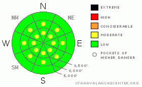
There are Pockets of MODERATE avalanche danger for triggering shallow soft slabs and for triggering one of the increasingly large loose snow sluffs on steep mid and upper elevation terrain, facing northwest through southeast. Damp sluffs may become possible on the steep, sunny slopes. Slope cuts are ineffective when hitting rocks and becoming stopped in your track. While small, all these slides are large enough to catch and carry a person, and any ride will be rough and dangerous, involving hitting rocks. |
|
|
CURRENT CONDITIONS |

|
Under clear skies, a mild southwest flow has ramped up the temperatures even a bit more this morning, with mid and upper elevations reading in the low to mid 30s. Some stations had no overnight refreeze. Temperatures in the canyon bottoms, however, are lingering in the teens this morning due to the inversion. The southwesterly winds are light, generally less than 15 mph, with the only highest ridges occasionally hitting 20 mph averages, with gusts to 35.
Challenging, increasingly unsupportable conditions exist in many locations, with rocks and stumps hidden beneath the snow surface. The use of packed trails and roads for approaches and exits helps. |
|
|
RECENT ACTIVITY |

|
One person was caught and carried yesterday when they triggered a sluff on a NE facing slope off of Pioneer Ridge at 9800' (Big Cottonwood Canyon). While the sluff was only about 6 inches deep by 35 feet wide, they rapidly lost control of the situation when they hit a rock and lost a ski. Great observation HERE. Other long running sluffs, some trenching to the ground, were triggered on a variety of steep slopes.
Another interesting slide was triggered on a ski cut in Main Days, 10,400', N. This soft slab broke on a previously ski cut slope, failing on a layer of surface hoar buried about 8” deep. An excellent observation and video footage HERE. |
|
|
THREAT #1 |

|
| WHERE |
PROBABILITY |
SIZE |
TREND |

|
|
|
|
| |
|
|
Over the next
24 hours.
|
|
|
Our snow pack is so weak, its looking for any excuse to slide – slabs of only a few inches thick can overweight these weak layers of surface hoar, near surface facets and depth hoar. If you are heading into steep terrain, above about 9,500’, realize a “slab” can be the old, fist hardness snow, a small wind drift, or an old buried wind crust. Anything you trigger could be large enough to catch and carry – you will almost certainly hit rocks if you go for a ride, and could go into trees or off cliff in the wrong spot. |
|
|
THREAT #2 |

|
| WHERE |
PROBABILITY |
SIZE |
TREND |

|
|
|
|
| |
|
|
Over the next
24 hours.
|
|
|
The word sluff always sound benign and manageable. But the potential size and impact of the long running sluffs, produced by cornice drops and slope cuts, are notable . These slides are big enough to take you for a ride and beat you up, and you definitely would not want to get hit from above by one. On steep, sunny slopes, southeast through west facing, damp sluffs or wet slides breaking through a crust maybe become possible today, with the direct sun and warm temperatures |
|
|
MOUNTAIN WEATHER |

|
It’s tailgating weather today – under clear, sunny skies, mountain temperatures will soar into the low to mid 40s at 8,000’, and reach the mid to upper 30s at 10,000’. The southwesterly winds will remain light, averaging less than 15 mph, with only the highest ridges occasionally reaching 20 mph averages. The next closed-off low will pass way to our south in Arizona, with northern Utah receiving a weak disturbance that will cool temperatures by about 10 degrees on Monday. It’s still a hung jury (aka computer models) on the chance for snow near the end of next week. |
|
|
GENERAL ANNOUNCEMENTS |
|
GENERAL ANNOUNCEMENTS
If you trigger an avalanche in the backcountry - especially if you are adjacent to a ski area – please call the following teams to alert them to the slide and whether anyone is missing or not. Rescue teams can be exposed to significant hazard when responding to avalanches, and do not want to do so when unneeded. Thanks.
Salt Lake – Alta Central (801-742-2033)
Ogden – Snowbasin Patrol Dispatch (801-620-1017)
Provo – Sundance Patrol Dispatch (801-223-4150)
Dawn Patrol Forecast Hotline, updated by 05:30: 888-999-4019 option 8.
Daily observations are frequentlypostedby 10 pm each evening.
Subscribe to the daily avalanche advisory e-mail clickHERE.
UDOT canyon closuresUDOTat (801) 975-4838
You have the opportunity to participate in the creation of our own community avalanche advisory by submittingavalanche and snow observations. You can also call us at 801-524-5304 or 800-662-4140, or email by clickingHERE
Donate to your favorite non-profit –The Friends of the Utah Avalanche Center.The UAC depends on contributions from users like you to support our work.
The information in this advisory is from the U.S. Forest Service, which is solely responsible for its content. This advisory describes general avalanche conditions and local variations always occur.
We will update this forecast tomorrow morning. Thanks for calling.
|
|
|
This information does not apply to developed ski areas or highways where avalanche control is normally done. This advisory is from the U.S.D.A. Forest Service, which is solely responsible for its content. This advisory describes general avalanche conditions and local variations always occur. |
|
This advisory provided by the USDA Forest Service, in partnership with:
The Friends of the Utah Avalanche Center, Utah Division of State Parks and Recreation, Utah Division of Emergency Management, Salt Lake County, Salt Lake Unified Fire Authority and the friends of the La Sal Avalanche Center. See our Sponsors Page for a complete list. |
