SPECIAL ANNOUNCEMENT |
 |
We have a couple of free avalanche awareness talks coming up this week:
Black Diamond, Tuesday, December 6, 7-9pm - DETAILS
The REI talk is full. |
|
|
BOTTOM LINE
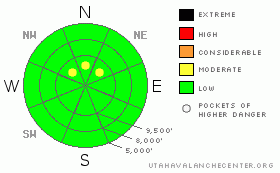
Danger by aspect and elevation on slopes approaching 35° or steeper.
(click HERE for tomorrow's danger rating)
|

Danger Rose Tutorial
|
There are pockets of MODERATE avalanche danger on steep upper elevation slopes facing northwest through northeast, above about 9,500’, where in isolated places a slide could still break near the ground, resulting in a rock bashing, damaging ride. It is also possible to trigger loose snow sluffs on steep slopes. If it snows more than a couple inches, or the winds blow where you are today, the new soft drifts and sluffs will become larger and be surprisingly sensitive. |
|
|
CURRENT CONDITIONS |

|
Under mostly cloudy skies, temperatures are once again in the single digits and teens this morning, and the northwesterly winds are averaging around 10 mph, with gusts to 20. Winds across the highest ridge lines are gusting into the 30s, putting the Wind Chill in exposed terrain around minus 15, so bundle up!
Friday night’s 1 to 3” inches of fluff actually created a few fun turns where it fell on the soft snow of wind sheltered, northerly facing slopes off ridge lines. Other than that, it’s now normal crust and rock fest. |
|
|
RECENT ACTIVITY |

|
The rapidly weakening surface snow allowed people to trigger some longer running shallow sluffs yesterday, with nothing else reported. |
|
|
THREAT #1 |

|
| WHERE |
PROBABILITY |
SIZE |
TREND |

|
|
|
|
| |
|
|
Over the next
24 hours.
|
|
|
The snow pack now has multiple weak, faceted layers top to bottom, especially on the northwest through easterly facing slopes. The super weak snow just below the wind crusts and at the surface is so in your face that it tends to distract you from the deeper weak layers of sugary snow near the ground. It is on these untrustworthy basal facets that you could trigger a slab today - on just a few slopes on very steep, upper elevation shady slopes, which would result in a painful, dangerous ride. |
|
|
THREAT #2 |

|
| WHERE |
PROBABILITY |
SIZE |
TREND |

|
|
|
|
| |
|
|
Over the next
24 hours.
|
|
|
The avalanche danger is generally Low, though the weakening surface snow sluffs easily. The addition of a few more inches of snow today, with a touch of wind, could create longer running, more sensitive sluffs and even a few easily triggered, very soft wind slabs. There are also a few old hard wind slabs beneath the fluff that could crack out.
Now none of these shallow, surface slides are going to bury you, but choice of terrain is still key – avoid slopes where a “knock you off balance” sluff or small wind drift could send you off a cliff or into trees and rocks. |
|
|
MOUNTAIN WEATHER |

|
Another weak disturbance with more cold air than moisture will reach northern Utah today, bringing the chance for a few inches of low density fluff today into tonight. High temperatures today will be in the mid teens at 8,000’ and near 10 at 10,000’. The northwesterly winds will slowly increase as the day goes on, into the 10 to 20 mph range, with gusts to 30. Along the highest ridges, average speeds could reach 30 mph, with gusts to 45.
Skies will clear late tonight, and we’ll wake up tomorrow morning with some of the coldest temperatures of the year – in the -5 to -10 degree range. Winds will remain from a northerly direction, and decrease slightly tomorrow. The weather forecast looks grim - dry all the way through next weekend, with a slow warming trend. |
|
|
GENERAL ANNOUNCEMENTS |
If you trigger an avalanche in the backcountry - especially if you are adjacent to a ski area – please call the following teams to alert them to the slide and whether anyone is missing or not. Rescue teams can be exposed to significant hazard when responding to avalanches, and do not want to do so when unneeded. Thanks.
Salt Lake – Alta Central (801-742-2033)
Ogden – Snowbasin Patrol Dispatch (801-620-1017)
Provo – Sundance Patrol Dispatch (801-223-4150)
Dawn Patrol Forecast Hotline, updated by 05:30: 888-999-4019 option 8.
Daily observations are frequently posted by 10 pm each evening.
Subscribe to the daily avalanche advisory e-mail click HERE.
UDOT canyon closures UDOT at (801) 975-4838
You have the opportunity to participate in the creation of our own community avalanche advisory by submitting avalanche and snow observations. You can also call us at 801-524-5304 or 800-662-4140, or email by clicking HERE
Donate to your favorite non-profit – The Friends of the Utah Avalanche Center. The UAC depends on contributions from users like you to support our work.
The information in this advisory is from the U.S. Forest Service, which is solely responsible for its content. This advisory describes general avalanche conditions and local variations always occur.
We will update this forecast tomorrow morning. Thanks for calling. |
|
|
This information does not apply to developed ski areas or highways where avalanche control is normally done. This advisory is from the U.S.D.A. Forest Service, which is solely responsible for its content. This advisory describes general avalanche conditions and local variations always occur. |
|
This advisory provided by the USDA Forest Service, in partnership with:
The Friends of the Utah Avalanche Center, Utah Division of State Parks and Recreation, Utah Division of Emergency Management, Salt Lake County, Salt Lake Unified Fire Authority and the friends of the La Sal Avalanche Center. See our Sponsors Page for a complete list. |

