SPECIAL ANNOUNCEMENT |
 |
We've got a couple of FREE avalanche education events coming up:
A Free Avalanche Awareness talk this Wednesday, November 30, at 9 pm at Milosport- 359 E University Pkwy, Orem, Utah 84058
A Free Women's Avalanche Beacon clinic, Dec 5th, 8:30-11:00 am, at the Albion Grill, Alta.
Click on Education in the main menu for a complete listing of avalanche classes and talks. |
|
|
BOTTOM LINE
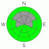
Danger by aspect and elevation on slopes approaching 35° or steeper.
(click HERE for tomorrow's danger rating)
|

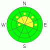
Danger Rose Tutorial
|
The avalanche danger is MODERATE on steep, northwest, north and northeasterly facing slopes above about 9,500’, where a person could trigger a 1 to 2’ deep avalanche. While the chance of triggering one of these deeper avalanches is decreasing, the consequences of getting caught remain the same - a terrible, rocky, pounding ride that might be unsurvivable. |
|
|
CURRENT CONDITIONS |

|
It’s another warm one - mid elevation temperatures have remained in the mid 30s to low 40’s all night, and only the highest elevations and low valley bottoms have temperatures at or below freezing this morning. The southwesterly winds are in the 10 to 15 mph range with gusts 25 to 35 mph.
The combination of wind and warmth over the past few days hasn’t left too much in the way of soft snow. But patches can be found off the ridge lines, on northerly facing, wind sheltered slopes, although the omnipresent rocks are making P-tex the stocking stuffer of the year. |
|
|
RECENT ACTIVITY |

|
The calendar might say December, but yesterday there were a few wet loose sluffs, both natural and skier released, on steep, southerly facing slopes. In addition, people found it possible to crack out a few of the thin wind slabs that were formed on Friday. There were no reports of deeper slides, though few people were teasing those slopes. |
|
|
THREAT #1 |

|
| WHERE |
PROBABILITY |
SIZE |
TREND |
|
|
|
|
| |
|
|
Over the next
24 hours.
|
|
|
The weak faceted snow near the ground remains a problem – in isolated places, on steep, upper elevation northwest, north and northeasterly facing slopes, a person could still trigger a dangerous slab avalanche breaking near the ground. Avoiding this terrain isn’t hard to do, and remains the best and safest alternative. |
|
|
THREAT #2 |

|
| WHERE |
PROBABILITY |
SIZE |
TREND |
|
|
|
|
| |
|
|
Over the next
24 hours.
|
|
|
The rest of the terrain has a mostly low avalanche danger, but stay on your toes any time you get on a slope approaching 35 degrees and steeper. There is always the usual cornucopia of details - thin, cracky wind slabs on a variety of aspects could pop out beneath you, or if the clouds are slow to arrive today, or thin enough, it may be possible to trigger a few more damp sluffs today. And above all, watch out for rocks, stumps and other barely hidden obstacles that could ruin the season. |
|
|
MOUNTAIN WEATHER |

|
It’s rather hard to get excited about the weather forecast these days – a dry cold front today will bring increasing clouds, a slight dip in temperatures, and perhaps a snowflake or two tonight. After another warm day Tuesday, a second cold front on Wednesday will bring another round of clouds, a few more snowflakes, colder air and annoyingly strong, easterly winds. By dawn Thursday, the easterly wind speeds could be in the 60 to 70 mph range across the high peaks. After that, it looks dry through the weekend… and through mid month, though it will possibly be punctuated with a few grazing, weak systems. |
|
|
GENERAL ANNOUNCEMENTS |
If you trigger an avalanche in the backcountry - especially if you are adjacent to a ski area – please call the following teams to alert them to the slide and whether anyone is missing or not. Rescue teams can be exposed to significant hazard when responding to avalanches, and do not want to do so when unneeded. Thanks.
Salt Lake – Alta Central (801-742-2033)
Ogden – Snowbasin Patrol Dispatch (801-620-1017)
Provo – Sundance Patrol Dispatch (801-223-4150)
Dawn Patrol Forecast Hotline, updated by 05:30: 888-999-4019 option 8.
Daily observations are frequently posted by 10 pm each evening.
Subscribe to the daily avalanche advisory e-mail click HERE.
UDOT canyon closures UDOT at (801) 975-4838
You have the opportunity to participate in the creation of our own community avalanche advisory by submitting avalanche and snow observations. You can also call us at 801-524-5304 or 800-662-4140, or email by clicking HERE
Donate to your favorite non-profit – The Friends of the Utah Avalanche Center. The UAC depends on contributions from users like you to support our work.
The information in this advisory is from the U.S. Forest Service, which is solely responsible for its content. This advisory describes general avalanche conditions and local variations always occur.
We will update this forecast tomorrow morning. Thanks for calling. |
|
|
This information does not apply to developed ski areas or highways where avalanche control is normally done. This advisory is from the U.S.D.A. Forest Service, which is solely responsible for its content. This advisory describes general avalanche conditions and local variations always occur. |
|
This advisory provided by the USDA Forest Service, in partnership with:
The Friends of the Utah Avalanche Center, Utah Division of State Parks and Recreation, Utah Division of Emergency Management, Salt Lake County, Salt Lake Unified Fire Authority and the friends of the La Sal Avalanche Center. See our Sponsors Page for a complete list. |
