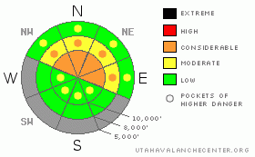
BOTTOM LINE
Danger by aspect and elevation on slopes approaching 35° or steeper.
(click HERE for tomorrow's danger rating)
|
Danger Rose Tutorial
|
The avalanche danger is a solid CONSIDERABLE in terrain above 9500 on northwest through east facing slopes. It could easily go to HIGH danger in the Cottonwoods if we see heavy snowfall this morning. Make no doubt that conditions are ripe for someone to get caught in an avalanche. The danger is significantly lower in areas that don’t have old snow from October which include all aspects below 9500 feet and all south facing slopes. |
|
|
CURRENT CONDITIONS |

|
This little “one-two” punch is giving us some much needed new snow. As of 7am this morning, snow totals since Saturday morning are around a foot or better of higher density snow. Densities were measured in the 10 to 14% range Saturday and are a bit lower this morning. Southwest winds were screaming pretty good prior to the cold front on Saturday with gusts in the 70s along the most exposed ridges. They slowed with the frontal passage and remain in the 10 to 20mph range gusting into the 30s along the ridges. The cold front moved through mid day on Saturday but since temperatures have climbed again and are fairly mild in the mid to upper 20s. Only the highest elevations are in the low 20s. It's been snowing since about 3am this morning. |
|
|
RECENT ACTIVITY |

|
The combination of higher density snow and gusty wind were the perfect combo for slab formation over our preexisting weak early season snow. Collapsing has been a consistent comment in backcountry observations all week and continued yesterday. Two human triggered slab avalanches were also reported from Snowbird (which is not yet open for the season) where a backcountry party was experiencing collapsing and were able to remotely trigger avalanches from a safe location. The slabs were about a foot deep and up to 100 feet wide. DETAILS |
|
|
THREAT #1 |

|
| WHERE |
PROBABILITY |
SIZE |
TREND |
|
|
|
|
| |
|
|
Over the next
6 hours.
|
|
|
In my mind, there are two parts to our current avalanche concern; an easy part and a hard part.
The easy part is identifying the problem which consists of snow from October that has become weak with time and is now getting overloaded with new dense snow. Areas that held onto snow from October are in terrain above around 9500 feet that face northwest through east. If you dig down in these areas it is easy to find sugary (faceted) weak snow near the ground often associated with a crust. Next only to actual avalanche activity, collapsing is the biggest sign of an avalanche prone snow structure and we’ve seen both avalanches and collapsing over the last week.
The hard part will be to curb our enthusiasm for early season powder. We want to go where the snow coverage is the best but these are the most likely spots to take a ride in an avalanche. The avalanches won’t be exceptionally large. Class 2s for the most part which are enough to be lethal.
So, the avalanche conditions are not tricky. We know what they are and where they are. It’s obvious to the trained eye. The tricky part is controlling our lust. Lust for the legendary Utah powder which we all desire. |
|
|
MOUNTAIN WEATHER |

|
The current storm should continue to produce snow through this morning and taper off afternoon. We could see an additional 3 to 7 inches of snow this morning adding .25 to .4 inches of water weight to the weak snowpack. The flow is switching more northwest which often can favor the Cottonwoods and produce more snow than expected. Watch for avalanche conditions to spike if this happens. Temperatures will be in the mid 20s and winds from the northwest in the moderate speed category. |
|
|
This information does not apply to developed ski areas or highways where avalanche control is normally done. This advisory is from the U.S.D.A. Forest Service, which is solely responsible for its content. This advisory describes general avalanche conditions and local variations always occur. |
|
This advisory provided by the USDA Forest Service, in partnership with:
The Friends of the Utah Avalanche Center, Utah Division of State Parks and Recreation, Utah Division of Emergency Management, Salt Lake County, Salt Lake Unified Fire Authority and the friends of the La Sal Avalanche Center. See our Sponsors Page for a complete list. |
