SPECIAL ANNOUNCEMENT |
 |
EXPECT AVALANCHE DANGER TO RISE THIS WEEKEND.
NEXT ADVISORY UPDATES - Next advisory on Saturday night or Sunday morning. |
|
|
BOTTOM LINE
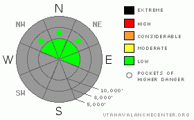
Danger by aspect and elevation on slopes approaching 35° or steeper.
(click HERE for tomorrow's danger rating)
|
Danger Rose Tutorial
|
Increasing avalanche danger this weekend.
The avalanche danger is generally LOW (Level 1) but the avalanche danger should rise to MODERATE (Level 2) or possibly CONSIDERABLE (Level 3) this weekend as the storm overloads the very weak snow on the ground right now. The danger this weekend will be on the north through east facing slopes above about 10,000', especially on slopes with recent wind deposits. The danger on the south facing slopes should remain LOW. |
|
|
CURRENT CONDITIONS |

|
There is very little snow on the south and west facing slopes but the north and east facing slopes above about 10,000' have about a foot of snow. Above 10,500' in Little Cottonwood Canyon many slopes have about a foot and a half with more in wind drifted areas. Even the snowy slopes remain quite rocky and especially in Big Cottonwood Canyon, traveling on foot is still probably the best way to get around. You can still drive over Guardsman's Pass between Big Cottonwood and Park City. Brighton and Solitude are open on artificial snow. Snowbird and Alta are expected to open the weekend of the 19th.
The clear skies continue to melt snow off the south facing slopes and make the snow surface weaker and weaker on the shady, north through east facing slopes. |
|
|
RECENT ACTIVITY |

|
No avalanches have been reported in a couple days but people continue to experience collapsing of the snowpack onto a buried layer of faceted snow about 6 inches to a foot deep. |
|
|
THREAT #1 |

|
| WHERE |
PROBABILITY |
SIZE |
TREND |
|
|
|
|
| |
|
|
Over the next
24 hours.
|
|
|
Although the snow on the ground is mostly stable, there may be a few areas where you could still trigger an avalanche, mostly above about 10,000' on north through east facing slopes.
The main concern is the storm expected to arrive Saturday night, which looks like it will give us another foot of new snow--possibly more in favored areas. The first part of the storm looks like it will arrive with a fairly strong southwesterly wind, which will drift snow onto the weak and fragile north through east facing slopes. Expect avalanche danger to rise this weekend. The snow on the ground right now is quite weak. The snow surface has become faceted and of more concern, I have found fairly widespread areas of buried faceted snow about 6 inches to a foot deep on most of the upper elevation north through east facing slopes. Expect the storm this weekend to overload many of these slopes, especially on slopes with recent deposits of wind drifted snow.
See my snow profile at: http://utahavalanchecenter.org/obs_snow_profile_guardsmans_pass_11102011
and check out other current observations at: http://utahavalanchecenter.org/services |
|
|
MOUNTAIN WEATHER |

|
We should have another warm, day on Friday but with increasing clouds and stronger southwest winds. Saturday, the snow should arrive in two waves, one Saturday mid day through night and the other later on Sunday. Be sure to monitor the weather conditions closely since we will not update this advisory on Friday. We expect about a foot of new snow with wind and there may be more snow in favored areas such as Little Cottonwood Canyon.
For weather information check out the NWS Snow and Avalanche page at http://www.wrh.noaa.gov/slc/snow/ |
|
|
GENERAL ANNOUNCEMENTS |
If you trigger an avalanche in the backcountry - especially if you are adjacent to a ski area – please call the following teams to alert them to the slide and whether anyone is missing or not. Rescue teams can be exposed to significant hazard when responding to avalanches, and do not want to do so when unneeded. Thanks.
Salt Lake – Alta Central (801-742-2033)
Subscribe to the daily avalanche advisory e-mail click HERE.
UDOT canyon closures UDOT at (801) 975-4838
You have the opportunity to participate in the creation of our own community avalanche advisory by submitting avalanche and snow observations. You can also call us at 801-524-5304 or 800-662-4140, or email by clicking HERE
Donate to your favorite non-profit – The Friends of the Utah Avalanche Center. The UAC depends on contributions from users like you to support our work.
The information in this advisory is from the U.S. Forest Service, which is solely responsible for its content. This advisory describes general avalanche conditions and local variations always occur.
We will update this forecast by Saturday morning. Thanks for calling. |
|
|
This information does not apply to developed ski areas or highways where avalanche control is normally done. This advisory is from the U.S.D.A. Forest Service, which is solely responsible for its content. This advisory describes general avalanche conditions and local variations always occur. |
|
This advisory provided by the USDA Forest Service, in partnership with:
The Friends of the Utah Avalanche Center, Utah Division of State Parks and Recreation, Utah Division of Emergency Management, Salt Lake County, Salt Lake Unified Fire Authority and the friends of the La Sal Avalanche Center. See our Sponsors Page for a complete list. |
