SPECIAL ANNOUNCEMENT |
 |
NEXT ADVISORY UPDATES - Friday through the weekend.
On Wednesday UDOT plans to fire targets in mid-Lt Cottonwood, and on Thursday above the Town of Alta and the Snowbird Village. This will require going to Inter-Lodge Travel Restrictions at Alta and Snowbird, meaning EVERYONE must be indoors while we are firing, including skiers. UDOTwants to inform prospective early morning skiers that they will not be allowed to be outside anywhere at Alta or Snowbird on Thursday morning from 6:30 a.m. to around 8:30 a.m. |
|
|
BOTTOM LINE
Danger by aspect and elevation on slopes approaching 35° or steeper.
(click HERE for tomorrow's danger rating)
|
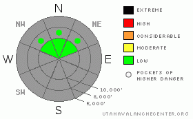
Danger Rose Tutorial
|
The avalanche danger is generally LOW. It will be possible to trigger sluffs on steep, northwest through northeasterly facing slopes where old snow from earlier storms is covering the ground features, forming a smooth base. If winds increase and drift the snow, slab avalanches will become possible in steep, wind drifted terrain.
If it’s your 1st time out for the season, start thinking avalanches, and a beacon with fresh batteries and shovel should be part of your standard gear. |
|
|
CURRENT CONDITIONS |

|
Cold temperatures and a few inches of snow are all that occurred on Monday, with light winds from the northwest.
I have to admit I still haven’t looked at my bases after the weekend's foray… There are definitely some nice powder turns to be had where there is an old base from earlier storms on the upper elevation northerly facing slopes and on packed runs at the unopened resorts, but else where, use care. Most other slopes are just new snow on bare ground, so the greatest hazard out there is hitting rocks or logs with season ending speed. |
|
|
RECENT ACTIVITY |

|
Avalanche wise, a few new snow sluffs were triggered on steep, northerly facing slopes over the weekend, where there was preexisting old snow to act as a bed surface, but not much more. |
|
|
THREAT #1 |

|
| WHERE |
PROBABILITY |
SIZE |
TREND |
|
|
|
|
| |
|
|
Over the next
12 hours.
|
|
|
Other than a few sluffs, the avalanche world will be fairly quiet out there this week, until it either snows or the winds blow. Snowpack wise, we're in the unenviable position of a shallow snow pack with long nights and cold temperatures. If you're out and about, keep a close eye on the weakening snow, especially the low density surface snow. |
|
|
MOUNTAIN WEATHER |

|
Decreasing moisture will bring an end to the snow showers tonight. A weak disturbance will move through the state Tuesday afternoon, increasing cloud cover and bringing the possibility for a few snow flurries Tuesday night. High pressure will build into the state Wednesday through Friday, bringing gradually warming temperatures. At 8500’, low temperatures will warm into the 20s and highs into the 40s. The next storm system is expected over the weekend, but unfortunately looks weak, splitting and sending most of the energy either south or north of the Wasatch.
For weather information check out the NWS Snow and Avalanche page at http://www.wrh.noaa.gov/slc/snow/ |
|
|
GENERAL ANNOUNCEMENTS |
We'll update this forecast later this week as conditions change. If you're getting out, please send us an observation or email. Thanks! |
|
|
This information does not apply to developed ski areas or highways where avalanche control is normally done. This advisory is from the U.S.D.A. Forest Service, which is solely responsible for its content. This advisory describes general avalanche conditions and local variations always occur. |
|
This advisory provided by the USDA Forest Service, in partnership with:
The Friends of the Utah Avalanche Center, Utah Division of State Parks and Recreation, Utah Division of Emergency Management, Salt Lake County, Salt Lake Unified Fire Authority and the friends of the La Sal Avalanche Center. See our Sponsors Page for a complete list. |
