SPECIAL ANNOUNCEMENT |
 |
We hope you can join us today for the 4th annual Utah Snow and Avalanche Workshop at the Depot from 1 to 5 pm on Saturday, November 5.
Modeled after the International Snow Science Workshop, this event brings together avalanche professionals, experienced backcountry and sidecountry skiers and snowboarders, sledders, and those new to the game to take a closer look at the underbelly of the avalanche dragon. Join us to geek out on snow science, explore how we make high-risk decisions, and recreate and learn from some serious accidents from last year. This is great way to learn from the best our community has to offer and to hang out with a bunch of like-minded folks.
Admission is $25 for tickets purchased in advance online and $30 at the door if there are any seats left. Details, agenda, and ticket purchase info at http://utahavalanchecenter.org/usaw11-5-2011 |
|
|
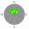
BOTTOM LINE
Danger by aspect and elevation on slopes approaching 35° or steeper.
(click HERE for tomorrow's danger rating)
|
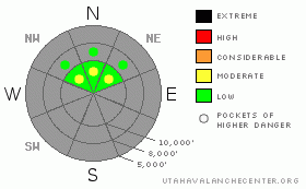
Danger Rose Tutorial
|
The avalanche danger has risen to MODERATE on steep, northwest through northeasterly facing slopes where old snow from earlier storms is covering the ground features like rocks. Basically, if its steep, smooth and filled in, it could slide. Most of these shallow new snow sluffs and slabs avalanches will be in the 6 to 10 inch range, which is large enough to knock you off your feet, gather speed and carry you down slope for a rocky ride.
Even if it’s your 1st time out for the season, start thinking avalanches, and a beacon with fresh batteries and shovel should be part of your standard gear. |
|
|
CURRENT CONDITIONS |

|
The splitting storm system arrived last night, and as of 5 am this morning, light snow is still falling, and snow totals are in the disappointing 2 to 6” range in the Wasatch mountains, from Ogden south through Provo. The northwesterly winds have decreased dramatically from yesterday, and are light, generally averaging less than 15 mph, with gusts to around 20 mph. Temperatures are still dropping, currently in the low twenties at 8,000’ to mid teens at 10,000’. |
|
|
THREAT #1 |

|
| WHERE |
PROBABILITY |
SIZE |
TREND |
|
|
|
|
| |
|
|
Over the next
12 hours.
|
|
|
The new snow is landing everything from dry ground and rocks to patches of hard old snow from earlier storms. We’ll all be drawn to slopes with the best coverage – smooth, filled in shady upper elevation northerly facing slopes. Here, the old snow surface was a mix of weak, sugary facets and old crusts, and the new snow will not bond well. It will be possible to trigger new snow sluffs and perhaps a few soft slabs on steep slopes where the preexisting snow covered all the ground features, like rocks. With facets as the week layer, the new snow slides could be fairly snappy, and even shallow sluffs could be surprisingly fast moving on the slick bed surfaces. These new snow slide will be limited in depth, but not speed. In early season, almost any slide or ride will be rough, have you hitting shallowly buried rocks. So use careful slope cuts on short, steep test slopes to help determine how sensitive the new snow is, always making sure no one is below you. |
|
|
MOUNTAIN WEATHER |

|
Light snow will continue through around noon, hopefully adding another 3 to 6” to the totals. Temperatures will remain in the teens today, and the winds light, averaging only 10 to 20 mph, as they gradually shift from the northwest to west. A second storm will once again split, with most of it’s energy going south, but the northern mountains do have another chance for a few inches of snow Sunday into Monday, followed by dry and gradually warming conditions through mid week. |
|
|
This information does not apply to developed ski areas or highways where avalanche control is normally done. This advisory is from the U.S.D.A. Forest Service, which is solely responsible for its content. This advisory describes general avalanche conditions and local variations always occur. |
|
This advisory provided by the USDA Forest Service, in partnership with:
The Friends of the Utah Avalanche Center, Utah Division of State Parks and Recreation, Utah Division of Emergency Management, Salt Lake County, Salt Lake Unified Fire Authority and the friends of the La Sal Avalanche Center. See our Sponsors Page for a complete list. |
