Salt Lake Avalanche Advisory

Forecaster: Bruce Tremper

SPECIAL ANNOUNCEMENT

We will end our avalanche advisories after this weekend but we will continue to post observations that you fill out so that everyone can share avalanche information.

We were able to extended our forecast season by two weeks because of a generous donation by Backcountry.com to our partners the Friends of the Utah Avalanche Center. Thank You!!


BOTTOM LINE

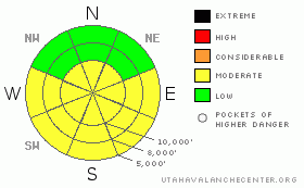
Danger by aspect and elevation on slopes approaching 35° or steeper.
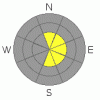
(click HERE for tomorrow's danger rating)


Danger Rose Tutorial

The avalanche danger is mostly MODERATE (Level 2) for a variety of avalanche problems today including unusually huge and sensitive cornices, wet avalanches on steep sun exposed slopes and lingering wind slabs along the upper elevation ridges, especially on north through east facing slopes.


CURRENT CONDITIONS

Most of the sun exposed slopes are crusted but there is some soft, settled powder above 10.000' on north facing.


RECENT ACTIVITY

Wow, what an active day. As forecast, there were many lingering wind slabs just waiting for a trigger. There were at least a dozen human triggered avalanches in the backcountry of the Salt Lake area mountains with many dozens of natural wind slabs. You can read many of the details in Current Conditions.

Probably the most interesting included one large, natural, cornice-triggered avalanche off Gobbler’s Knob into Alexander basin. Another huge unintentionally-triggered cornice on Gobbler’s that dropped a person onto the slope below, Yet another unintentionally-triggered cornice, which triggered a large avalanche on Cardiac Ridge, a skier triggered wind slab on Cardiac ridge, one in Days fork, Silver Fork and the usual rash of slides in the Brighton periphery, a wet avalanche on Murdock Peak. And there must have been many more that I did not hear about.

As near as I can tell, there were no injuries or worse.

The culprit was the very strong winds on Thursday afternoon from passing thunderstorms and continued strong winds Thursday night. The resulting deposits of wind drifted snow (wind slabs) rested on top of very light stellar snow right above the old snow surface. The slabs were very sensitive in the morning but settled out quite a bit by afternoon.

If that’s not enough, there were the usual hoards skiing and boarding the south face of Superior and as the sun warmed up the snow there was widespread, shallow, damp sluffs and slabs that cleaned out much of the upper mountain and ran to the transition.

The good visibility yesterday revealed several large natural avalanches, one cornice-triggered slide in Hogum Fork (Dresden Face) 2-4' x 200', one cornice-triggered slide on the Coalpit Face of the same size that stepped down to about 10' deep lower on the slope. Some of these may have occurred before yesterday.


THREAT #1

WHERE PROBABILITY SIZE TREND
      Over the next 24 hours.

Cornices are huge and several have dropped off on their own, triggering larger avalanches beneath them and a couple we heard about yesterday were triggered by people, all breaking much farther back than expected. Don't mess with these monsters. Never approach a drop off along a ridge and give them twice as wide a berth as usual.


THREAT #2

WHERE PROBABILITY SIZE TREND
      Over the next 18 hours.

Temperatures will be warmer today but balanced by more clouds. Watch for greenhousing of the strong spring sun. As usual, stay off of steep slopes when they are getting wet.


THREAT #3

WHERE PROBABILITY SIZE TREND
      Over the next 24 hours.

Finally, you might find a few lingering wind slabs along the upper elevation ridges from the strong west winds we had on Thursday and Thursday night.


MOUNTAIN WEATHER

We should have mostly cloudy skies today with a few light snow showers with no significant accumulation. Winds should remain light and ridge top temperatures should be near freezing and 8,000' temperatures should be around 40 degrees.

We have another weak pulse again tomorrow but the strongest pulse will arrive around Monday night, which could give us 8 inches of snow.

See the Cottonwood Canyons forecast.


GENERAL ANNOUNCEMENTS

GENERAL ANNOUNCEMENTS

If you trigger an avalanche in the backcountry - especially if you are adjacent to a ski area – please call the following teams to alert them to the slide and whether anyone is missing or not. Rescue teams can be exposed to significant hazard when responding to avalanches, and do not want to do so when unneeded. Thanks.

Salt Lake – Alta Central (801-742-2033)

Ogden – Snowbasin Patrol Dispatch (801-620-1017)

Provo – Sundance Patrol Dispatch (801-223-4150)

Dawn Patrol Forecast Hotline, updated by 05:30: 888-999-4019 option 8.

Daily observations are frequently posted by 10 pm each evening.

Subscribe to the daily avalanche advisory e-mail click HERE.

UDOT canyon closures UDOT at (801) 975-4838

You have the opportunity to participate in the creation of our own community avalanche advisory by submitting avalanche and snow observations. You can also call us at 801-524-5304 or 800-662-4140, or email by clicking HERE

Donate to your favorite non-profit – The Friends of the Utah Avalanche Center. The UAC depends on contributions from users like you to support our work.

The information in this advisory is from the U.S. Forest Service, which is solely responsible for its content. This advisory describes general avalanche conditions and local variations always occur.

We will update this forecast either Friday night or Saturday morning. Thanks for calling.


This information does not apply to developed ski areas or highways where avalanche control is normally done.  This advisory is from the U.S.D.A. Forest Service, which is solely responsible for its content. This advisory describes general avalanche conditions and local variations always occur.


This advisory provided by the USDA Forest Service, in partnership with:

The Friends of the Utah Avalanche Center, Utah Division of State Parks and Recreation, Utah Division of Emergency Management, Salt Lake County, Salt Lake Unified Fire Authority and the friends of the La Sal Avalanche Center. See our Sponsors Page for a complete list.