SPECIAL ANNOUNCEMENT |
 |
Through a generous donation by Backcountry.com to our partners the Friends of the Utah Avalanche Center we will continue forecasting until April 24th. I will issue a combination of early morning weekend forecasts and mid week afternoon updates, with weekend only updates for the Logan and Uintas area mountains. Thank You!! |
|
|
BOTTOM LINE
Danger by aspect and elevation on slopes approaching 35° or steeper.
(click HERE for tomorrow's danger rating)
|
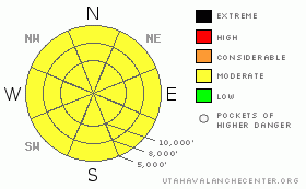
Danger Rose Tutorial
|
The avalanche danger is mostly MODERATE (Level 2) for a variety of different avalanche problems, wet sluff at low and mid elevations, lingering wind slabs at upper elevations, sensitive, large cornices and lingering deep slabs. |
|
|
CURRENT CONDITIONS |

|
With clear skies overnight and cooler temperatures, the snow has settled and crusted over. Temperatures are 18 degrees at 9,000' and 14 degrees at 11,000' with light winds. Snow yesterday ranged from creamy, wet snow to breakable crust. Most should have various kinds of crusts this morning. |
|
|
RECENT ACTIVITY |

|
There was a couple close calls yesterday in the backcountry, plus one large deep slab. All details are posted in Current Conditions.
A skier was caught, carried and tweaked a knee on Tuscarora (between Alta and Brighton), Another skier broke a cornice along Honycomb Ridge (above Solitude) and barely escaped going down with it. Finally, there was a frightening, deep-slab, natural release in Mill B South (Lake Blanche area) that broke out perhaps 10 feet deep and 200' wide. There are great photos on the web. |
|
|
THREAT #1 |

|
| WHERE |
PROBABILITY |
SIZE |
TREND |

|
|
|
|
| |
|
|
Over the next
24 hours.
|
|
|
Most of the instabilities from yesterday should be settled out by today. But with the complex nature of these wet spring conditions, it's hard to pin down much of a pattern so I have colored in the rose all yellow (Moderate). And I have lumped them all together here.
You may be able to find some wet sluffs at low to mid elevations on all aspects. There may be some lingering wind slabs at high elevations. Cornices remain sensitive and large. And there is the deep slab problem.....
As for those pesky and scary deep slabs: Everyone has been asking if the stout rain crust formed on Martin Luther King weekend in January (the famous MLK rain crust) is going to produce wet slabs this spring. I keep answering I have no idea. This is the thickest, stoutest rain crust in perhaps the past 40 years, so we have no experience with how it will behave when the water starts percolating down to it. In theory, the water should pool up above the crust and weaken the snow. But we notice many areas with percolation columns below that crust, so it was able to drain in many areas when it formed. So what will happen this spring, I have no idea.
We got a good glimpse yesterday thanks to the great photos by Kip Conklin. It was deja vu all over again--steep, unsupported, rocky slope, east facing--just like earlier in the winter and it appeared from the photos to to release to the shiny rain crust. So that is likely a sign of things to come as soon as the weather finally figures out what time of year it is and seriously warms up. Thankfully, by the time that will likely happen, we will be done forecasting and won't have to worry about it. But you will. |
|
|
MOUNTAIN WEATHER |

|
It's yet another calm before yet another storm. With a short-lived, high pressure ridge building in, temperatures will warm rapidly today and the rain-snow line should rise to nearly 10,000' once again. We should have relatively clear skies this morning but clouds will come in this afternoon and we will see light rain showers with light snow above 9,000' this afternoon. The strongest precipitation intensity expected on Thursday afternoon.
Weather should remain unsettled for several more days. Same as it ever was....
Graph of mountain weather. |
|
|
GENERAL ANNOUNCEMENTS |
GENERAL ANNOUNCEMENTS
If you trigger an avalanche in the backcountry - especially if you are adjacent to a ski area – please call the following teams to alert them to the slide and whether anyone is missing or not. Rescue teams can be exposed to significant hazard when responding to avalanches, and do not want to do so when unneeded. Thanks.
Salt Lake – Alta Central (801-742-2033)
Ogden – Snowbasin Patrol Dispatch (801-620-1017)
Provo – Sundance Patrol Dispatch (801-223-4150)
Dawn Patrol Forecast Hotline, updated by 05:30: 888-999-4019 option 8.
Daily observations are frequently posted by 10 pm each evening.
Subscribe to the daily avalanche advisory e-mail click HERE.
UDOT canyon closures UDOT at (801) 975-4838
You have the opportunity to participate in the creation of our own community avalanche advisory by submitting avalanche and snow observations. You can also call us at 801-524-5304 or 800-662-4140, or email by clicking HERE
Donate to your favorite non-profit – The Friends of the Utah Avalanche Center. The UAC depends on contributions from users like you to support our work.
The information in this advisory is from the U.S. Forest Service, which is solely responsible for its content. This advisory describes general avalanche conditions and local variations always occur.
We will update this forecast tomorrow morning. Thanks for calling. |
|
|
This information does not apply to developed ski areas or highways where avalanche control is normally done. This advisory is from the U.S.D.A. Forest Service, which is solely responsible for its content. This advisory describes general avalanche conditions and local variations always occur. |
|
This advisory provided by the USDA Forest Service, in partnership with:
The Friends of the Utah Avalanche Center, Utah Division of State Parks and Recreation, Utah Division of Emergency Management, Salt Lake County, Salt Lake Unified Fire Authority and the friends of the La Sal Avalanche Center. See our Sponsors Page for a complete list. |
