SPECIAL ANNOUNCEMENT |
 |
Since winter has refused to realize that it's spring, we will resume our early morning avalanche advisories through the weekend. |
|
|
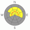
BOTTOM LINE
Danger by aspect and elevation on slopes approaching 35° or steeper.
(click HERE for tomorrow's danger rating)
|
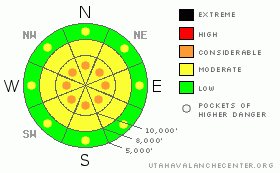
Danger Rose Tutorial
|
The avalanche danger is MODERATE (L2) with Pockets of CONSIDERABLE (L3) on mid to upper elevation slopes for human triggered new snow slides and for triggering a fresh wind drift, on slopes approaching 35 degrees and steeper. The wind drifts will be most widespread on northwest through northeasterly facing slopes.
It is a MODERATE (L2) avalanche danger on upper elevation slopes for the possibility of a new snow avalanche stepping down to a deeper weak layer. It would most likely be on an upper elevation, heavily wind drifted, steep northwest through northeasterly facing slope. |
|
|
CURRENT CONDITIONS |

|
The Ogden area mountains have received the most snow so far, with up to 16” of snow on Ben Lomond Peak, containing 2 inches of water. Elsewhere, the southerly flow is spreading the snow very evenly, and most locations in the Salt Lake, Park City and Provo area mountains are pushing a foot or more of snow as of 6 am, and the snow is still falling. Winds have decreased dramatically from yesterday, and peaks favored by southerly flow are now in the 20 to 30 mph range, with gusts to 40. Elsewhere, speeds are a very civilized 10 to 20 mph, gusting to 30. 10,000’ foot temperatures are in the low 20s. |
|
|
RECENT ACTIVITY |

|
Yesterday, there were reports of sensitive wind drifts in upper elevation terrain for the Ogden area mountains, which received early snow. |
|
|
THREAT #1 |

|
| WHERE |
PROBABILITY |
SIZE |
TREND |

|
|
|
|
| |
|
|
Over the next
24 hours.
|
|
|
The storm snow is stacking up, and the new snow is generally “right side up” – becoming dryer and lighter as the storm progressed, but, just the sheer quantity will make the snow sensitive steep slopes, especially early in the day or during any periods of intense snowfall. Sluffs and soft slabs will be easy to trigger on steep slopes, and careful slope cuts will be a good tool for experienced users.
Poor bonding of the new snow to the slick ice crust beneath is possible on some of the higher elevation slopes. There should be better bonding of the new snow to the old snow surface at the mid and lower elevations.
Just a glimpse of the intense spring sun or a thinning of clouds, which is possible this afternoon, and the snow at the low and mid elevations will heat and become sensitive, and damp loose sluffs will become easy to trigger on steep slopes. |
|
|
THREAT #2 |

|
| WHERE |
PROBABILITY |
SIZE |
TREND |
|
|
|
|
| |
|
|
Over the next
24 hours.
|
|
|
The strong, southerly winds which have been blowing since yesterday, have only decreased in the past few hours. So hidden beneath the new snow are drifts, which will be sensitive on steep slopes. Avoid steep, wind drifted slopes, which will be most widespread on northwesterly through northeasterly facing slopes, and new cornices that may be sensitive. |
|
|
THREAT #3 |

|
| WHERE |
PROBABILITY |
SIZE |
TREND |

|
|
|
|
| |
|
|
Over the next
24 hours.
|
|
|
Two mid week warm periods between storms created dry snow/ice crust sandwiches in the upper snow pack at the higher elevations. There is the potential for slides to break out beneath these thin, weak crusts, resulting in a wider or even remotely triggered slide. It will be easy to do multiple pole plants or dig down with your hand to investigate the upper pack layering where you are traveling. There is also an isolated chance today of triggering an even deeper slide down to a January weak layer, which will gradually increase over the next several days as the snow adds up. |
|
|
MOUNTAIN WEATHER |

|
A cold pacific storm system will continue to bring snow to the Wasatch mountains on a southerly flow will through the day. Moderate snow fall rates of over an inch an hour are possible at times, and an additional 5 to 9” of snow is expected by the end of the day. Temperatures won’t warm much today – remaining in the upper twenties at 8,000’ and in the upper teens at 10,000’. The southerly winds will continue to decrease, with averages of 5 to 55 mph and gusts to 25 this afternoon. The highest peaks could still average 30 mph with gusts to 50. More snow is expected tonight and Saturday. A break in the snow is expected Sunday into early Monday, before another cold winter storm bring snow to the mountains of northern Utah late Monday through Wednesday. |
|
|
GENERAL ANNOUNCEMENTS |
GENERAL ANNOUNCEMENTS
If you trigger an avalanche in the backcountry - especially if you are adjacent to a ski area – please call the following teams to alert them to the slide and whether anyone is missing or not. Rescue teams can be exposed to significant hazard when responding to avalanches, and do not want to do so when unneeded. Thanks.
Salt Lake – Alta Central (801-742-2033)
Ogden – Snowbasin Patrol Dispatch (801-620-1017)
Provo – Sundance Patrol Dispatch (801-223-4150)
Dawn Patrol Forecast Hotline, updated by 05:30: 888-999-4019 option 8.
Daily observations are frequently posted by 10 pm each evening.
Subscribe to the daily avalanche advisory e-mail click HERE.
UDOT canyon closures UDOT at (801) 975-4838
You have the opportunity to participate in the creation of our own community avalanche advisory by submitting avalanche and snow observations. You can also call us at 801-524-5304 or 800-662-4140, or email by clicking HERE
Donate to your favorite non-profit – The Friends of the Utah Avalanche Center. The UAC depends on contributions from users like you to support our work.
The information in this advisory is from the U.S. Forest Service, which is solely responsible for its content. This advisory describes general avalanche conditions and local variations always occur.
We will update this forecast tomorrow morning. Thanks for calling. |
|
|
This information does not apply to developed ski areas or highways where avalanche control is normally done. This advisory is from the U.S.D.A. Forest Service, which is solely responsible for its content. This advisory describes general avalanche conditions and local variations always occur. |
|
This advisory provided by the USDA Forest Service, in partnership with:
The Friends of the Utah Avalanche Center, Utah Division of State Parks and Recreation, Utah Division of Emergency Management, Salt Lake County, Salt Lake Unified Fire Authority and the friends of the La Sal Avalanche Center. See our Sponsors Page for a complete list. |
