SPECIAL ANNOUNCEMENT |
 |
UAC CLOSING AFTER THIS WEEKEND: Sunday will be our last day of issuing advisories for the season as our piggy bank has run dry.
We will continue to accept and publish observations from backcountry users who submit them. You can find them in the Current Conditions off the main menu.
We would like to thank everyone who contributed to your community avalanche center. We are a Forest Service program but over 3/4 of the funding comes from other partners. This includes: all of your donations through Friends of the Utah Avalanche Center, Utah Division of State Parks and Recreation, Utah Public Safety, Salt Lake County, Black Diamond, Backcountry.com, all the ski areas that donated lift tickets, Ski Utah, Unified Fire Authority and the various shops that donate snowmobiles and other equipment such as Polaris/Tri-City Performance, Weller's Recreation/Ski Doo and Arctic Cat/Big Pine Sports, Recco, Wasatch Backcountry Rescue, Back Country Access and ABS. Whew! Forgive me for anyone I have forgotton. As you can see, we have lots of support.
We are still collecting feedback from you with our 10 question survey. Please feel free to let us know you’re thoughts. CLICK FOR SURVEY |
|
|
BOTTOM LINE
Danger by aspect and elevation on slopes approaching 35° or steeper.
(click HERE for tomorrow's danger rating)
|
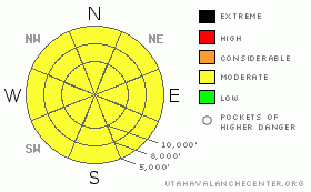
Danger Rose Tutorial
|
The avalanche danger is MODERATE (L2) for human triggered wet loose sluffs on steep slopes of all aspects and elevations, and naturals will be possible if you are in an area that receives a lot of sun with no wind this morning or rain late this afternoon. Cornices remain a significant concern for those travelling the ridgelines. Deep Slab releases are unlikely, but large triggers such as cornice drops or wet avalanches could release one of these potentially unsurvivable slides.
Saturday night and Sunday: a potent cold front will bring periods of heavy snow with strong winds, creating an increasing avalanche danger for New Snow avalanches and Wind Slabs, with human triggered and natural avalanches possible through the night and early tomorrow morning. |
|
|
CURRENT CONDITIONS |

|
Under clear skies, it’s another warm one – 9 to 10,000’ temperatures are in the low to mid 40s this morning. The winds are from the southwest, and have increase in the last few hours. Speeds of 15 to 25 mph, with gusts in the 30’s, are the average, with the higher peaks averaging in the 25 to 35 mph range, gusting in the 50s and 60s.
Yesterday was one of those days where it was easier to go uphill than down, unless you managed to catch the supportable, corn like crusts in the morning at the mid elevations, or were on snowshoes or a snowmobile. This morning, the overnight clear skies and winds will have allowed for a thin, short lived corn-like refreeze on some slopes. |
|
|
RECENT ACTIVITY |

|
Yesterday, most of the snow seemed content to age in place, with smaller, natural wet loose sluffs the main activity. A few larger sluffs were triggered with explosives. In the warmer clime of the Ogden area mountains, there was continued widespread wet avalanche activity, that included more serious wet slabs, mostly on east, south and west facing slopes. |
|
|
THREAT #1 |

|
| WHERE |
PROBABILITY |
SIZE |
TREND |

|
|
|
|
| |
|
|
Over the next
12 hours.
|
|
|
Today will be a balancing act between the sun, wind, clouds and temperatures. Wet sluffs and slabs are the main concern on all aspects and elevations. The prolonged above freezing temperatures are the obvious problem, but luckily they will be counter balanced by strong winds and increasing clouds today, which will help to cool the snow. However, the snow is so wet and soggy that human triggered sluffs will be possible on steep slopes. Once these sluffs get going, they can pile up deep, cement like debris, and possibly trigger a Deep Slab avalanche. Glide cracks may release today, as well as snow sliding off roofs.
And just to keep things exciting, a period of heavy rain is possible at or below 9,000’ feet late this afternoon or early tonight. If this happens where you are, the danger of wet avalanche will increase even more. |
|
|
THREAT #2 |

|
| WHERE |
PROBABILITY |
SIZE |
TREND |

|
|
|
|
| |
|
|
Over the next
24 hours.
|
|
|
The large, sagging cornices are just looking for excuse to drop off. Continue to avoid travel below them, and stay well back from the corniced edges when traveling along ridgelines. A cornice drop is likely to trigger some sort of slide on the slope below – whether a wet sluff, shallow slab, or even a deep slab avalanche. |
|
|
THREAT #3 |

|
| WHERE |
PROBABILITY |
SIZE |
TREND |

|
|
|
|
| |
|
|
Over the next
24 hours.
|
|
|
If you planning on camping in the mountains tonight or thinking of heading into the mountains early tomorrow morning, the avalanche danger from the new snow and wind drifts will increase to MODERATE and possibly CONSIDERABLE, especially during periods of intense snowfall and on steep, wind drifted slopes. |
|
|
MOUNTAIN WEATHER |

|
A cold, spring snow storm will reach northern Utah early tonight. Ahead of the front, clouds will be increasing this morning, and temperatures will remain warm, in the mid 50s at 8,000’ and remain in the mid 40s at 10,000’. The southwesterly winds are already increasing, and the highest ridges will average 35 to 45 mph, with gusts to 80 today. Mid elevation terrain will average 20 to 30 mph, with gusts to 45. Precipitation should start late this afternoon, with light rain possible to 10,000’. A period of heavy rain may occur below about 8,000’ late this afternoon or early this evening, before the cold air arrives, and drops the snow line to near the valley floor. Snow should be heavy overnight, with rates of 2”/hour occurring. 9 to 15” of snow is possible by morning.
Temperatures behind the front will drop into the single digits at 10,000’ and probably remain there for most of Sunday. Sunday will be mostly cloudy, with lingering snow showers adding another 3 to 6”, especially in areas favored by northwest flow. |
|
|
GENERAL ANNOUNCEMENTS |
|
GENERAL ANNOUNCEMENTS
If you trigger an avalanche in the backcountry - especially if you are adjacent to a ski area – please call the following teams to alert them to the slide and whether anyone is missing or not. Rescue teams can be exposed to significant hazard when responding to avalanches, and do not want to do so when unneeded. Thanks.
Salt Lake – Alta Central (801-742-2033)
Ogden – Snowbasin Patrol Dispatch (801-620-1017)
Provo – Sundance Patrol Dispatch (801-223-4150)
Discount Lift tickets: Ski Utah, Backcountry.com, Alta, Deer Valley, Park City, The Canyons, Wolf Mountain, Snowbasin, Beaver Mountain, Brighton, Sundance, and Solitude have donated a limited number of tickets for sale.
Wasatch Powderbird Guides flight plan.
Dawn Patrol Forecast Hotline, updated by 05:30: 888-999-4019 option 8.
Daily observations are frequently posted by 10 pm each evening.
Subscribe to the daily avalanche advisory e-mail click HERE.
UDOT canyon closures UDOT at (801) 975-4838
You have the opportunity to participate in the creation of our own community avalanche advisory by submitting avalanche and snow observations. You can also call us at 801-524-5304 or 800-662-4140, or email by clicking HERE
Donate to your favorite non-profit – The Friends of the Utah Avalanche Center. The UAC depends on contributions from users like you to support our work.
The information in this advisory is from the U.S. Forest Service, which is solely responsible for its content. This advisory describes general avalanche conditions and local variations always occur.
We will update this forecast tomorrow morning. Thanks for calling.
|
|
|
This information does not apply to developed ski areas or highways where avalanche control is normally done. This advisory is from the U.S.D.A. Forest Service, which is solely responsible for its content. This advisory describes general avalanche conditions and local variations always occur. |
|
This advisory provided by the USDA Forest Service, in partnership with:
The Friends of the Utah Avalanche Center, Utah Division of State Parks and Recreation, Utah Division of Emergency Management, Salt Lake County, Salt Lake Unified Fire Authority and the friends of the La Sal Avalanche Center. See our Sponsors Page for a complete list. |
