SPECIAL ANNOUNCEMENT |
 |
Winter is not over, and the rapid series of storms is keeping the snowpack on edge with a complex variety of avalanche issues. Avalanche conditions remain dangerous, and backcountry travelers need to be alert to rapidly changing avalanche conditions due to sun and heat, wind and any periods of heavy snowfall. |
|
|
BOTTOM LINE
Danger by aspect and elevation on slopes approaching 35° or steeper.
(click HERE for tomorrow's danger rating)
|
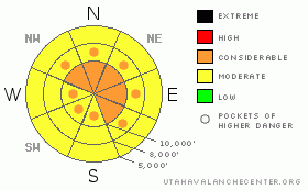
Danger Rose Tutorial
|
Avalanche issues are complex – avalanche training is essential for any travel in avalanche terrain. Reevaluate the snow stability with changing conditions such as wind, heavy snow or heat and sun.
The avalanche danger is Level 3 CONSIDERABLE on slopes approaching 35 degrees and steeper with recent deposits of wind drifted snow. These drifts will be most widespread at the mid and upper elevations, on slopes facing northwest through east. Both human triggered and natural avalanches are possible. During any periods of intense heavy snowfall, the danger of new snow soft slabs and sluffs will also increase to Level 3 CONSIDERABLE.
The chances of triggering a deep slab avalanche have increased to POCKETS of CONSIDERABLE. While isolated, if you were caught in one of these deep slides it might be unsurvivable.
The danger of wet snow avalanche will rise to Level 2 MODERATE with any sun, thin clouds or daytime heating on slopes of all aspects below about 9,000’. |
|
|
CURRENT CONDITIONS |

|
The latest in our March Winter Blast Series arrived in the early morning hours, and as of 6 am the Wasatch mountains have received 5 to 10” of snow, and moderate to heavy snowfall continues. Significant southeasterly winds ahead of the front gusted into 50’s and 60’s in favored locations overnight. Behind the front, winds have shifted to the southwest and west, and decreased into the 15 to 20 mph range. 10,000’ temperatures are in the upper teens, and dropping. |
|
|
RECENT ACTIVITY |

|
Salt Lake and Park city area mountains: Early in the day there were easily triggered soft slabs and loose sluffs, shallow, but up to 200’ wide, generally occurring above about 9,000’, including a natural sluff that hit a person in Coal Pit #4. By about noon, the action shifted to wet loose sluffs, on all aspects, mostly below about 9,000'. There was one short catch and carry on the south face of Reynolds, where a slick, hard sun crust beneath the 5” of snow allowed entrainment. Another deep hard slab natural has occurred in Mineral Fork. Remote sensors indicate the natural avalanche activity occurred early this morning on the steep, south facing slopes above Little Cottonwood Canyon road.
American Fork: Two slides reported, an explosive released hard slab and a skier released soft slab, both about 100 to 200’ wide, large enough to bury a person.
Ogden area mnts: On the backside of Malan peak, a snowboarder was caught, carried and partially buried. He dug himself out, and called for help due to an injured knee, and was hoisted out by Life Flight. Also, the resorts were reporting both shallow hard slabs and deeper soft slabs being released with control work, and sensitive cornices. |
|
|
THREAT #1 |

|
| WHERE |
PROBABILITY |
SIZE |
TREND |

|
|
|
|
| |
|
|
Over the next
8 hours.
|
|
|
The combination of new snow and wind will create sensitive conditions, especially while the snow continues this morning. First, avoid any steep, wind drifted slopes. Winds from the southeast through west have drifted a wide variety of aspects at both mid and upper elevations. Even out of the wind affected terrain, people will be able to trigger sluffs and new snow soft slabs on steep slopes, especially during any period of heavier snowfall or increased winds. |
|
|
THREAT #2 |

|
| WHERE |
PROBABILITY |
SIZE |
TREND |
|
|
|
|
| |
|
|
Over the next
24 hours.
|
|
|
Deep slabs have continued to occur with every loading event for the past month, and the combination of rapid loading from wind and snow with this storm snow will probably be no exception. While a deep slide is most likely to be triggered by the weight of a large cornice drop or a new snow avalanche, I would not rule out the weight of a person triggering a deep slide. With continuing storms, it’s advisable to avoid steep, upper elevation terrain, north through east facing, especially rocky areas and above a cliffs. |
|
|
THREAT #3 |

|
| WHERE |
PROBABILITY |
SIZE |
TREND |

|
|
|
|
| |
|
|
Over the next
10 hours.
|
|
|
The timing of any sun and thin clouds will vary widely today from drainage to drainage. But anywhere the sun peaks through or the clouds thin, the new cold snow will rapidly heat, become very sensitive, and it will be easy to trigger wet sluffs., especially below about 9,000’. These wet sluffs can entrain a fair bit of snow, move long distances, and result in big debris piles. |
|
|
MOUNTAIN WEATHER |

|
Several more hours of moderate to heavy snowfall are possible this morning, with a brief break and sun possible midday. Then a warm front will spread clouds and light precipitation back across the area this afternoon. Temperatures will continue to cool at 10,000’ this morning, bottoming out in the low teens, before they warm once again this afternoon. The westerly winds should continue to decrease, into the 10 to 20 mph range at most locations, though high peaks could average 15 to 25 mph.
The next cold front will arrive tonight, followed by a period of cold, northwest flow on Monday, with storm totals of 10 to 18” possible by Monday night. |
|
|
GENERAL ANNOUNCEMENTS |
If you trigger an avalanche in the backcountry - especially if you are adjacent to a ski area – please call the following teams to alert them to the slide and whether anyone is missing or not. Rescue teams can be exposed to significant hazard when responding to avalanches, and do not want to do so when unneeded. Thanks.
Salt Lake – Alta Central (801-742-2033)
Ogden – Snowbasin Patrol Dispatch (801-620-1017)
Provo – Sundance Patrol Dispatch (801-223-4150)
Discount Lift tickets: Ski Utah, Backcountry.com, Alta, Deer Valley, Park City, The Canyons, Wolf Mountain, Snowbasin, Beaver Mountain, Brighton, Sundance, and Solitude have donated a limited number of tickets for sale.
Wasatch Powderbird Guides flight plan.
Dawn Patrol Forecast Hotline, updated by 05:30: 888-999-4019 option 8.
Daily observations are frequently posted by 10 pm each evening.
Subscribe to the daily avalanche advisory e-mail click HERE.
UDOT canyon closures UDOT at (801) 975-4838
You have the opportunity to participate in the creation of our own community avalanche advisory by submitting avalanche and snow observations. You can also call us at 801-524-5304 or 800-662-4140, or email by clicking HERE
Donate to your favorite non-profit – The Friends of the Utah Avalanche Center. The UAC depends on contributions from users like you to support our work.
The information in this advisory is from the U.S. Forest Service, which is solely responsible for its content. This advisory describes general avalanche conditions and local variations always occur.
We will update this forecast tomorrow morning. Thanks for calling. |
|
|
This information does not apply to developed ski areas or highways where avalanche control is normally done. This advisory is from the U.S.D.A. Forest Service, which is solely responsible for its content. This advisory describes general avalanche conditions and local variations always occur. |
|
This advisory provided by the USDA Forest Service, in partnership with:
The Friends of the Utah Avalanche Center, Utah Division of State Parks and Recreation, Utah Division of Emergency Management, Salt Lake County, Salt Lake Unified Fire Authority and the friends of the La Sal Avalanche Center. See our Sponsors Page for a complete list. |
