SPECIAL ANNOUNCEMENT |
 |
Sundance lift tickets have been reduced to $35! Buy a couple, check out one of Utah's most spectacular mountain resorts, and support the Utah Avalanche Center. Discount Lift tickets |
|
|
BOTTOM LINE
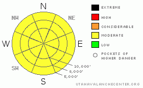
Danger by aspect and elevation on slopes approaching 35° or steeper.
(click HERE for tomorrow's danger rating)
|

Danger Rose Tutorial
|
The avalanche danger today is an overall MODERATE (Level 2). Wet snow avalanches will become possible on many aspects and elevations with day time heating and any direct sun or periods of high thin clouds. There is also a MODERATE (Level 2) danger for triggering a new snow slide or a new wind drift, which are most widespread at the upper elevations with an easterly component. |
|
|
CURRENT CONDITIONS |

|
A wet little storm passed through yesterday and overnight, with many areas below 8,000’ starting with several hours of heavy rain before turning to snow. Water numbers below include the rain.
· Ogden area mountains: up to 8” of snow, 1.9” of water
· Salt Lake area mountains: 6 to 11” of snow, up to 1.4” of water
· Park City area mountains: up to 8” of snow, up to .9” of water
· Provo area mountains: 2 - 4” snow, up to .8” water
Temperatures are refreshing this morning – in the teens at most 8 to 10,000’ elevations, and even a few single digits along the highest ridges. Yesterdays strong southwest to westerly winds are over. Winds are now from the northwest, in the 10 to 15 mph range, gusting to 25. Even the highest peaks are only gusting to 30. I suspect there will be excellent turning and riding conditions at the higher elevations today, where the initial dense snow and graupel has smoothed out the old snow surface, and is topped off with lighter powder. |
|
|
RECENT ACTIVITY |

|
Only one observation came in from the backcountry yesterday – a large, spontaneous wet sluff avalanche observed by Craig on the north facing side of Little Cottonwood. |
|
|
THREAT #1 |

|
| WHERE |
PROBABILITY |
SIZE |
TREND |

|
|
|
|
| |
|
|
Over the next
24 hours.
|
|
|
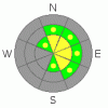
Strong westerly winds occurred during the first ½ of the storm, so sensitive new snow wind drifts along the mid and high elevation ridges and in open bowls will be the number one concern today. These drifts will be most widespread on northeast through southeasterly facing slopes, and could be cross loaded along gully walls and at slope breakovers. The new snow cornices will also be sensitive, and many are sitting on even larger old cornices, and both will tend to break back further than expected. |
|
|
THREAT #2 |

|
| WHERE |
PROBABILITY |
SIZE |
TREND |

|
|
|
|
| |
|
|
Over the next
12 hours.
|
|
|
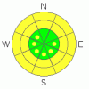
Yesterday’s rain soaked, mid and low elevation wet snow did not have time to cool before being covered by an insulating layer of new snow. Below about 8,000’, wet snow sluffs and human triggered mush-alanches are possible on steep slopes. Even if just the new snow gets moving, it may behave more like wet snow, so be cautious on steep slopes and avoid terrain traps like gullies and creek bottoms.
Secondly, watch out for any breaks in the clouds – the sun is intense now, and it won’t take much to rapidly heat the snow surface on almost all aspects and elevations. With sun, easily triggered loose, wet sluffs and natural avalanches will be possible, especially on steep, southerly and westerly facing slopes. Any periods of high thin clouds will heat the snow on the northerly facing slopes. |
|
|
THREAT #3 |

|
| WHERE |
PROBABILITY |
SIZE |
TREND |

|
|
|
|
| |
|
|
Over the next
12 hours.
|
|
|
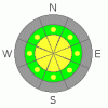
Constantly evaluate the bonding of the new snow to the old snow surface. It could vary rapidly with elevation and aspect – upper elevation, northerly facing slopes had cold, dry old snow, elsewhere there were old crusts. Slope cuts on small test slopes will be a good indicator of the bonding.
And finally, while the deep slab avalanche potential is low, keep a sharp eye out for any evidence that one of the deeper snow pack layers has been overloaded with the weight of the recent storm. |
|
|
MOUNTAIN WEATHER |

|
The slow moving storm system is now stalled to the south of us, and only the Provo area mountains have a chance at a few more inches of snow later today as it moves east and a little north. Further north, we should have overcast to partly cloudy skies today. Temperatures will warm to near 30 at 8,000’ and near 20 at 10,000’. The westerly winds should continue to decrease, into the 5 to 15 mph range, with gusts to 25, and the high peaks gusting to 35. Skies will be partly cloudy tonight, with temperatures dropping into the teens and single digits. A southwest flow will develop again tomorrow, with a few small disturbances bringing periods of light snow over the weekend. |
|
|
This information does not apply to developed ski areas or highways where avalanche control is normally done. This advisory is from the U.S.D.A. Forest Service, which is solely responsible for its content. This advisory describes general avalanche conditions and local variations always occur. |
|
This advisory provided by the USDA Forest Service, in partnership with:
The Friends of the Utah Avalanche Center, Utah Division of State Parks and Recreation, Utah Division of Emergency Management, Salt Lake County, Salt Lake Unified Fire Authority and the friends of the La Sal Avalanche Center. See our Sponsors Page for a complete list. |

