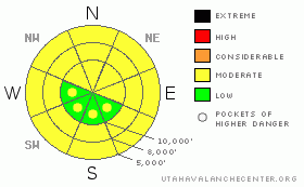
BOTTOM LINE
Danger by aspect and elevation on slopes approaching 35° or steeper.
(click HERE for tomorrow's danger rating)
|
Danger Rose Tutorial
|
The avalanche danger is MODERATE (Level 2) for three issues today:
· Triggering wet loose and wet slab avalanches, on steep low and mid elevation slopes of all aspects, especially on slopes that receive prolonged sun today.
· Triggering a hard wind drift, or wind slab, most widespread in the higher terrain and along ridge lines, and for large, sensitive cornices breaking back further than expected.
· And finally, the isolated possibility of triggering a deep slab avalanche - hard to trigger, but very deep and large if you do. |
|
|
CURRENT CONDITIONS |

|
Light snow is falling in some places this morning, but the grazing storm system isn’t managing to produce much - 1 to 3” near Thaynes on the Park City side, a trace to zero elsewhere. After a warm, windy day and night, winds and temperatures did decrease after midnight. Most stations below freezing this morning, and the westerly winds are less 15 mph, gusting to 20. (Speeds are still higher in the Ogden area mountains, temperatures are just falling below freezing in the Provo area mountains). Between the wind and the sun, dry soft snow is temporarily an endangered species, only to be found on very sheltered, upper elevation northerly facing slopes. |
|
|
RECENT ACTIVITY |

|
Avalanche activity was a variety pack of 6 avalanche types yesterday - large cornices breaking off throughout the Wasatch mountains, some triggering class 2 soft slabs beneath them, skiers could still triggered decent sized sluffs on high, northerly facing slopes, and there were a few shallow wind slabs. There was a wide spread wet loose avalanche cycle on south through west through northerly facing slopes, with the addition of wet slab avalanches in the Ogden area mountains below 8,000’. And finally, an avalauncher round released a 5 foot deep, 350’ wide hard slab in upper Little Cottonwood, probably breaking near the January ice crust. |
|
|
THREAT #1 |

|
| WHERE |
PROBABILITY |
SIZE |
TREND |
|
|
|
|
| |
|
|
Over the next
10 hours.
|
|
|
Warm overnight temperatures and cloud cover will have allowed only a shallow refreeze of the snow pack, especially poor at the low and mid elevations and in the Provo area mountains. Without cooling breezes, wet and soggy snow will be ready to sluff again on steep slopes when the sun comes out and temperatures warm. Wet slab avalanches are also possible at low and mid elevations, so prod around in the snow pack, checking out if there is wet snow beneath frozen crusts. Avoid steep slopes and terrain traps where the snow is wet. |
|
|
THREAT #2 |

|
| WHERE |
PROBABILITY |
SIZE |
TREND |

|
|
|
|
| |
|
|
Over the next
24 hours.
|
|
|
Strong, southwesterly winds yesterday afternoon and overnight created pockets of shallow hard wind drifts, mainly confined to the higher terrain and mid elevation ridge lines. Even shallow hard slabs are tricky – they like to allow you to get out mid slope, and then break above you. Cornices are huge, sensitive to people and breaking off naturally, and breaking back much further than expected. |
|
|
THREAT #3 |

|
| WHERE |
PROBABILITY |
SIZE |
TREND |

|
|
|
|
| |
|
|
Over the next
24 hours.
|
|
|
Yesterday’s control slide in upper Little Cottonwood and the Monday night avalanche cycle in the Provo area mountains show it is still possible to release a slide on a deeply buried faceted weak layer near the January rain crust, but it probably needs a big trigger – cornice drop, slab avalanche, or explosives – and to be in steep, rocky terrain, a shallow rock area, or a slope without compressive strength. |
|
|
MOUNTAIN WEATHER |

|
Skies should clear today for a while, with 8,000’ temperatures warming into the upper 30s, and 10,000’ temperatures to near 30. The westerly winds should remain light, averaging less than 15 mph at most stations, with only the highest peaks gusting into the low 30s. Embedded disturbances in a westerly flow will bring chances for light snow to the mountains through midweek. The first disturbance will bring increasing clouds late this afternoon, with 2 to 5” of snow possible by Saturday afternoon. Light snow is possible again Sunday and Monday. |
|
|
GENERAL ANNOUNCEMENTS |
If you trigger an avalanche in the backcountry - especially if you are adjacent to a ski area – please call the following teams to alert them to the slide and whether anyone is missing or not. Rescue teams can be exposed to significant hazard when responding to avalanches, and do not want to do so when unneeded. Thanks.
Salt Lake – Alta Central (801-742-2033)
Ogden – Snowbasin Patrol Dispatch (801-620-1017)
Provo – Sundance Patrol Dispatch (801-223-4150)
Discount Lift tickets: Ski Utah, Backcountry.com, Alta, Deer Valley, Park City, The Canyons, Wolf Mountain, Snowbasin, Beaver Mountain, Brighton, Sundance, and Solitude have donated a limited number of tickets for sale.
Wasatch Powderbird Guides flight plan.
Dawn Patrol Forecast Hotline, updated by 05:30: 888-999-4019 option 8.
Daily observations are frequently posted by 10 pm each evening.
Subscribe to the daily avalanche advisory e-mail click HERE.
UDOT canyon closures UDOT at (801) 975-4838
You have the opportunity to participate in the creation of our own community avalanche advisory by submitting avalanche and snow observations. You can also call us at 801-524-5304 or 800-662-4140, or email by clicking HERE
Donate to your favorite non-profit – The Friends of the Utah Avalanche Center. The UAC depends on contributions from users like you to support our work.
The information in this advisory is from the U.S. Forest Service, which is solely responsible for its content. This advisory describes general avalanche conditions and local variations always occur.
We will update this forecast tomorrow morning. Thanks for calling. |
|
|
This information does not apply to developed ski areas or highways where avalanche control is normally done. This advisory is from the U.S.D.A. Forest Service, which is solely responsible for its content. This advisory describes general avalanche conditions and local variations always occur. |
|
This advisory provided by the USDA Forest Service, in partnership with:
The Friends of the Utah Avalanche Center, Utah Division of State Parks and Recreation, Utah Division of Emergency Management, Salt Lake County, Salt Lake Unified Fire Authority and the friends of the La Sal Avalanche Center. See our Sponsors Page for a complete list. |
