AVALANCHE WARNING »
Dangerous avalanche conditions are occuring or are imminent.
Backcountry travel in avalanche terrain is not recommended.
|
 |
Notice: An Avalanche Warning has been issued for the Bear River range, Wasatch, central Utah and western Uinta mountains. Strong winds and heavy snowfall have created a HIGH (Level 4) avalanche danger. Dangerous natural and human triggered avalanches are likely, especially on steep wind drifted slopes at the mid and upper elevations. Travel in avalanche terrain – on and below steep slopes – is not recommended. |
|
|
SPECIAL ANNOUNCEMENT |
 |
· The Canyons resort will be doing explosive control work in McDonalds Draw this morning – please avoid the area.
· Big Cottonwood will close for control work at 8 am, hoping to reopen at 9 am. Avoid the Butler Fork trailhead, Circle Awl, Mineral Slabs and Rock House.
· Provo Canyon – intermittent closures for avalanche control work 8 to 11 am, please stay clear of all avalanche paths.
· Little Cottonwood is closed for avalanche control work - please stay clear of all avalanche paths until after roads open. |
|
|
BOTTOM LINE
Danger by aspect and elevation on slopes approaching 35° or steeper.
(click HERE for tomorrow's danger rating)
|
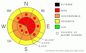
Danger Rose Tutorial
|
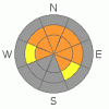
The avalanche danger is HIGH (Level 4) on mid and upper elevation slopes steeper than about 35 degrees with recent deposits of wind drifted snow, where avalanches 1 to 3 feet can be triggered. The avalanche danger is CONSIDERABLE (Level 3) for triggering a deep slab avalanche, on mid and upper elevation slopes facing west through north through southeast. If you are getting out in the backcountry today, seek out lower angle terrain, especially with no steep slopes above or connected to where you are.
If the clouds thin or the sun comes out where you are today, expect a rapid heating of the snow surface, and easily triggered wet loose sluffs. |
|
|
CURRENT CONDITIONS |

|
As of 6 am, storm totals are 2 to 3 feet in the Cottonwoods and Provo area mountains, and 1 to 2 feet on the Park City side and in the Ogden area mountains. Overnight snow is generally denser, 10%, than yesterdays 5% fluff, with numerous reports this morning of a very inverted snowpack. Trail breaking may be a tough proposition today. The southwesterly winds decreased with frontal passage, and are currently in the 10-15 mph range, with gusts in the 30’s. Temperatures are in the low teens at 10,000’ and dropping. |
|
|
RECENT ACTIVITY |

|
Yesterday, once the winds kicked up in the afternoon, the few people in upper elevation terrain reported rapidly changing conditions. There were both natural and easily human triggered new snow slides on wind drifted slopes. West Monitor released naturally about 4-500' wide. Soft slabs were easy to trigger in upper Silver Fork and on the southeast facing Emma’s, where they ran on the sun crust. One test slope was triggered remotely. By late afternoon, many resorts reported very sensitive, widespread new snow soft slabs, many running on crusts. |
|
|
THREAT #1 |

|
| WHERE |
PROBABILITY |
SIZE |
TREND |

|
|
|
|
| |
|
|
Over the next
24 hours.
|
|
|
Though the winds have decreased this morning, the damage is done. The southerly winds ramped up around 2 o’clock yesterday afternoon, blowing 40-50 mph with gusts in the 70 to 90 mph range through midnight, creating dense wind drifts. The wind drifts will start out very sensitive, but will get progressively more stubborn, and may not be reactive to slope cuts, meaning they could then break above you. The winds are expected to increase once again late this morning along the high ridges, creating more blowing and drifting snow. Cornices are large and very sensitive, breaking back much further than expected.
Even out of the wind, the snow is “upside down” – the warmer, dense snow has formed a slab above yesterday’s cold, dry fluff, so avoid travel on steep slopes until this layering starts to settle. |
|
|
THREAT #2 |

|
| WHERE |
PROBABILITY |
SIZE |
TREND |
|
|
|
|
| |
|
|
Over the next
24 hours.
|
|
|
There are several deeper faceted weak layers which vary widely across the range in strength and distribution, and avalanche could break into these deeper weak layers today, triggered by a new snow slide or a person. These slides would be dangerously deep and perhaps unsurvivable. Shallow snowpack areas and wind drifted slopes are the most suspect terrain to trigger one of these deeper slides, particularly along the periphery of the Tri-canyons. With Persistent Weak Layers slides can be triggered remotely from a distance and from below. |
|
|
MOUNTAIN WEATHER |

|
The front is south of I-80 as of 6 am, so south of I-80 heavy to moderate snow will continue through mid morning, before decreasing, with an additional 5 to 9” possible. Snow has tapered off north of I-80, and an additional 1 to 4 inches is possible this morning. The southwesterly winds have decreased for the moment, but are expected to increase once again late morning, with 10 to 20 mph averages and gusts in the 30’s. Winds will be stronger across the highest ridges – 25 to 35 mph averages, with gusts in the 40’s. Temperatures will warm into the mid 20’s at 8,000’. Mostly cloudy skies, light winds and a few snow showers tonight through Sunday. |
|
|
GENERAL ANNOUNCEMENTS |
GENERAL ANNOUNCEMENTS
Lost my snowboard. It fell out of the back of my truck at some point last Sunday off I 80, from Mt Aire, exit 132, to just pass the mouth of Big Cottonwood. Black M3, about 161 length. cochran.erinl@gmail.com
If you trigger an avalanche in the backcountry - especially if you are adjacent to a ski area – please call the following teams to alert them to the slide and whether anyone is missing or not. Rescue teams can be exposed to significant hazard when responding to avalanches, and do not want to do so when unneeded. Thanks.
Salt Lake – Alta Central (801-742-2033)
Ogden – Snowbasin Patrol Dispatch (801-620-1017)
Provo – Sundance Patrol Dispatch (801-223-4150)
Discount Lift tickets: Ski Utah, Backcountry.com, Alta, Deer Valley, Park City, The Canyons, Wolf Mountain, Snowbasin, Beaver Mountain, Brighton, Sundance, and Solitude have donated a limited number of tickets for sale.
Wasatch Powderbird Guides flight plan.
Dawn Patrol Forecast Hotline, updated by 05:30: 888-999-4019 option 8.
Daily observations are frequently posted by 10 pm each evening.
Subscribe to the daily avalanche advisory e-mail click HERE.
UDOT canyon closures UDOT at (801) 975-4838
You have the opportunity to participate in the creation of our own community avalanche advisory by submitting avalanche and snow observations. You can also call us at 801-524-5304 or 800-662-4140, or email by clicking HERE
Donate to your favorite non-profit – The Friends of the Utah Avalanche Center. The UAC depends on contributions from users like you to support our work.
The information in this advisory is from the U.S. Forest Service, which is solely responsible for its content. This advisory describes general avalanche conditions and local variations always occur.
We will update this forecast tomorrow morning. Thanks for calling. |
|
|
This information does not apply to developed ski areas or highways where avalanche control is normally done. This advisory is from the U.S.D.A. Forest Service, which is solely responsible for its content. This advisory describes general avalanche conditions and local variations always occur. |
|
This advisory provided by the USDA Forest Service, in partnership with:
The Friends of the Utah Avalanche Center, Utah Division of State Parks and Recreation, Utah Division of Emergency Management, Salt Lake County, Salt Lake Unified Fire Authority and the friends of the La Sal Avalanche Center. See our Sponsors Page for a complete list. |
